2N304BB 00200 legal, North Plains, OR 97133 - Washington County
0.46 acres in Washington County, Oregon
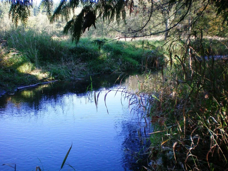
Beautiful setting on East Fork Dairy Creek in North Plains area of Washington County Oregon. Wonderful destination for recreation, reflection, relaxation in natural setting with Creek frontage. Once a part of a small cabin community. John Connell was an early WA County Sheriff who spent time in his original fishing cabin on this parcel. That cabin was destroyed in the Columbus Day Storm in the early sixties. There are remnants of the rock fireplace still on site. This is native Oregon soil and a treasure parcel in lovely place. Value in the land as a natural sanctuary and get away, even if left "as is".
Zoning is AF-5 and per WA County authorities this is a legal lot of record and may be buildable. Currently the lot is located in a flood plain and protected area on Dairy Creek. Buyer must verify all land use and build code with WA. County. Meacham Road and NW Dairy Creek Road create the closest public road intersection in proximity to site. Beaverton and NW Portland are approximately 20 minutes by car.
A newer bridge on Meacham Rd. crosses the Creek and leads to a private deeded access road to level site with trees. No utilities in place. Buyer to do diligence and verify use of property. Worth the effort and priced accordingly.
From elevation to risk assessment
Search for detailed parcel information including; Elevation & Vegetation Maps, Ownership Information, Detailed Parcel Information, Crop History Map, Soil Survey Productivity Data, and more.
Research Parcel InformationEnvironmental Factors
Washington County Properties By Type
- Farms for Sale in Washington County, Oregon
- Undeveloped Land for Sale in Washington County, Oregon
- Residential Property for Sale in Washington County, Oregon
- Commercial Property for Sale in Washington County, Oregon
- Horse Property for Sale in Washington County, Oregon
- Ranches for Sale in Washington County, Oregon
- Lakefront Property for Sale in Washington County, Oregon
- Timberland for Sale in Washington County, Oregon
- Beachfront Property for Sale in Washington County, Oregon
- Hunting Land for Sale in Washington County, Oregon
- Recreational Property for Sale in Washington County, Oregon
- Riverfront Property for Sale in Washington County, Oregon
Properties for Sale Nearby Counties
Washington County Properties By City
- Banks, Oregon Land for Sale
- Beaverton, Oregon Land for Sale
- Buxton, Oregon Land for Sale
- Cornelius, Oregon Land for Sale
- Forest Grove, Oregon Land for Sale
- Gales Creek, Oregon Land for Sale
- Gaston, Oregon Land for Sale
- Hillsboro, Oregon Land for Sale
- Manning, Oregon Land for Sale
- North Plains, Oregon Land for Sale
- Sherwood, Oregon Land for Sale
- Timber, Oregon Land for Sale
- More
- Tualatin, Oregon Land for Sale
- Aloha, Oregon Land for Sale
- Cedar Mill, Oregon Land for Sale
- Durham, Oregon Land for Sale
- Glenwood, Oregon Land for Sale
- Helvetia, Oregon Land for Sale
- King City, Oregon Land for Sale
- Orenco, Oregon Land for Sale
- Progress, Oregon Land for Sale
- Rock Creek, Oregon Land for Sale
- Scholls, Oregon Land for Sale
- Tigard, Oregon Land for Sale
- Verboort, Oregon Land for Sale
- West Slope, Oregon Land for Sale
- West Union, Oregon Land for Sale
- Bacona, Oregon Land for Sale
- Balm Grove, Oregon Land for Sale
- Bethany, Oregon Land for Sale
- Blooming, Oregon Land for Sale
- Bonita, Oregon Land for Sale
- Bonny Slope, Oregon Land for Sale
- Bradley Corner, Oregon Land for Sale
- Buckheaven, Oregon Land for Sale
- Carnation, Oregon Land for Sale
- Cedar Hills, Oregon Land for Sale
- Chehalem, Oregon Land for Sale
- Cherry Grove, Oregon Land for Sale
- Dellwood, Oregon Land for Sale
- Dilley, Oregon Land for Sale
- Elmonica, Oregon Land for Sale
- Farmington, Oregon Land for Sale
- Garden Home, Oregon Land for Sale
- Glencoe, Oregon Land for Sale
- Greenville, Oregon Land for Sale
- Hayward, Oregon Land for Sale
- Hazeldale, Oregon Land for Sale
- Hoodview, Oregon Land for Sale
- Huber, Oregon Land for Sale
- Kansas City, Oregon Land for Sale
- Kinton, Oregon Land for Sale
- Laurel, Oregon Land for Sale
- Laurelwood, Oregon Land for Sale
- Marlene Village, Oregon Land for Sale
- Metzger, Oregon Land for Sale
- Middleton, Oregon Land for Sale
- Midway, Oregon Land for Sale
- Mountaindale, Oregon Land for Sale
- Mulloy, Oregon Land for Sale
- Norwood, Oregon Land for Sale
- Oak Hills, Oregon Land for Sale
- Patton, Oregon Land for Sale
- Raleigh Hills, Oregon Land for Sale
- Reedville, Oregon Land for Sale
- Rockcreek, Oregon Land for Sale
- Six Corners, Oregon Land for Sale
- Somerset West, Oregon Land for Sale
- Stafford, Oregon Land for Sale
- Tanasbourne, Oregon Land for Sale
- Tobias, Oregon Land for Sale
- Watts, Oregon Land for Sale
- West Haven, Oregon Land for Sale
- Whitford, Oregon Land for Sale
- Wilkesboro, Oregon Land for Sale
- Witch Hazel, Oregon Land for Sale