Build the ultimate southwestern getaway, just off the reservation!
OWNER FINANCING AVAILABLE:
$100 down (plus the $250 doc fee)
100/mo for 54 months
---------------------------------
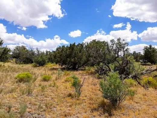
Welcome to Sanders! A small town just off of the old Route 66, its on the cusp of neighboring St. Johns. Located in Apache County, the area has the most land designated as Indian reservation of any county in the United States (68.34% of its area). As part of Apache Park Estates, youll enjoy just over an acre of beautiful southwestern landscape to set up camp and call your own.
You wont be far from Four Corners Monument, which is the only place where four states meet - Arizona, New Mexico, Colorado and Utah. The Hubbell Trading Post National Historic Site is on Highway 191, north of Chambers, with an exhibit center in Ganado, Arizona. It is considered a meeting ground of two cultures between the Navajo and the settlers who came to the area to trade.
Youve got no restrictions on what kind of residence to build and no time limit to build it. Youll need to outfit your remote piece of southwestern paradise with a well, water haul and holding tank and power by solar, wind or generator. The vegetation of the surrounding region includes juniper, pinn pine and a variety of native plants such as prickly pear cactus and sagebrush. You can see pronghorn, deer, cougar, coyote, elk, turkey and quail right outside your back door. Talk about the ultimate way to literally get away from it all, right?
SUBDIVISION: APACHE PARK ESTATES II
STREET ADDRESS: N/A, Sanders AZ 86512
STATE: AZ
COUNTY: Apache County, AZ
ZIP: 86512
SIZE: 1.22 acres
LOT DIMENSIONS: 166 feet x 331 feet
APN: 206-28-109
LEGAL DESCRIPTION: Apache Park Est #2 Lot APN 206-28-109, Apache County, State of Arizona.
LAT/LONG COORDINATES:
NW: 34.976590, -109.320730
NE: 34.976577, -109.320182
SW: 34.975681, -109.320733
SE: 34.975679, -109.320189
ELEVATION: 6,621 ft
ANNUAL TAXES: Approx. $34 per year
ZONING: Agricultural General - No time limit to build. No restrictions on dwelling size. You can build anything for residential purposes such as Single Family, Mobile or Manufactured home.Camping & RV's are okay as well (permits required for long-term stay, more than 30 days).RV's should be at least four hundred (400) square feet, constructed to be towed on its own chassis and designed so as to be installed with or without a permanent foundation for human retail occupancy and/or dwelling residence.Camping in an RVs must be inspected by the Planning and Zoning office to ensure all plumbing and electrical is in working order prior to application approval. It could long term as long as it was approved by the Apache Health Office.Please contact the Apache County Planning & Zoning Dept. through Devin Brown at (928) 337-7547.
HOA/POA: No
IMPROVEMENTS: None
ACCESS: There is a dirt road on the Southern portion of the property.
WATER: Would be a well, water haul and holding tank or other similar option
SEWER: Would be by Septic
UTILITIES: Power by solar, wind or generator, Phone by cellular, satellite TV/Internet/Phone
From elevation to risk assessment
Search for detailed parcel information including; Elevation & Vegetation Maps, Ownership Information, Detailed Parcel Information, Crop History Map, Soil Survey Productivity Data, and more.
Research Parcel InformationDirections
ACCESS: There is a dirt road on the Southern portion of the property.
Environmental Factors
Resources
Apache County Properties By Type
- Undeveloped Land for Sale in Apache County, Arizona
- Beachfront Property for Sale in Apache County, Arizona
- Residential Property for Sale in Apache County, Arizona
- Ranches for Sale in Apache County, Arizona
- Lakefront Property for Sale in Apache County, Arizona
- Farms for Sale in Apache County, Arizona
- Recreational Property for Sale in Apache County, Arizona
- Riverfront Property for Sale in Apache County, Arizona
- Hunting Land for Sale in Apache County, Arizona
- Horse Property for Sale in Apache County, Arizona
- Timberland for Sale in Apache County, Arizona
- Commercial Property for Sale in Apache County, Arizona
Properties for Sale Nearby Counties
- Catron County, Arizona Land for Sale
- Cibola County, Arizona Land for Sale
- Graham County, Arizona Land for Sale
- Greenlee County, Arizona Land for Sale
- McKinley County, Arizona Land for Sale
- Montezuma County, Arizona Land for Sale
- Navajo County, Arizona Land for Sale
- San Juan County, Arizona Land for Sale
- San Juan County, Arizona Land for Sale
Apache County Properties By City
- Alpine, Arizona Land for Sale
- Chambers, Arizona Land for Sale
- Chinle, Arizona Land for Sale
- Concho, Arizona Land for Sale
- Dennehotso, Arizona Land for Sale
- Eagar, Arizona Land for Sale
- Fort Defiance, Arizona Land for Sale
- Ganado, Arizona Land for Sale
- Greer, Arizona Land for Sale
- Houck, Arizona Land for Sale
- Lukachukai, Arizona Land for Sale
- Lupton, Arizona Land for Sale
- More
- Many Farms, Arizona Land for Sale
- Mcnary, Arizona Land for Sale
- Nazlini, Arizona Land for Sale
- Nutrioso, Arizona Land for Sale
- Rock Point, Arizona Land for Sale
- Round Rock, Arizona Land for Sale
- Saint Johns, Arizona Land for Sale
- Saint Michaels, Arizona Land for Sale
- Sanders, Arizona Land for Sale
- Springerville, Arizona Land for Sale
- Teec Nos Pos, Arizona Land for Sale
- Vernon, Arizona Land for Sale
- Window Rock, Arizona Land for Sale
- Concho Valley, Arizona Land for Sale
- Cornfields, Arizona Land for Sale
- Greasewood, Arizona Land for Sale
- Klagetoh, Arizona Land for Sale
- Mexican Water, Arizona Land for Sale
- Red Mesa, Arizona Land for Sale
- Richville, Arizona Land for Sale
- Rough Rock, Arizona Land for Sale
- Salado, Arizona Land for Sale
- Salina, Arizona Land for Sale
- Steamboat Canyon, Arizona Land for Sale
- Sunrise Springs, Arizona Land for Sale
- Tahchee, Arizona Land for Sale
- Toyei, Arizona Land for Sale
- Adamana, Arizona Land for Sale
- Allentown, Arizona Land for Sale
- Boneyard, Arizona Land for Sale
- Bonita Trading Post, Arizona Land for Sale
- Burnside, Arizona Land for Sale
- Chetco, Arizona Land for Sale
- Correjo Crossing, Arizona Land for Sale
- Cove, Arizona Land for Sale
- Coyote Springs, Arizona Land for Sale
- Crosby Crossing, Arizona Land for Sale
- Del Muerto, Arizona Land for Sale
- Diamond Fields, Arizona Land for Sale
- El Tule, Arizona Land for Sale
- Emmanuel Mission, Arizona Land for Sale
- Feaster, Arizona Land for Sale
- Flat Rock, Arizona Land for Sale
- Green Spot, Arizona Land for Sale
- Greer Place, Arizona Land for Sale
- Hawley Lake, Arizona Land for Sale
- Heap Place, Arizona Land for Sale
- Hunt, Arizona Land for Sale
- Hunters Point, Arizona Land for Sale
- Junction Overlook, Arizona Land for Sale
- Kinlichee, Arizona Land for Sale
- Kinney Junction, Arizona Land for Sale
- Los Burros, Arizona Land for Sale
- Lower Wheatfields, Arizona Land for Sale
- Maverick, Arizona Land for Sale
- Mexican Water Trading Post, Arizona Land for Sale
- Milkwater, Arizona Land for Sale
- Navajo, Arizona Land for Sale
- Northwoods, Arizona Land for Sale
- Oak Springs, Arizona Land for Sale
- Paulcell Place, Arizona Land for Sale
- Pine Springs, Arizona Land for Sale
- Pinta, Arizona Land for Sale
- Potter Place, Arizona Land for Sale
- Rosebud, Arizona Land for Sale
- Sand Springs, Arizona Land for Sale
- Sehili, Arizona Land for Sale
- Steamboat, Arizona Land for Sale
- Tanner Springs, Arizona Land for Sale
- Tes Nez Iah, Arizona Land for Sale
- Three Forks, Arizona Land for Sale
- Totacon, Arizona Land for Sale
- Troweek, Arizona Land for Sale
- Tsintaa Yiti Ii, Arizona Land for Sale
- Twin Falls, Arizona Land for Sale
- Upper Wheatfields, Arizona Land for Sale
- Wheatfields, Arizona Land for Sale
- White Clay, Arizona Land for Sale
- Wide Ruins, Arizona Land for Sale
- Wood Springs, Arizona Land for Sale
- Woodspring Trading Post, Arizona Land for Sale
- Yazzi, Arizona Land for Sale