10 AC Sierra Blanca, TX 79851 Hudspeth County
Texas Hudspeth County 10.17 Acres Raw, Off-Grid Desert Freedom!
Big Sky Views Eagle Peak Mountain Scenery Dirt Road Access Only $169/Month
Escape to the wide-open West Texas desert with this 10.17-acre off-grid property in Hudspeth County part of the legendary Trans-Pecos Region, known for its rugged beauty, dark star-filled skies, and unbeatable privacy.
Located near the Rio Grande investment corridor with sweeping views of Eagle Peak, this land offers true freedom. No HOA, no restrictions, no neighbors just pure open desert, dirt-road access, and endless potential for recreation, camping, ATV riding, homesteading, or long-term investment.
Property Details
Gov. File #: L-30159
APN: 1105912 / 1 X506-000-0006-0130
Legal Description: Lot 13, Block 6, Section 6, T&P RR PID 106286 Culberson CAD
County/State: Hudspeth County, Texas
Size: 10.17 acres
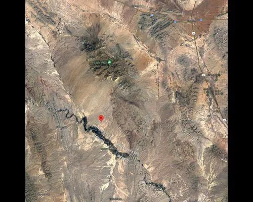
GPS (center): 30.772130, -105.111061
Just plug the coordinates into Google Maps for directions and aerial views.
Pricing
Cash Price: $12,478
Closing Cost / Deed Recording: $199
Easy Owner Financing
No banks. No credit checks. No hassles.
Down Payment: $299
Monthly Payment: $169/month
Interest: 8.0% APR
No prepayment penalty pay off anytime and save.
Property Taxes: ~$30/year ($2.50/month, added to payment)
Property Highlights
10.17 acres of raw, undeveloped land perfect for off-grid living
Direct dirt-road access
Huge mountain views, including Eagle Peak
Dark desert skies ideal for stargazing
Excellent area for camping, hunting, ATV riding, RVing, or a remote getaway
No HOA No restrictions unlimited freedom
Strong long-term investment region near the Rio Grande corridor
Part of the Trans-Pecos West Texas landscape remote, peaceful, and beautiful
If youre looking for isolation, open land, and a property you can truly make your own, this is it.
From elevation to risk assessment
Search for detailed parcel information including; Elevation & Vegetation Maps, Ownership Information, Detailed Parcel Information, Crop History Map, Soil Survey Productivity Data, and more.
Research Parcel InformationDirections
Centroid GPS Coordinates: 30.772130, -105.1110610
Just plug those into Google maps for directions and aerial views.
Land for Sale by Tom Richerson
Hudspeth County Properties By Type
- Ranches for Sale in Hudspeth County, Texas
- Undeveloped Land for Sale in Hudspeth County, Texas
- Hunting Land for Sale in Hudspeth County, Texas
- Residential Property for Sale in Hudspeth County, Texas
- Farms for Sale in Hudspeth County, Texas
- Recreational Property for Sale in Hudspeth County, Texas
- Riverfront Property for Sale in Hudspeth County, Texas
- Commercial Property for Sale in Hudspeth County, Texas
- Horse Property for Sale in Hudspeth County, Texas
- Lakefront Property for Sale in Hudspeth County, Texas
- Beachfront Property for Sale in Hudspeth County, Texas
- Timberland for Sale in Hudspeth County, Texas
Properties for Sale Nearby Counties
Hudspeth County Properties By City
- Dell City, Texas Land for Sale
- Fort Hancock, Texas Land for Sale
- Salt Flat, Texas Land for Sale
- Sierra Blanca, Texas Land for Sale
- Acala, Texas Land for Sale
- Allamoore, Texas Land for Sale
- Arispe, Texas Land for Sale
- Brownfeld Corner, Texas Land for Sale
- Cornudas, Texas Land for Sale
- Coyote Place, Texas Land for Sale
- Crusher, Texas Land for Sale
- Eagle Flat, Texas Land for Sale
- More
