BUILDABLE NEVADA LAND NEXT TO BLM FOR SALE LYON COUNTY NV
***PRICE REDUCTION!***
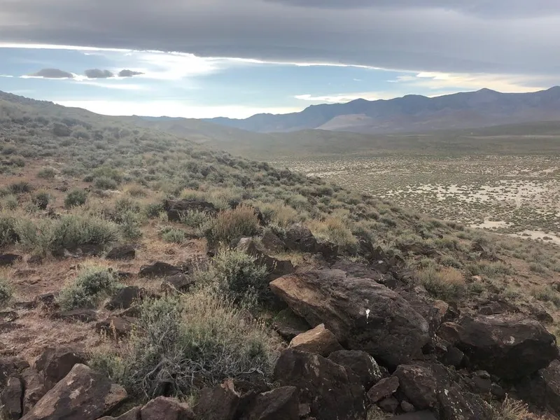
COME LIVE YOUR DREAM ON THIS 10 ACRES OF RECREATIONAL LAND AND FREEDOM ON LEEGARD AVE. NEAR STAGECOACH, NEVADA.
There is such a high demand for these nice buildable parcels adjacent to BLM Land, close enough to town, but yet, far enough away from the hustle and bustle, this one shouldn't last long. You will only be 1 Mi S. of Hwy 50, 2+ miles to the Carson River through BLM land and about .32 Mi to power and the nearest neighbors. Saddle up the Bay or fire up the UTV and head for the hills and river out your back gate! No improvements or utilities on this parcel.
GPS Coordinates
NW: 39.3204, -119.4456
NE: 39.3204, -119.4444
SW: 39.3168, -119.4455
SE: 39.3168, -119.4443
Center: 39.3186, -119.4449
LOCATION, LOCATION, LOCATION!
-Direct/Adjacent Access to Thousands of acres of BLM Land
-1 Mi to Hwy 50
-2+ Mi to the Carson River
-9+ Mi to Shopping and Dayton, NV
-22 Mi to Carson City, NV
-35 Mi to Reno-Tahoe International Airport and Reno/Sparks
-48 Mi to S. Lake Tahoe, CA/Stateline, NV
Property Information:
County: Lyon County, Nevada
Acres: 10
APN:01546102
Yearly Taxes: $53.41
Elevation: 4,280- 4,400 Ft.
Zoning: RR5
Land Use Code: 120: Vacant - Single Family Residence
Electricity: Approximately .32 Mi away
Water: A well will be needed.
Water Rights - Well Needed - 1,800 Gallons Per Day from a Domestic Well
Sewer: A septic system will be needed.
Road Frontage: Dirt
Time Limit to Build: None
Type of Terrain: Level, Gentle slope, Steep,Varied
FISHING
Information on Carson River Fishing - Courtesy of NDOW.org
History - The main Carson River begins near the town of Genoa where the east and west forks merge and it ends at the Carson Sink beyond Fallon. Pioneers (mid- to late 1800s) originally fished for native trout, however, Comstock mining activities, channelization, water diversions, introduction of other fishes, and overharvesting caused the demise of cutthroat trout and limited the range of mountain whitefish.
Pertinent Information - The Carson River fishery primarily begins at Mexican Dam (adjacent to Carson City) and ends in Dayton. Some fishing does occur in the river upstream of Ft. Churchill, but it depends on the flow and water conditions. The river is considered navigable, making it accessible to the public below the average high water line. However, land upstream of Mexican Dam is mostly private and it is difficult to find public access to the river. Entrance to the river, however, occurs frequently from Carson City to Dayton with Dayton State Park being about the lower end of easily accessible public land. A put and take trout fishery occurs in these areas along with large- and smallmouth bass. Channel catfish and bullheads are caught more in the lower reaches near Ft. Churchill. A canoe/raft launch site along with a handicap access-fishing platform can be found at Camp Carson Park near Lloyds Bridge (Carson City). There is an additional boat launch/takeout at Morgan Mill Park near the BLM office.
From elevation to risk assessment
Search for detailed parcel information including; Elevation & Vegetation Maps, Ownership Information, Detailed Parcel Information, Crop History Map, Soil Survey Productivity Data, and more.
Research Parcel InformationMore Land for Sale in Lyon County
Lyon County Properties By Type
- Undeveloped Land for Sale in Lyon County, Nevada
- Residential Property for Sale in Lyon County, Nevada
- Ranches for Sale in Lyon County, Nevada
- Commercial Property for Sale in Lyon County, Nevada
- Farms for Sale in Lyon County, Nevada
- Lakefront Property for Sale in Lyon County, Nevada
- Recreational Property for Sale in Lyon County, Nevada
- Riverfront Property for Sale in Lyon County, Nevada
- Horse Property for Sale in Lyon County, Nevada
- Hunting Land for Sale in Lyon County, Nevada
- Timberland for Sale in Lyon County, Nevada
- Beachfront Property for Sale in Lyon County, Nevada
Properties for Sale Nearby Counties
Lyon County Properties By City
- Dayton, Nevada Land for Sale
- Fernley, Nevada Land for Sale
- Silver City, Nevada Land for Sale
- Silver Springs, Nevada Land for Sale
- Smith, Nevada Land for Sale
- Wellington, Nevada Land for Sale
- Yerington, Nevada Land for Sale
- Mason, Nevada Land for Sale
- Simpson, Nevada Land for Sale
- Stagecoach, Nevada Land for Sale
- Wabuska, Nevada Land for Sale
- Weed Heights, Nevada Land for Sale
- More
- Argo, Nevada Land for Sale
- Carson Rapids City, Nevada Land for Sale
- Churchill, Nevada Land for Sale
- Como, Nevada Land for Sale
- Darwin, Nevada Land for Sale
- Davis Station, Nevada Land for Sale
- Greenville, Nevada Land for Sale
- Lux, Nevada Land for Sale
- Nordyke, Nevada Land for Sale
- Pine Grove, Nevada Land for Sale
- Ramsey Station, Nevada Land for Sale
- Sulfur, Nevada Land for Sale
- Sutro, Nevada Land for Sale
- Talapoosa, Nevada Land for Sale
- Twin Flat, Nevada Land for Sale
- Wellington Springs, Nevada Land for Sale
- Wichman, Nevada Land for Sale