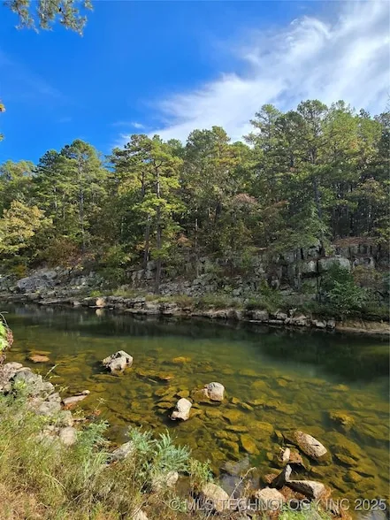
10 acres in Pushmataha County, OK
1
From elevation to risk assessment
Search for detailed parcel information including; Elevation & Vegetation Maps, Ownership Information, Detailed Parcel Information, Crop History Map, Soil Survey Productivity Data, and more.
Research Parcel InformationDirections
From Antlers take highway 2 going north for 8.4 miles slightly ft onto murrel loop.2 miles turn left onto john valleys road 3.6 mile, turn left Sherman road follow sherman road 2 miles turn left at Buck Creek road. the .3 miles turn turn right onto Pearson road. The low water big at Buck Creek is on the property. 34.36143, -95.66976. gps directions
Environmental Factors
Contact Seller
Listing provided by
Debra Portman
American Dream Realty(580) 407-4246
Source: Homes, MLS# 2548047
Listing last updated: February 5, 2026 at 6:25 AM
Listing last checked: February 4, 2026 at 6:01 AM
Report this listing
Land for Sale by Debra Portman
Pushmataha County Properties By Type
- Undeveloped Land for Sale in Pushmataha County, Oklahoma
- Hunting Land for Sale in Pushmataha County, Oklahoma
- Farms for Sale in Pushmataha County, Oklahoma
- Ranches for Sale in Pushmataha County, Oklahoma
- Riverfront Property for Sale in Pushmataha County, Oklahoma
- Recreational Property for Sale in Pushmataha County, Oklahoma
- Lakefront Property for Sale in Pushmataha County, Oklahoma
- Timberland for Sale in Pushmataha County, Oklahoma
- Residential Property for Sale in Pushmataha County, Oklahoma
- Commercial Property for Sale in Pushmataha County, Oklahoma
- Horse Property for Sale in Pushmataha County, Oklahoma
- Beachfront Property for Sale in Pushmataha County, Oklahoma
Properties for Sale Nearby Counties
Pushmataha County Properties By City
- Albion, Oklahoma Land for Sale
- Antlers, Oklahoma Land for Sale
- Clayton, Oklahoma Land for Sale
- Finley, Oklahoma Land for Sale
- Moyers, Oklahoma Land for Sale
- Nashoba, Oklahoma Land for Sale
- Rattan, Oklahoma Land for Sale
- Snow, Oklahoma Land for Sale
- Tuskahoma, Oklahoma Land for Sale
- Adel, Oklahoma Land for Sale
- Belzoni, Oklahoma Land for Sale
- Big Rocks, Oklahoma Land for Sale
- More
- Cloudy, Oklahoma Land for Sale
- Corinne, Oklahoma Land for Sale
- Dela, Oklahoma Land for Sale
- Divide, Oklahoma Land for Sale
- Dunbar, Oklahoma Land for Sale
- Ethel, Oklahoma Land for Sale
- Eubanks, Oklahoma Land for Sale
- Fewell, Oklahoma Land for Sale
- Greenwood, Oklahoma Land for Sale
- Jumbo, Oklahoma Land for Sale
- Kellond, Oklahoma Land for Sale
- Kosoma, Oklahoma Land for Sale
- Miller, Oklahoma Land for Sale
- Nashoba Y, Oklahoma Land for Sale
- Nolia, Oklahoma Land for Sale
- North Sobol, Oklahoma Land for Sale
- Oleta, Oklahoma Land for Sale
- Pine Knot Crossing, Oklahoma Land for Sale
- Sardis, Oklahoma Land for Sale
- Sobol, Oklahoma Land for Sale
- Stanley, Oklahoma Land for Sale
- Wadena, Oklahoma Land for Sale
