Parcel # 50106027 / Wyandotte Rd, Williams, AZ 86046 - Coconino County
Is this your property? Sell it faster with premium placement and targeted ads.
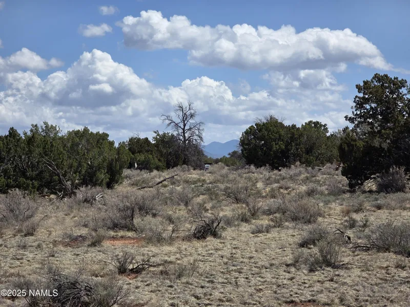
LAND - Williams, AZ
Description
Serene 10-Acre Parcel with Easement Access - Lightly Treed Land Near Grand Canyon Discover wide-open space, natural beauty, and endless sky with this 10-acre parcel just west of 564 Wyandotte in the Grand Canyon Subdivision. Situated at approximately 6,000 feet elevation, this lot offers cooler summer temperatures, lightly treed terrain, and a front-row seat to Arizona's raw and rugged landscape. Located just 35 minutes from the Grand Canyon South Rim, this property puts you within striking distance of one of the world's most awe-inspiring landmarks-while still enjoying the peace and privacy of rural living. You'll find basic amenities in nearby Valle, Williams, and Flagstaff, making it a practical choice for off-grid recreation or future development. Enjoy stargazing under pristine night skies, with the Milky Way visible above and wildlife roaming freely around youdeer, elk, antelope, and more call this area home. The land features Painted Desert soil, light tree coverage for added charm, and an existing easement for access. 10 acres of lightly treed, high desert land Easement access No HOA or POA Zoned General (10-acre minimum) - Confirm with Coconino County for intended use Perfect for off-grid living, recreation, or investment 4WD recommended due to unmaintained roads Adjoining 10-acre parcel also available This land offers a place to unplug, unwind, and reconnectwith nature, with quiet, and with yourself. Whether you're planning your future homestead or just looking for a place to breathe, this property invites you to envision something different.
Copyright © 2026 Northern Arizona Multiple Listing Service. All rights reserved. All information provided by the listing agent/broker is deemed reliable but is not guaranteed and should be independently verified.
From elevation to risk assessment
Search for detailed parcel information including; Elevation & Vegetation Maps, Ownership Information, Detailed Parcel Information, Crop History Map, Soil Survey Productivity Data, and more.
Research Parcel InformationEnvironmental Factors
Is this your property? Sell it faster with premium placement and targeted ads.
Coconino County Properties By Type
- Undeveloped Land for Sale in Coconino County, Arizona
- Ranches for Sale in Coconino County, Arizona
- Residential Property for Sale in Coconino County, Arizona
- Recreational Property for Sale in Coconino County, Arizona
- Farms for Sale in Coconino County, Arizona
- Lakefront Property for Sale in Coconino County, Arizona
- Riverfront Property for Sale in Coconino County, Arizona
- Hunting Land for Sale in Coconino County, Arizona
- Timberland for Sale in Coconino County, Arizona
- Horse Property for Sale in Coconino County, Arizona
- Commercial Property for Sale in Coconino County, Arizona
- Beachfront Property for Sale in Coconino County, Arizona
Properties for Sale Nearby Counties
Coconino County Properties By City
- Bellemont, Arizona Land for Sale
- Cameron, Arizona Land for Sale
- Flagstaff, Arizona Land for Sale
- Fredonia, Arizona Land for Sale
- Grand Canyon, Arizona Land for Sale
- Gray Mountain, Arizona Land for Sale
- Happy Jack, Arizona Land for Sale
- Leupp, Arizona Land for Sale
- Marble Canyon, Arizona Land for Sale
- Mormon Lake, Arizona Land for Sale
- Munds Park, Arizona Land for Sale
- North Rim, Arizona Land for Sale
- More
- Page, Arizona Land for Sale
- Parks, Arizona Land for Sale
- Supai, Arizona Land for Sale
- Tonalea, Arizona Land for Sale
- Tuba City, Arizona Land for Sale
- Williams, Arizona Land for Sale
- Grand Canyon Caverns, Arizona Land for Sale
- Jacob Lake, Arizona Land for Sale
- Kaibab, Arizona Land for Sale
- Leupp Corner, Arizona Land for Sale
- Red Lake, Arizona Land for Sale
- Allan Lake Landing, Arizona Land for Sale
- Angell, Arizona Land for Sale
- Apex, Arizona Land for Sale
- Babbit Winter, Arizona Land for Sale
- Big Springs, Arizona Land for Sale
- Bishop Place, Arizona Land for Sale
- Bitter Springs, Arizona Land for Sale
- Black Falls Crossing, Arizona Land for Sale
- Bootlegger Crossing, Arizona Land for Sale
- Cane, Arizona Land for Sale
- Canyon Diablo, Arizona Land for Sale
- Chair Crossing, Arizona Land for Sale
- Chalender, Arizona Land for Sale
- Clints Well, Arizona Land for Sale
- Coal Mine Mesa, Arizona Land for Sale
- Coconino, Arizona Land for Sale
- Cogdill Center, Arizona Land for Sale
- Corva, Arizona Land for Sale
- Cosnino, Arizona Land for Sale
- Cow Springs, Arizona Land for Sale
- Coyote Basin Ranch, Arizona Land for Sale
- Cucamonga Junction, Arizona Land for Sale
- Darling, Arizona Land for Sale
- Daze, Arizona Land for Sale
- Dennison, Arizona Land for Sale
- Durfee Crossing, Arizona Land for Sale
- East Flagstaff, Arizona Land for Sale
- Echinique Place, Arizona Land for Sale
- Elden Pueblo, Arizona Land for Sale
- Fort Tuthill, Arizona Land for Sale
- Frazier Wells, Arizona Land for Sale
- Hidden Springs Mission, Arizona Land for Sale
- Horse Crossing, Arizona Land for Sale
- Indian Gardens, Arizona Land for Sale
- Jones Crossing, Arizona Land for Sale
- Kachina Village, Arizona Land for Sale
- Kaibito, Arizona Land for Sale
- Kinder Crossing, Arizona Land for Sale
- Lakeview, Arizona Land for Sale
- LeChee, Arizona Land for Sale
- Little Spring, Arizona Land for Sale
- Long Valley, Arizona Land for Sale
- Lost Eden, Arizona Land for Sale
- Lower Tillman, Arizona Land for Sale
- Macks Crossing, Arizona Land for Sale
- Maine, Arizona Land for Sale
- Mangum Springs, Arizona Land for Sale
- Meteor City, Arizona Land for Sale
- Moenave, Arizona Land for Sale
- Moenkopi, Arizona Land for Sale
- Moqui, Arizona Land for Sale
- Mormon Crossing, Arizona Land for Sale
- Mountainaire, Arizona Land for Sale
- Mule Crossing, Arizona Land for Sale
- Nagles Crossing, Arizona Land for Sale
- Navajo Mountain Mission, Arizona Land for Sale
- Old Leupp, Arizona Land for Sale
- One Mile, Arizona Land for Sale
- Pilgrim Playground, Arizona Land for Sale
- Pine Tank, Arizona Land for Sale
- Pumpkin Center, Arizona Land for Sale
- Quivero, Arizona Land for Sale
- Rare Metals, Arizona Land for Sale
- Rimmy Jims, Arizona Land for Sale
- Riordan, Arizona Land for Sale
- Robbers Roost, Arizona Land for Sale
- Rockledge, Arizona Land for Sale
- Rose Well Camp, Arizona Land for Sale
- Ryan, Arizona Land for Sale
- Saint Joseph Youth Camp, Arizona Land for Sale
- Sereno, Arizona Land for Sale
- Sereno Spring, Arizona Land for Sale
- Stoneman Lake, Arizona Land for Sale
- Sunrise, Arizona Land for Sale
- Sunshine, Arizona Land for Sale
- Tempe Camp, Arizona Land for Sale
- Tiis Holoni, Arizona Land for Sale
- Tin House, Arizona Land for Sale
- Tolani Lake, Arizona Land for Sale
- Tolchico, Arizona Land for Sale
- Turkey Crossing, Arizona Land for Sale
- Tusayan, Arizona Land for Sale
- Two Guns, Arizona Land for Sale
- Valle, Arizona Land for Sale
- Victorine Crossing, Arizona Land for Sale
- Vista Encantada, Arizona Land for Sale
- Wahweap, Arizona Land for Sale
- Whitted Place, Arizona Land for Sale
- Wiggins Crossing, Arizona Land for Sale
- Willaha, Arizona Land for Sale
- Williams Junction, Arizona Land for Sale
- Willow Springs, Arizona Land for Sale
- Winona, Arizona Land for Sale
- Winslow West, Arizona Land for Sale
- Wolf Crossing, Arizona Land for Sale
- Woodin, Arizona Land for Sale