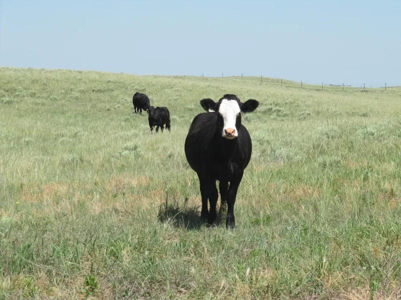
CRP/Farmland/Pasture Combo
+/- 1000 acres, 206.6 of which is enrolled in CRP.
Township 5 North, Range 57 West of the 6th P.M.: The South of the South in Section 3, The North of the Northwest , the Southeast of the Northwest and the Northeast of the Southwest and The Southeast of Section 4, The Southeast of Section 10, The Northeast of the Northeast of Section 15, The North of Section 14.
2014 Taxes = $747.36.
151.2 Acres enrolled in the CRP program until September 30, 2018 with an annual payment of $4,981.00. 55.4 Acres is enrolled in the CRP program until September 30, 2015 with an annual payment of $1,466.00.
GRAZING ACRES = 702
DRY LAND ACRES = 287
OTHER = 11
From elevation to risk assessment
Search for detailed parcel information including; Elevation & Vegetation Maps, Ownership Information, Detailed Parcel Information, Crop History Map, Soil Survey Productivity Data, and more.
Research Parcel InformationDirections
From I-76 in Ft. Morgan take Hwy 52 north to CR EE, go east to CR 21 and south to CR DD. Signs will be posted. Signs will be posted.
Resources
Land for Sale by Ryan Hostetler
Weld County Properties By Type
- Undeveloped Land for Sale in Weld County, Colorado
- Farms for Sale in Weld County, Colorado
- Ranches for Sale in Weld County, Colorado
- Commercial Property for Sale in Weld County, Colorado
- Residential Property for Sale in Weld County, Colorado
- Horse Property for Sale in Weld County, Colorado
- Lakefront Property for Sale in Weld County, Colorado
- Hunting Land for Sale in Weld County, Colorado
- Riverfront Property for Sale in Weld County, Colorado
- Recreational Property for Sale in Weld County, Colorado
- Timberland for Sale in Weld County, Colorado
- Beachfront Property for Sale in Weld County, Colorado
Properties for Sale Nearby Counties
- Adams County, Colorado Land for Sale
- Boulder County, Colorado Land for Sale
- Broomfield County, Colorado Land for Sale
- Kimball County, Colorado Land for Sale
- Laramie County, Colorado Land for Sale
- Larimer County, Colorado Land for Sale
- Logan County, Colorado Land for Sale
- Morgan County, Colorado Land for Sale
Weld County Properties By City
- Ault, Colorado Land for Sale
- Briggsdale, Colorado Land for Sale
- Carr, Colorado Land for Sale
- Dacono, Colorado Land for Sale
- Eaton, Colorado Land for Sale
- Erie, Colorado Land for Sale
- Evans, Colorado Land for Sale
- Firestone, Colorado Land for Sale
- Fort Lupton, Colorado Land for Sale
- Frederick, Colorado Land for Sale
- Galeton, Colorado Land for Sale
- Gilcrest, Colorado Land for Sale
- More
- Gill, Colorado Land for Sale
- Greeley, Colorado Land for Sale
- Grover, Colorado Land for Sale
- Hereford, Colorado Land for Sale
- Hudson, Colorado Land for Sale
- Johnstown, Colorado Land for Sale
- Keenesburg, Colorado Land for Sale
- Kersey, Colorado Land for Sale
- La Salle, Colorado Land for Sale
- Lucerne, Colorado Land for Sale
- Mead, Colorado Land for Sale
- Milliken, Colorado Land for Sale
- New Raymer, Colorado Land for Sale
- Nunn, Colorado Land for Sale
- Pierce, Colorado Land for Sale
- Platteville, Colorado Land for Sale
- Roggen, Colorado Land for Sale
- Severance, Colorado Land for Sale
- Stoneham, Colorado Land for Sale
- Windsor, Colorado Land for Sale
- Garden City, Colorado Land for Sale
- Raymer, Colorado Land for Sale
- Adna, Colorado Land for Sale
- Alden, Colorado Land for Sale
- Auburn, Colorado Land for Sale
- Avalo, Colorado Land for Sale
- Barnesville, Colorado Land for Sale
- Bracewell, Colorado Land for Sale
- Bruce, Colorado Land for Sale
- Buckingham, Colorado Land for Sale
- Buda, Colorado Land for Sale
- Bunyan, Colorado Land for Sale
- Canton, Colorado Land for Sale
- Cloverly, Colorado Land for Sale
- Comer, Colorado Land for Sale
- Cornish, Colorado Land for Sale
- Dearfield, Colorado Land for Sale
- Dent, Colorado Land for Sale
- Dick, Colorado Land for Sale
- Dover, Colorado Land for Sale
- East La Salle, Colorado Land for Sale
- Elm, Colorado Land for Sale
- Elwell, Colorado Land for Sale
- Evanston, Colorado Land for Sale
- Farmers, Colorado Land for Sale
- Fosston, Colorado Land for Sale
- Gates, Colorado Land for Sale
- Gowanda, Colorado Land for Sale
- Greeley Junction, Colorado Land for Sale
- Hambert, Colorado Land for Sale
- Hardin, Colorado Land for Sale
- Hardman, Colorado Land for Sale
- Harney, Colorado Land for Sale
- Highland Lake, Colorado Land for Sale
- Hillsboro, Colorado Land for Sale
- Houston, Colorado Land for Sale
- Hurrich, Colorado Land for Sale
- Idaho Creek, Colorado Land for Sale
- Jackson Field, Colorado Land for Sale
- Jessum, Colorado Land for Sale
- Johnson, Colorado Land for Sale
- Kahler, Colorado Land for Sale
- Keota, Colorado Land for Sale
- Kirkland, Colorado Land for Sale
- Krauss, Colorado Land for Sale
- Kuner, Colorado Land for Sale
- Lowe, Colorado Land for Sale
- Maloy, Colorado Land for Sale
- Mason Corner, Colorado Land for Sale
- Masters, Colorado Land for Sale
- Matthews, Colorado Land for Sale
- Mumper Corner, Colorado Land for Sale
- Peckham, Colorado Land for Sale
- Plumbs, Colorado Land for Sale
- Powars, Colorado Land for Sale
- Prospect Valley, Colorado Land for Sale
- Pulliam, Colorado Land for Sale
- Purcell, Colorado Land for Sale
- Puritan, Colorado Land for Sale
- Rinn, Colorado Land for Sale
- Rockport, Colorado Land for Sale
- Rosedale, Colorado Land for Sale
- Roy, Colorado Land for Sale
- Saint Vrains, Colorado Land for Sale
- Sloan, Colorado Land for Sale
- South Roggen, Colorado Land for Sale
- Spanish Village, Colorado Land for Sale
- Stage, Colorado Land for Sale
- Tampa, Colorado Land for Sale
- Tonville, Colorado Land for Sale
- Vollmar, Colorado Land for Sale
- Walker, Colorado Land for Sale
- Warren, Colorado Land for Sale
- Wattenberg, Colorado Land for Sale
- Welty, Colorado Land for Sale
- Wildcat, Colorado Land for Sale