10401 South Cedar Ridge Trail, Grain Valley, MO 64029 - Jackson County
Incredible Jackson County Build Site with New Barn and Pond
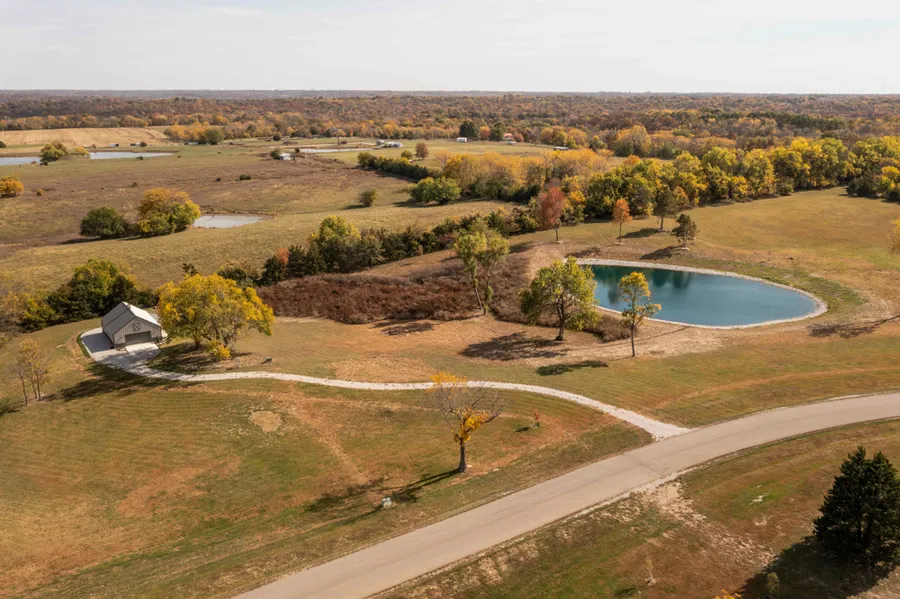
You can stop looking any further as you will be hard-pressed to find a better build site with acreage in Jackson County! This 10.34 +/- acre tract is located just east of Lake Lotawana within the upscale Cedar Ridge Trail subdivision. This amazing subdivision consists of nine beautiful 10.34 +/- acre build lots and is located across from Blue and Gray Park which features over 1,700 +/- acres of horse riding and hiking trails. The land is accessed on a winding dead-end blacktop subdivision road. Rural water and electricity meters are already in place on the property!
The first thing you will notice is the incredible curb appeal and welcoming feeling that this property has. It has been very well maintained and manicured. Check out the renovated pond with a park-like setting. There are mature trees and amazing views in several locations, making it tough to decide which spot to build your dream home! Escape from the neighborhood life and have room to roam. Enjoy amazing sunrises and sunsets. The possibilities are endless!
A picturesque 30’x40’ steel frame barn is already in place with concrete, water, and electricity. It also features an amazing covered front porch. Between the barn, pond, water, electric, and additional land renovations, the owners have invested over $150,000 in property improvements. Talk about a turn-key setup!
This one stands out! Build sites this beautiful and close to the city are hard to come by! Contact Skyler Wirsig at (816) 500-0168 for more information or to schedule a showing.
Property Features
-10.34 +/- acres
-Blacktop road access
-Water and electric meters
-Picturesque build site
-Amazing views
-Mature trees
-Renovated pond
-30’x40’ steel frame barn with water and electricity
-6’x40’ covered front porch
-Great recreational opportunities
-Across from Blue and Gray Park
-Lee’s Summit School District
-10 miles to Blue Springs
-12 miles to Lee’s Summit
-25 miles to Kansas City
-Under 1 hour to Kansas City International Airport
From elevation to risk assessment
Search for detailed parcel information including; Elevation & Vegetation Maps, Ownership Information, Detailed Parcel Information, Crop History Map, Soil Survey Productivity Data, and more.
Research Parcel InformationDirections
50 Highway east to Buckner Tarsney Road, then north to Hammond Road, go east to subdivision on the left, Cedar Ridge Trail.
Resources
Land for Sale by Skyler Wirsig
Jackson County Properties By Type
- Farms for Sale in Jackson County, Missouri
- Undeveloped Land for Sale in Jackson County, Missouri
- Hunting Land for Sale in Jackson County, Missouri
- Residential Property for Sale in Jackson County, Missouri
- Ranches for Sale in Jackson County, Missouri
- Recreational Property for Sale in Jackson County, Missouri
- Lakefront Property for Sale in Jackson County, Missouri
- Commercial Property for Sale in Jackson County, Missouri
- Riverfront Property for Sale in Jackson County, Missouri
- Timberland for Sale in Jackson County, Missouri
- Horse Property for Sale in Jackson County, Missouri
- Beachfront Property for Sale in Jackson County, Missouri
Properties for Sale Nearby Counties
Jackson County Properties By City
- Blue Springs, Missouri Land for Sale
- Buckner, Missouri Land for Sale
- Grain Valley, Missouri Land for Sale
- Grandview, Missouri Land for Sale
- Greenwood, Missouri Land for Sale
- Independence, Missouri Land for Sale
- Kansas City, Missouri Land for Sale
- Lees Summit, Missouri Land for Sale
- Levasy, Missouri Land for Sale
- Lone Jack, Missouri Land for Sale
- Oak Grove, Missouri Land for Sale
- Sibley, Missouri Land for Sale
- More
- Lake Lotawana, Missouri Land for Sale
- Lake Tapawingo, Missouri Land for Sale
- Lake Winnebago, Missouri Land for Sale
- Martin City, Missouri Land for Sale
- Raytown, Missouri Land for Sale
- Sugar Creek, Missouri Land for Sale
- Unity Village, Missouri Land for Sale
- Adams, Missouri Land for Sale
- Air Line Junction, Missouri Land for Sale
- Atherton, Missouri Land for Sale
- Belvidere, Missouri Land for Sale
- Blue Mills, Missouri Land for Sale
- Bristol, Missouri Land for Sale
- Bryant, Missouri Land for Sale
- Cement City, Missouri Land for Sale
- Centropolis, Missouri Land for Sale
- Cobbler, Missouri Land for Sale
- Cockrell, Missouri Land for Sale
- Courtney, Missouri Land for Sale
- Dallas, Missouri Land for Sale
- Dodson, Missouri Land for Sale
- East Independence, Missouri Land for Sale
- Eton, Missouri Land for Sale
- Fairmount, Missouri Land for Sale
- Flinn, Missouri Land for Sale
- Hickman Mills, Missouri Land for Sale
- Hicks City, Missouri Land for Sale
- Hiler, Missouri Land for Sale
- Holmes Park, Missouri Land for Sale
- Indian Village, Missouri Land for Sale
- Jeffreys, Missouri Land for Sale
- Knobtown, Missouri Land for Sale
- Lake City, Missouri Land for Sale
- Leeds, Missouri Land for Sale
- Little Blue, Missouri Land for Sale
- Longview, Missouri Land for Sale
- Melville, Missouri Land for Sale
- Mount Washington, Missouri Land for Sale
- New Santa Fe, Missouri Land for Sale
- Pink Hill, Missouri Land for Sale
- Red Bridge, Missouri Land for Sale
- Ripley, Missouri Land for Sale
- River Bend, Missouri Land for Sale
- Rock Creek Junction, Missouri Land for Sale
- Ruskin, Missouri Land for Sale
- Ruskin Heights, Missouri Land for Sale
- Selsa, Missouri Land for Sale
- Sni Mills, Missouri Land for Sale
- South Lee, Missouri Land for Sale
- Tarsney, Missouri Land for Sale
- Tarsney Lakes, Missouri Land for Sale
- Truman Corners, Missouri Land for Sale
- Union Point, Missouri Land for Sale
- Vale, Missouri Land for Sale
- Westport, Missouri Land for Sale
- Lee's Summit, Missouri Land for Sale