71365 ROAD 367, Trenton, NE 69044 - Hitchcock County
105 acres in Hitchcock County, Nebraska
LEGAL DESCRIPTION: E/2NE/4 & SW/4NE/4 OF 6-2-32
LOCATION: From Trenton, NE on Hwy 25, go mile South to Road 713, 2 miles East to Road 367, then mile North to the driveway on West side.
Located 6 miles from Swanson Reservoir & just South of the Republican River!!
MINERAL RIGHTS: Seller is transferring surface rights only.
CROPS: Crops are subject to a cash lease agreement with the 2011 payment to be prorated to the date of closing.
POSSESSION:
Tract 1: Date of closing, subject to tenants rights
Tract 2: Date of closing.
FSA INFORMATION:
Tract 1: Cropland acres - 85.1
Base Acres DCP Yield
Corn 46.0 119
Tract 2: Grassland & Improvements acres - 19.8
REAL ESTATE TAXES: Seller will pay taxes for all of 2010 and prior years. Taxes for 2011 will be prorated to the date of closing.
(2010 taxes are combined in the amount of $2901.92)
PRICE REDUCED:
Tract 1: $120,000 (Cropland acres)
Tract 2: $279,000 (Grass & Improvements)
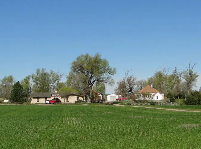
TRACT 2 - IMPROVEMENTS
BEAUTIFUL, MODERN
1,608 SQ. FT. HOME
3 Bedrooms
2 baths
Fireplace
Underground sprinklers
2-car attached garage
Detached garage w/ small OH doors
Good barn built in 1915, well preserved
Large machinery building w/OH doors and other supporting outbuildings
There is a grass lane connecting the farmstead to the pasture.
There is a second home with 3 bedrooms that can be used as a guest cottage or hunting lodge!
IRRIGATION INFORMATION:
4 sideroll sprinklers are included in the sale. Well was overhauled in 2004, equipped with 6 pump (4 CFM).
8 of ditch water is available on the SW 31.6 acres at $33 acre cost per year which has already been paid for 2010 by Seller.
EQIP: 50.2 acres enrolled from 2009-2012 (2nd signup). Land was originally enrolled in EQIP in 2005.
Annual payment $5623 in 2010 & 2011 (no payment in 2012)
Buyer receives 100% of EQIP payments 2011
From elevation to risk assessment
Search for detailed parcel information including; Elevation & Vegetation Maps, Ownership Information, Detailed Parcel Information, Crop History Map, Soil Survey Productivity Data, and more.
Research Parcel InformationResources
Land for Sale by Donald L. Hazlett
Hitchcock County Properties By Type
- Farms for Sale in Hitchcock County, Nebraska
- Ranches for Sale in Hitchcock County, Nebraska
- Hunting Land for Sale in Hitchcock County, Nebraska
- Lakefront Property for Sale in Hitchcock County, Nebraska
- Recreational Property for Sale in Hitchcock County, Nebraska
- Riverfront Property for Sale in Hitchcock County, Nebraska
- Residential Property for Sale in Hitchcock County, Nebraska
- Timberland for Sale in Hitchcock County, Nebraska
- Commercial Property for Sale in Hitchcock County, Nebraska
- Undeveloped Land for Sale in Hitchcock County, Nebraska
- Horse Property for Sale in Hitchcock County, Nebraska
- Beachfront Property for Sale in Hitchcock County, Nebraska