Socagee Creek
Description
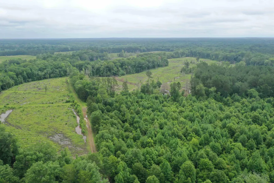
Socagee Creek is a historic industry timberland tract being offered for the first time to the general public as a multi-use recreational and timber tract. The property offers planted pine plantations in the upland areas and dropping down to the banks of historic Socagee Creek. Located along the banks of Socagee Creek, this tract is centrally located between Carthage, TX, and Logansport, LA. The Sabine River courses a couple of miles south as Socagee Creek flows into the larger river. Highway 31, the nearest paved highway, connects Logansport, LA. Logansport, The Sand Bass Capital of the World, is known for its rich history and recreational opportunities. The property is accessed through a deeded easement from CR449, off Farm to Market Rd 31. The easement is approximately 2.3 miles and is recorded with the county as an Exhibit B on the Deed or Records. Flooded timber along Socagee Bayou provides the potential for Arkansas-style duck hunting in East Texas. Socagee Creek is a rare find with creek frontage, hardwood bottoms, planted loblolly pine, and close proximity to the Sabine River and Sabine River Authority Wildlife Management Area. This historic timberland tract offers 70 acres of fully stocked pine plantation established in 2024. The plantation pine was intensively site-prepped, planted with second-generation containerized seedlings from the IFCO nursery in DeRidder, LA, and sprayed for herbaceous weed control to minimize competition to the seedlings. Approximately 15 acres of mature pine remain, giving the potential for some immediate return on the investment. The creek banks have been protected in Stream Side Management Zones (SMZ), providing wildlife travel corridors and a mosaic canvas of mature natural forests that break up the young plantation pine.
From elevation to risk assessment
Search for detailed parcel information including; Elevation & Vegetation Maps, Ownership Information, Detailed Parcel Information, Crop History Map, Soil Survey Productivity Data, and more.
Research Parcel InformationDirections
From FM 31, turn south on CR449. Travel CR449 as it turns into a private road (the easement) approximately 3.5 miles to enter the property.
Environmental Factors
Resources
Panola County Properties By Type
- Undeveloped Land for Sale in Panola County, Texas
- Ranches for Sale in Panola County, Texas
- Farms for Sale in Panola County, Texas
- Lakefront Property for Sale in Panola County, Texas
- Residential Property for Sale in Panola County, Texas
- Recreational Property for Sale in Panola County, Texas
- Timberland for Sale in Panola County, Texas
- Hunting Land for Sale in Panola County, Texas
- Riverfront Property for Sale in Panola County, Texas
- Commercial Property for Sale in Panola County, Texas
- Horse Property for Sale in Panola County, Texas
- Beachfront Property for Sale in Panola County, Texas
Properties for Sale Nearby Counties
Panola County Properties By City
- Beckville, Texas Land for Sale
- Carthage, Texas Land for Sale
- Clayton, Texas Land for Sale
- De Berry, Texas Land for Sale
- Gary, Texas Land for Sale
- Long Branch, Texas Land for Sale
- Panola, Texas Land for Sale
- Fair Play, Texas Land for Sale
- Galloway, Texas Land for Sale
- Grand Bluff, Texas Land for Sale
- Horton, Texas Land for Sale
- Bethany, Texas Land for Sale
- More
- Buncome, Texas Land for Sale
- Centennial, Texas Land for Sale
- Daniels, Texas Land for Sale
- Deadwood, Texas Land for Sale
- DeBerry, Texas Land for Sale
- Delray, Texas Land for Sale
- Harris Chapel, Texas Land for Sale
- Holland Quarters, Texas Land for Sale
- Hudson Mast, Texas Land for Sale
- Logan, Texas Land for Sale
- Midyett, Texas Land for Sale
- Old Center, Texas Land for Sale
- Pleasant Ridge, Texas Land for Sale
- Riderville, Texas Land for Sale
- River Hill, Texas Land for Sale
- Sterrett Hill, Texas Land for Sale