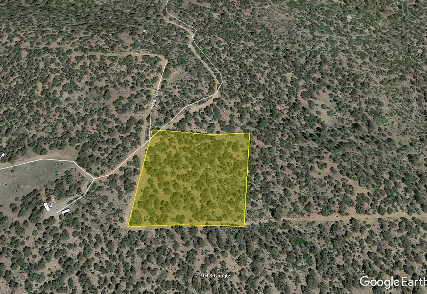
Trees! 2.40 Acres in Colorado
Own a piece of Colorado land with gorgeous mountain views, plenty of trees, and easy access, on a better than your average, dirt road. This 2.4 acre property is roughly 15 miles north of Westcliffe, Colorado and sits between Canon City and Cotopaxi, with an elevation slightly above 7,000ft. You can copy and paste the GPS coordinates below to pull it up on a map to view. I like this property for the clear access road, tree coverage, and most of all location. If you're in the area, or have the time to view I think you'll find this part of Fremont County wonderful.
This is an undeveloped area of Colorado still, where you'll see off-grid living, vacation and full time cabins, camping, and of course, tons of recreation! What's around you? A lot. You'll find the Arkansas River Floats, Sangre de Cristo Mountains local fishing, Rainbow Trail, ATV and Jeep courses and tours, and there is a lot of BLM land for hunting. The diverse geologic and geographic features of Fremont County offer beautiful landscapes, rugged mountains, majestic forests, and endless blue skies. Summer time will surely be a perfect time to enjoy your outdoor activities with family.
Slow down, and enjoy Colorado livin' on your own 2.40 acres of land.
Parcel ID: 76000750
Approx GPS Coordinates: 38.309529, -105.450629
From elevation to risk assessment
Search for detailed parcel information including; Elevation & Vegetation Maps, Ownership Information, Detailed Parcel Information, Crop History Map, Soil Survey Productivity Data, and more.
Research Parcel InformationResources
Land for Sale by Miles McLaughlin
Fremont County Properties By Type
- Undeveloped Land for Sale in Fremont County, Colorado
- Riverfront Property for Sale in Fremont County, Colorado
- Ranches for Sale in Fremont County, Colorado
- Lakefront Property for Sale in Fremont County, Colorado
- Residential Property for Sale in Fremont County, Colorado
- Hunting Land for Sale in Fremont County, Colorado
- Farms for Sale in Fremont County, Colorado
- Commercial Property for Sale in Fremont County, Colorado
- Horse Property for Sale in Fremont County, Colorado
- Recreational Property for Sale in Fremont County, Colorado
- Timberland for Sale in Fremont County, Colorado
- Beachfront Property for Sale in Fremont County, Colorado
Properties for Sale Nearby Counties
Fremont County Properties By City
- Canon City, Colorado Land for Sale
- Coal Creek, Colorado Land for Sale
- Coaldale, Colorado Land for Sale
- Cotopaxi, Colorado Land for Sale
- Florence, Colorado Land for Sale
- Hillside, Colorado Land for Sale
- Howard, Colorado Land for Sale
- Penrose, Colorado Land for Sale
- Rockvale, Colorado Land for Sale
- Buckskin Joe, Colorado Land for Sale
- Portland, Colorado Land for Sale
- Prospect Heights, Colorado Land for Sale
- More
- Texas Creek, Colorado Land for Sale
- Williamsburg, Colorado Land for Sale
- Adelaide, Colorado Land for Sale
- Brookside, Colorado Land for Sale
- Concrete, Colorado Land for Sale
- East Canon, Colorado Land for Sale
- Echo, Colorado Land for Sale
- Fink, Colorado Land for Sale
- Galena, Colorado Land for Sale
- Lincoln Park, Colorado Land for Sale
- Orchard Park, Colorado Land for Sale
- Park Center, Colorado Land for Sale
- Pleasanton, Colorado Land for Sale
- Sample, Colorado Land for Sale
- Sikes, Colorado Land for Sale
- Sunset City, Colorado Land for Sale
- Vallie, Colorado Land for Sale
- Whitehorn, Colorado Land for Sale
- Yorkville, Colorado Land for Sale