Multi Use Tract Near Bull Shoals Lake
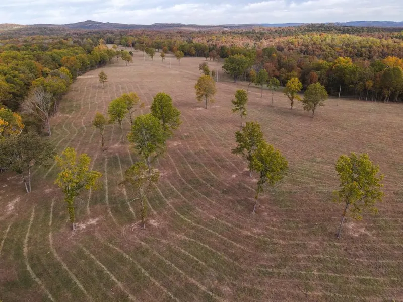
Situated just minutes north of Bull Shoals Lake and the Arkansas border lies this 124 +/- acre tract in Taney County, Missouri. This tract offers nearly 45 +/- acres of pasture ground that are easily accessible. State Highway OO borders this property for just under a mile along its entire western edge, offering multiple established access points. The remaining acreage in this tract consists of recently thinned timber and several small clearings. While this timber has been thinned recently, a solid stand of mature hardwoods and even a few pines remain in place. The recent timber harvest has created a substantial amount of wildlife food and cover, making this property a wildlife magnet which is very evident upon touring the property.
There is one pond located in the center of the property and a wet weather creek lies in the northern portion of the property. Access to electricity is no issue as power runs through a portion of the pasture. Access to Bull Shoals Lake is located at the end of State Highway OO, just 5 minutes from the property. This cove is in a quiet and secluded part of the lake, so you won't have to worry about heavy traffic during prime lake season. If you are looking for a multi-use tract with no restrictions, look no further. More adjoining acreage is available for purchase. For more information or to set up your private showing, contact Land Agent, Clay O'Dell at (417) 612-8215.
Property Features
-124 +/- acres
-45 +/- acres of pasture
-0.7 miles of State Highway OO frontage
-1 pond
-Wet weather creek
-Great hunting potential
-Access to electricity
-35 minutes to Branson, MO
-1 hour and 15 minutes to Springfield, MO
-1 hour and 15 minutes to Harrison, AR
From elevation to risk assessment
Search for detailed parcel information including; Elevation & Vegetation Maps, Ownership Information, Detailed Parcel Information, Crop History Map, Soil Survey Productivity Data, and more.
Research Parcel InformationDirections
From Branson, MO, take State Highway 76 East and continue for 12 miles. Take a slight right onto US-160 and continue for 2.9 miles, then turn right onto US-160 East and continue for 6 miles. Take a right onto State Highway M and continue for 7.7 miles and continue onto State Highway OO for 2 miles, property is on the left.
Resources
Land for Sale by Clay O'Dell
Taney County Properties By Type
- Farms for Sale in Taney County, Missouri
- Undeveloped Land for Sale in Taney County, Missouri
- Hunting Land for Sale in Taney County, Missouri
- Residential Property for Sale in Taney County, Missouri
- Ranches for Sale in Taney County, Missouri
- Riverfront Property for Sale in Taney County, Missouri
- Lakefront Property for Sale in Taney County, Missouri
- Commercial Property for Sale in Taney County, Missouri
- Recreational Property for Sale in Taney County, Missouri
- Timberland for Sale in Taney County, Missouri
- Horse Property for Sale in Taney County, Missouri
- Beachfront Property for Sale in Taney County, Missouri
Properties for Sale Nearby Counties
Taney County Properties By City
- Bradleyville, Missouri Land for Sale
- Branson, Missouri Land for Sale
- Cedarcreek, Missouri Land for Sale
- Forsyth, Missouri Land for Sale
- Hollister, Missouri Land for Sale
- Kirbyville, Missouri Land for Sale
- Kissee Mills, Missouri Land for Sale
- Powersite, Missouri Land for Sale
- Protem, Missouri Land for Sale
- Ridgedale, Missouri Land for Sale
- Rockaway Beach, Missouri Land for Sale
- Rueter, Missouri Land for Sale
- More
- Taneyville, Missouri Land for Sale
- Walnut Shade, Missouri Land for Sale
- Gretna, Missouri Land for Sale
- Mildred, Missouri Land for Sale
- Mincy, Missouri Land for Sale
- Silver Dollar City, Missouri Land for Sale
- Brownbranch, Missouri Land for Sale
- Bull Creek, Missouri Land for Sale
- Day, Missouri Land for Sale
- Dickens, Missouri Land for Sale
- Edgewater Beach, Missouri Land for Sale
- Garber, Missouri Land for Sale
- Hercules, Missouri Land for Sale
- Hilda, Missouri Land for Sale
- Irma, Missouri Land for Sale
- Long Beach, Missouri Land for Sale
- McClurg, Missouri Land for Sale
- Melva, Missouri Land for Sale
- Merriam Woods, Missouri Land for Sale
- Nance, Missouri Land for Sale
- Oakmont, Missouri Land for Sale
- Ozark Beach, Missouri Land for Sale
- Swan, Missouri Land for Sale
- Table Rock, Missouri Land for Sale
- Cedar Creek, Missouri Land for Sale