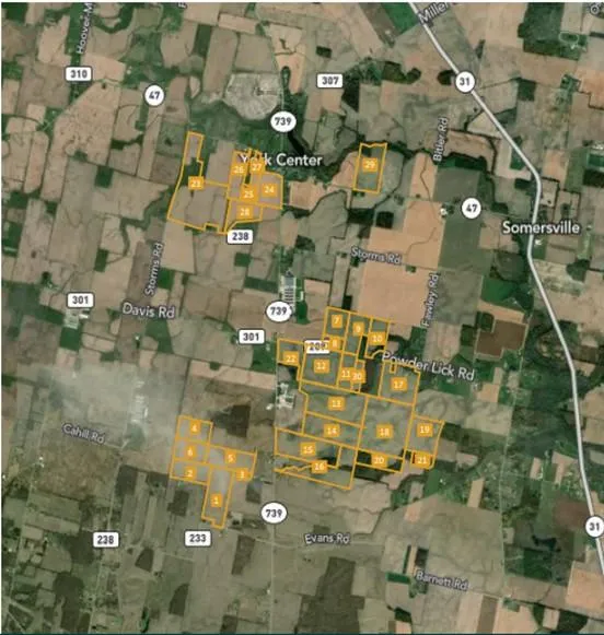
1243.67 AC UNION COUNTY, OH
APX. 1243.67 AC, VMS 3234/3237/3238/3239/3470/5387/6680 YORK TWP.& VMS 14912/16133, LIBERTY TWP., UNION CO. PROPERTY CONSISTS OF 30 PARCELS WITH AMPLE ROAD FRONTAGE OFF POWDER LICK RD., SR 739, STORMS RD. & EVANS RD. NEAR RAYMOND, YORK CENTER & WEST MANSFIELD. APX. 1125.84 TILLABLE ACRES. SOILS CONSIST PRIMARILY OF BLOUNT, WETZEL, & GLYNWOOD. MARYSVILLE & NORTH UNION LSD. TAXES ARE CAUV. $25,000 PER ACRE.
From elevation to risk assessment
Search for detailed parcel information including; Elevation & Vegetation Maps, Ownership Information, Detailed Parcel Information, Crop History Map, Soil Survey Productivity Data, and more.
Research Parcel InformationDirections
USE GPS
Environmental Factors
Resources
Attachments
Contact Seller
Listing provided by
Ron Spencer
Ron Spencer Real Estate, Inc.(567) 371-6930
Source: MLS# 1016484
Listing last updated: January 2, 2026 at 12:24 PM
Report this listing
Land for Sale by Ron Spencer
Union County Properties By Type
- Farms for Sale in Union County, Ohio
- Undeveloped Land for Sale in Union County, Ohio
- Residential Property for Sale in Union County, Ohio
- Ranches for Sale in Union County, Ohio
- Hunting Land for Sale in Union County, Ohio
- Recreational Property for Sale in Union County, Ohio
- Timberland for Sale in Union County, Ohio
- Commercial Property for Sale in Union County, Ohio
- Lakefront Property for Sale in Union County, Ohio
- Horse Property for Sale in Union County, Ohio
- Beachfront Property for Sale in Union County, Ohio
- Riverfront Property for Sale in Union County, Ohio
Properties for Sale Nearby Counties
Union County Properties By City
- Broadway, Ohio Land for Sale
- Magnetic Springs, Ohio Land for Sale
- Marysville, Ohio Land for Sale
- Milford Center, Ohio Land for Sale
- Raymond, Ohio Land for Sale
- Richwood, Ohio Land for Sale
- Unionville Center, Ohio Land for Sale
- Allen Center, Ohio Land for Sale
- Arbela, Ohio Land for Sale
- Arnold, Ohio Land for Sale
- Byhalia, Ohio Land for Sale
- Chuckery, Ohio Land for Sale
- More
- Claiborne, Ohio Land for Sale
- Dipple, Ohio Land for Sale
- Essex, Ohio Land for Sale
- Fleetwood Park, Ohio Land for Sale
- Jerome, Ohio Land for Sale
- Lunda, Ohio Land for Sale
- Millcreek Meadows, Ohio Land for Sale
- New California, Ohio Land for Sale
- New Dover, Ohio Land for Sale
- Otter, Ohio Land for Sale
- Peoria, Ohio Land for Sale
- Pharisburg, Ohio Land for Sale
- Pottersburg, Ohio Land for Sale
- Summersville, Ohio Land for Sale
- Watkins, Ohio Land for Sale
- West Jackson, Ohio Land for Sale
- Woodland, Ohio Land for Sale
- Woodview Park, Ohio Land for Sale
- York Center, Ohio Land for Sale