Highway Frontage
125 acres for $512,500
Owner May Divide in Half.
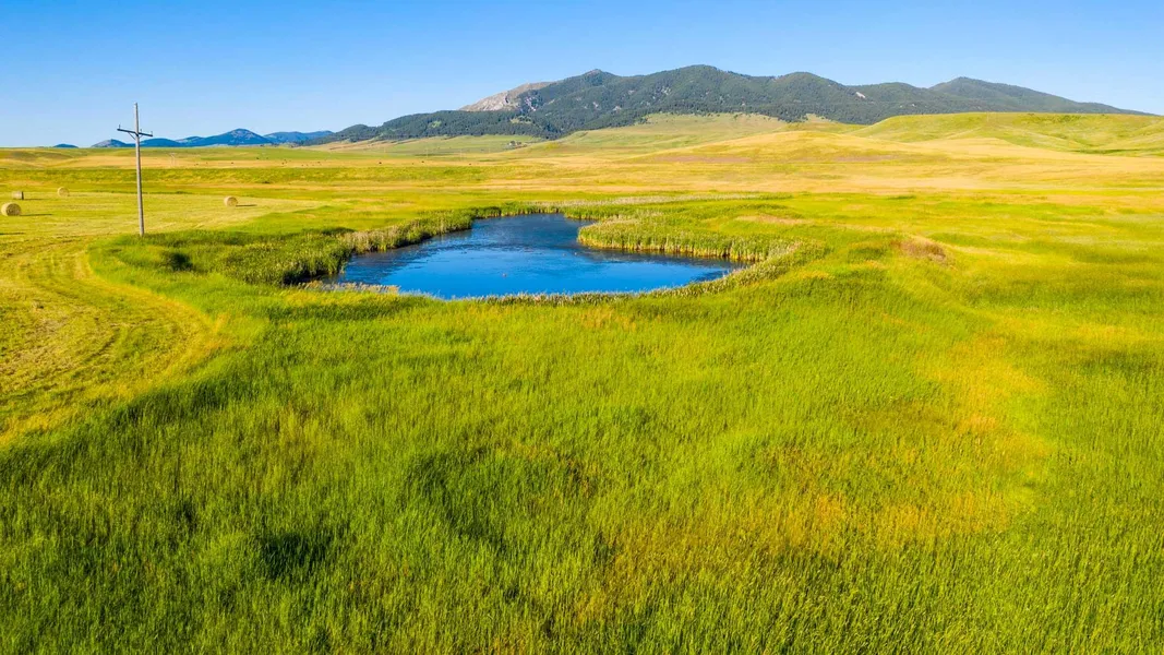
This property includes 125 acres a short 5 miles North of Lewistown, Montana bordering HWY 191. It is nestled in the valley between the Judith and Moccasin Mountains. The current use is for hay production with 98 acres allocated as Tillable Land. Burnette Creek, a small seasonal stream, meanders through the property's east boundary for almost a half mile. Then feeds the water into a 1 acre pond. The abundant water allows for waterfowl and upland birds to flourish in this highly desirable area. Adjacent to the property is both the Upper and Lower Carters Ponds. Upper Carters Pond is a public fishing area for Trout, Perch and Bluegill. The location of this 125 acres is very close to Central Montanas finest community and embodies the rich scenic land, we all enjoy.
From elevation to risk assessment
Search for detailed parcel information including; Elevation & Vegetation Maps, Ownership Information, Detailed Parcel Information, Crop History Map, Soil Survey Productivity Data, and more.
Research Parcel InformationEnvironmental Factors
Land for Sale by Phillips Realty
Fergus County Properties By Type
- Ranches for Sale in Fergus County, Montana
- Farms for Sale in Fergus County, Montana
- Undeveloped Land for Sale in Fergus County, Montana
- Commercial Property for Sale in Fergus County, Montana
- Hunting Land for Sale in Fergus County, Montana
- Residential Property for Sale in Fergus County, Montana
- Riverfront Property for Sale in Fergus County, Montana
- Lakefront Property for Sale in Fergus County, Montana
- Timberland for Sale in Fergus County, Montana
- Horse Property for Sale in Fergus County, Montana
- Recreational Property for Sale in Fergus County, Montana
- Beachfront Property for Sale in Fergus County, Montana
Properties for Sale Nearby Counties
- Blaine County, Montana Land for Sale
- Chouteau County, Montana Land for Sale
- Golden Valley County, Montana Land for Sale
- Judith Basin County, Montana Land for Sale
- Musselshell County, Montana Land for Sale
- Petroleum County, Montana Land for Sale
- Phillips County, Montana Land for Sale
- Wheatland County, Montana Land for Sale
Fergus County Properties By City
- Coffee Creek, Montana Land for Sale
- Denton, Montana Land for Sale
- Forest Grove, Montana Land for Sale
- Grass Range, Montana Land for Sale
- Hilger, Montana Land for Sale
- Lewistown, Montana Land for Sale
- Moore, Montana Land for Sale
- Roy, Montana Land for Sale
- Winifred, Montana Land for Sale
- Heath, Montana Land for Sale
- Straw, Montana Land for Sale
- Amherst, Montana Land for Sale
- More
- Ayers Ranch Colony, Montana Land for Sale
- Baxter, Montana Land for Sale
- Becket, Montana Land for Sale
- Bell Ranch Colony, Montana Land for Sale
- Brooks, Montana Land for Sale
- Christina, Montana Land for Sale
- Cottonwood, Montana Land for Sale
- Danvers, Montana Land for Sale
- Deerfield Colony, Montana Land for Sale
- Eddies Corner, Montana Land for Sale
- Fergus, Montana Land for Sale
- Forestgrove, Montana Land for Sale
- Giltedge, Montana Land for Sale
- Glengarry, Montana Land for Sale
- Hanover, Montana Land for Sale
- Hoosac, Montana Land for Sale
- King Colony Ranch, Montana Land for Sale
- Kingston, Montana Land for Sale
- Lewistown Heights, Montana Land for Sale
- Lewistown Junction, Montana Land for Sale
- Maiden, Montana Land for Sale
- McClave, Montana Land for Sale
- Moulton, Montana Land for Sale
- New Year, Montana Land for Sale
- Piper, Montana Land for Sale
- Pownal, Montana Land for Sale
- Ross Fork, Montana Land for Sale
- Roy-Winifred Junction, Montana Land for Sale
- Samples Crossing, Montana Land for Sale
- Spring Creek Junction, Montana Land for Sale
- Suffolk, Montana Land for Sale
- Valentine, Montana Land for Sale
- Ware, Montana Land for Sale
- West Lewistown, Montana Land for Sale