111 400 Lane, Hay Springs, NE 69347 - Sheridan County
Box Butte Creek Ranch * Sheridan County * Nebraska Land for Sale
Description
SOLD but we have others available
Home for Sale * Real Estate for Sale * Chadron, Nebraska
Please call our office at (308) 432-6828
Western View Real Estate
For more information about Farm and Ranch Land for Sale in Nebraska or South Dakota
Contact Philip J Rosfeld, Broker/Owner, Licensed in Nebraska and South Dakota
(308) 432-6828 Day or Night (308) 430-5151
Farm and Ranch * Recreational * Land for Sale
Western View Real Estate
Financial verification required for all showings. Contact listing broker for additional information.
Shown by Appointment Only
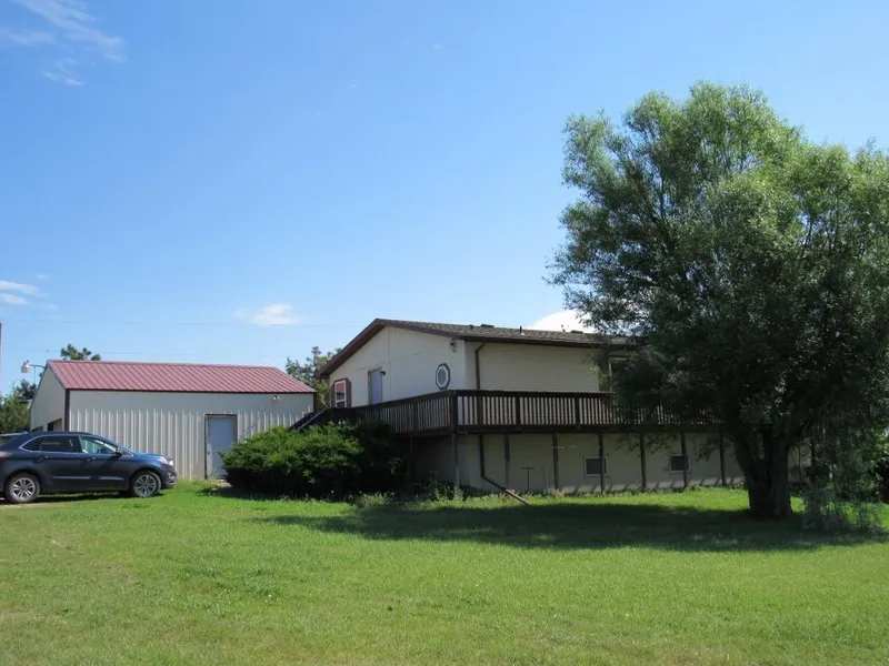
The Box Butte Creek Ranch was once a unit of a larger operation that included a commercial cow herd, stocker/feeder grazing and hay/forage production. The land is situated in west central Sheridan County, only 18 miles south of Hay Springs, NE or 20 miles north of Alliance, NE with the location taking advantage of the Mirage Flats Irrigation District and its ability to produce an abundant amount of livestock feed. The improvements are protected and look over Box Butte Creek and the sub-irrigated hay meadows. 942 Deeded Acres +/- plus 320 Leased Acres +/-. Three - bedroom home, double car garage/workshop, calving shed and corrals. Live tree and metal windbreaks. Ideal for summer grazing, a horse or cow/calf operation, or small-scale livestock production.
All information has been provided by sources deemed reliable, however accuracy is not guaranteed. Prospective buyers are responsible to verify all information to their satisfaction. Offering is subject to approval of purchase by owner, prior sale, price change, correction or withdrawal without notice. There may be variations between the property boundary & the location of existing fences. There may also be variations as to the specific acreage within the boundary of the property. Seller makes no warranties in this regard. Maps are based upon legal description & not to scale. The location of the property boundary & existing fences is approximate. Maps are for visual aid with accuracy not guaranteed.
NOTE: To confirm a showing, financial verification is required. Thank You
Western View Real Estate
From elevation to risk assessment
Search for detailed parcel information including; Elevation & Vegetation Maps, Ownership Information, Detailed Parcel Information, Crop History Map, Soil Survey Productivity Data, and more.
Research Parcel InformationEnvironmental Factors
Sheridan County Properties By Type
- Ranches for Sale in Sheridan County, Nebraska
- Farms for Sale in Sheridan County, Nebraska
- Hunting Land for Sale in Sheridan County, Nebraska
- Commercial Property for Sale in Sheridan County, Nebraska
- Riverfront Property for Sale in Sheridan County, Nebraska
- Residential Property for Sale in Sheridan County, Nebraska
- Recreational Property for Sale in Sheridan County, Nebraska
- Horse Property for Sale in Sheridan County, Nebraska
- Undeveloped Land for Sale in Sheridan County, Nebraska
- Timberland for Sale in Sheridan County, Nebraska
- Lakefront Property for Sale in Sheridan County, Nebraska
- Beachfront Property for Sale in Sheridan County, Nebraska
Properties for Sale Nearby Counties
Sheridan County Properties By City
- Bingham, Nebraska Land for Sale
- Ellsworth, Nebraska Land for Sale
- Gordon, Nebraska Land for Sale
- Hay Springs, Nebraska Land for Sale
- Lakeside, Nebraska Land for Sale
- Rushville, Nebraska Land for Sale
- Whiteclay, Nebraska Land for Sale
- Antioch, Nebraska Land for Sale
- Clinton, Nebraska Land for Sale
- Hoffland, Nebraska Land for Sale
- Pine Ridge, Nebraska Land for Sale