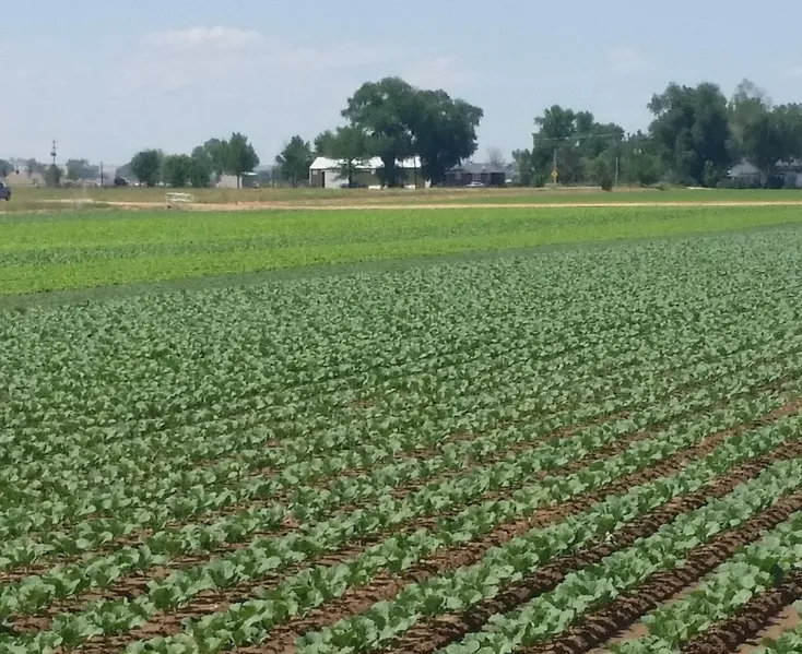
Irrigated Farmland
+/- 127 acres, 116 of which is farmland, located Southwest of Platteville, CO. The property lies along County Road 21 1/2 between County Road 24 1/2 and County Road 26.
Located in part of Northeast of Section 2 of Township 2 North, Range 67 West.
2014 Taxes = $1,106.64.
There is an irrigation well augmented by Central with an 8.33 AF pumping quota for 2015. There is an agreement with Castle Pines to lease 7 Shares of the Meadow Island Irrigation Company and 1 Share of the Lupton Bottom Ditch effective on January 1, 2015 through December 31, 2016. This lease may be renewed for a maximum of three successive one-year periods upon expiration of the initial lease term.
From elevation to risk assessment
Search for detailed parcel information including; Elevation & Vegetation Maps, Ownership Information, Detailed Parcel Information, Crop History Map, Soil Survey Productivity Data, and more.
Research Parcel InformationDirections
From Platteville take Hwy 85 South about 1 mile to County Road 28. Take County Road 28 West about two miles to County Road 21 1/2. Take County Road 21 South for 1 mile. The property is on the east side of CR 21 1/2. Signs will be posted.
Environmental Factors
Resources
Land for Sale by Ryan Hostetler
Weld County Properties By Type
- Undeveloped Land for Sale in Weld County, Colorado
- Farms for Sale in Weld County, Colorado
- Ranches for Sale in Weld County, Colorado
- Residential Property for Sale in Weld County, Colorado
- Lakefront Property for Sale in Weld County, Colorado
- Horse Property for Sale in Weld County, Colorado
- Commercial Property for Sale in Weld County, Colorado
- Riverfront Property for Sale in Weld County, Colorado
- Hunting Land for Sale in Weld County, Colorado
- Timberland for Sale in Weld County, Colorado
- Recreational Property for Sale in Weld County, Colorado
- Beachfront Property for Sale in Weld County, Colorado
Properties for Sale Nearby Counties
- Adams County, Colorado Land for Sale
- Boulder County, Colorado Land for Sale
- Broomfield County, Colorado Land for Sale
- Kimball County, Colorado Land for Sale
- Laramie County, Colorado Land for Sale
- Larimer County, Colorado Land for Sale
- Logan County, Colorado Land for Sale
- Morgan County, Colorado Land for Sale
Weld County Properties By City
- Ault, Colorado Land for Sale
- Briggsdale, Colorado Land for Sale
- Carr, Colorado Land for Sale
- Dacono, Colorado Land for Sale
- Eaton, Colorado Land for Sale
- Erie, Colorado Land for Sale
- Evans, Colorado Land for Sale
- Firestone, Colorado Land for Sale
- Fort Lupton, Colorado Land for Sale
- Frederick, Colorado Land for Sale
- Galeton, Colorado Land for Sale
- Gilcrest, Colorado Land for Sale
- More
- Gill, Colorado Land for Sale
- Greeley, Colorado Land for Sale
- Grover, Colorado Land for Sale
- Hereford, Colorado Land for Sale
- Hudson, Colorado Land for Sale
- Johnstown, Colorado Land for Sale
- Keenesburg, Colorado Land for Sale
- Kersey, Colorado Land for Sale
- La Salle, Colorado Land for Sale
- Lucerne, Colorado Land for Sale
- Mead, Colorado Land for Sale
- Milliken, Colorado Land for Sale
- New Raymer, Colorado Land for Sale
- Nunn, Colorado Land for Sale
- Pierce, Colorado Land for Sale
- Platteville, Colorado Land for Sale
- Roggen, Colorado Land for Sale
- Severance, Colorado Land for Sale
- Stoneham, Colorado Land for Sale
- Windsor, Colorado Land for Sale
- Garden City, Colorado Land for Sale
- Raymer, Colorado Land for Sale
- Adna, Colorado Land for Sale
- Alden, Colorado Land for Sale
- Auburn, Colorado Land for Sale
- Avalo, Colorado Land for Sale
- Barnesville, Colorado Land for Sale
- Bracewell, Colorado Land for Sale
- Bruce, Colorado Land for Sale
- Buckingham, Colorado Land for Sale
- Buda, Colorado Land for Sale
- Bunyan, Colorado Land for Sale
- Canton, Colorado Land for Sale
- Cloverly, Colorado Land for Sale
- Comer, Colorado Land for Sale
- Cornish, Colorado Land for Sale
- Dearfield, Colorado Land for Sale
- Dent, Colorado Land for Sale
- Dick, Colorado Land for Sale
- Dover, Colorado Land for Sale
- East La Salle, Colorado Land for Sale
- Elm, Colorado Land for Sale
- Elwell, Colorado Land for Sale
- Evanston, Colorado Land for Sale
- Farmers, Colorado Land for Sale
- Fosston, Colorado Land for Sale
- Gates, Colorado Land for Sale
- Gowanda, Colorado Land for Sale
- Greeley Junction, Colorado Land for Sale
- Hambert, Colorado Land for Sale
- Hardin, Colorado Land for Sale
- Hardman, Colorado Land for Sale
- Harney, Colorado Land for Sale
- Highland Lake, Colorado Land for Sale
- Hillsboro, Colorado Land for Sale
- Houston, Colorado Land for Sale
- Hurrich, Colorado Land for Sale
- Idaho Creek, Colorado Land for Sale
- Jackson Field, Colorado Land for Sale
- Jessum, Colorado Land for Sale
- Johnson, Colorado Land for Sale
- Kahler, Colorado Land for Sale
- Keota, Colorado Land for Sale
- Kirkland, Colorado Land for Sale
- Krauss, Colorado Land for Sale
- Kuner, Colorado Land for Sale
- Lowe, Colorado Land for Sale
- Maloy, Colorado Land for Sale
- Mason Corner, Colorado Land for Sale
- Masters, Colorado Land for Sale
- Matthews, Colorado Land for Sale
- Mumper Corner, Colorado Land for Sale
- Peckham, Colorado Land for Sale
- Plumbs, Colorado Land for Sale
- Powars, Colorado Land for Sale
- Prospect Valley, Colorado Land for Sale
- Pulliam, Colorado Land for Sale
- Purcell, Colorado Land for Sale
- Puritan, Colorado Land for Sale
- Rinn, Colorado Land for Sale
- Rockport, Colorado Land for Sale
- Rosedale, Colorado Land for Sale
- Roy, Colorado Land for Sale
- Saint Vrains, Colorado Land for Sale
- Sloan, Colorado Land for Sale
- South Roggen, Colorado Land for Sale
- Spanish Village, Colorado Land for Sale
- Stage, Colorado Land for Sale
- Tampa, Colorado Land for Sale
- Tonville, Colorado Land for Sale
- Vollmar, Colorado Land for Sale
- Walker, Colorado Land for Sale
- Warren, Colorado Land for Sale
- Wattenberg, Colorado Land for Sale
- Welty, Colorado Land for Sale
- Wildcat, Colorado Land for Sale