Quiet 0.37 Acres of Flat, Peaceful Arkansas Woods
Owner Financing:
- $79 down (plus the $249 doc fee)
- $79 down $79/Mo for 48 months (plus prorated taxes and note maintenance fee)
Flat, Private 0.37-Acre Forest Retreat in Arkansas
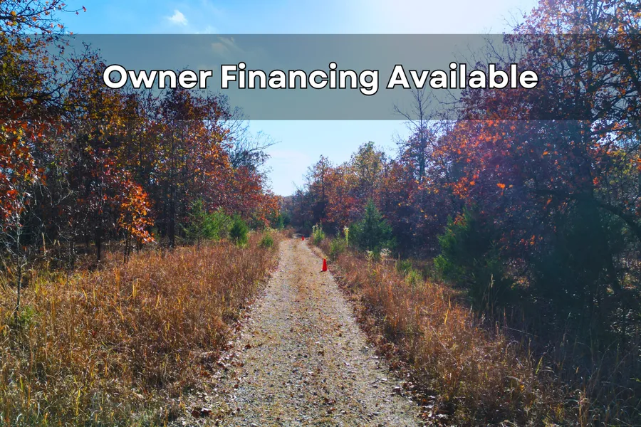
When life feels loud or overwhelming, having a quiet place to escape to can make everything feel lighter. This 0.37-acre parcel in Izard County, Arkansas offers that kind of steady peace. The first thing youll notice is the flat, level terrainan uncommon feature for wooded land in this region. Its easy to walk, easy to enjoy, and instantly comfortable under your feet. Paired with its quiet forest setting, it creates a calm place where the pace naturally slows down.
The property sits within a stretch of tall hardwoods, tucked off Sunset Circle Dr in a peaceful part of the county. Here, the sound of wind through the trees comes before anything else. Mature oaks create a soft canopy that brings a mix of shade and light throughout the day. The forest floor is covered in natural leaves and soft ground cover, giving the entire parcel a gentle, inviting feel. Nothing about the land is harshit has a natural ease that encourages you to take your time.
As you explore the property, the stillness stands out. There are no nearby structures, giving you open forest views and full privacy. The land is fully off-grid, which helps keep the setting quiet and untouched. You can move through the trees without interruption or noise. It feels like your own private corner of forestsomewhere you can step into and let everything else fade away.
Getting to the property follows that same relaxed pace. The access road is a rustic dirt path that keeps the area peaceful by limiting traffic. The road has a few soft spots, so a high-clearance or 4x4 vehicle helps keep travel smooth. This slower, quieter access helps preserve the calm that defines this entire wooded area.
Even with all the privacy, the land sits just 5 miles (about 10 minutes) from Horseshoe Bend. This small Arkansas town gives you simple conveniencesgroceries, gas, and a few local shopswithout taking away the quiet feel of your property. You can pick up supplies and return to the trees in minutes.
The surrounding area offers peaceful outdoor spots perfect for easy days outside. Box Hound Marina Resort & RV Park is only 10 minutes away and provides calm shoreline views along Crown Lake. About 30 minutes from the property, Griffin Park RV Park & Campground stretches along the river in a wide, wooded setting. The Turkey Pen Shooting Range, also around 30 minutes away, sits within a broad natural area. These spots add variety while keeping the region peaceful and slow-paced.
Back on the land, the forest is the main feature. The flat terrain makes each step simple. You can walk between the trees, explore shaded areas, or pause in natural openings where the light filters through. Soft leaves cover the ground, and the light shifts gently between the trees as you walk, making the whole parcel feel calm and steady. The land doesnt overwhelm or demand anything. It simply gives you spaceroom to breathe and recharge at your own pace.
Aerial views of Izard County reveal long stretches of forest, with layers of green in summer, warm color in fall, and open, branch-lined views in winter. Your parcel sits within that broad landscape, surrounded by forest in every direction. Owning a piece of land in a setting like this offers a sense of steadiness. It gives you a place that stays quiet and grounded even when life moves fast.
Walking this property is easy because the ground remains level throughout. You dont need to climb hills or push through heavy brush. Natural openings appear between the trees, creating simple pathways to explore. The forest floor absorbs sound, making each step soft and quiet. From any angle, the land feels peaceful.
One of the strongest qualities of this parcel is the privacy. With no nearby homes and no active roads close by, the land feels tucked away in a quiet section of forest. This level of privacy is uncommon in this price range, especially on flat, usable ground. Whether you plan to visit often or keep the land as a long-term retreat, it remains a place where quiet moments are always waiting.
Despite the peaceful setting, ownership is simple. With just $79 down, this 0.37-acre off-grid parcel becomes yours. Theres no pressure, no confusing terms, and no crowded neighborhoodsjust a straightforward way to secure a calm, steady place in the woods. Whether you want a personal getaway or simply a piece of land that stays still when life doesnt, this property offers that grounding feeling.
If youve been searching for a small piece of forest where you can slow down, breathe easier, and enjoy nature without noise or rush, this Izard County parcel is a rare find. It offers flat terrain, privacy, trees, and quick access to a friendly town and peaceful outdoor spots. Everything about it supports a quieter pace.
This land gives you something steadya quiet place you can return to whenever you want a break from the world.
PROPERTY DETAILS
Location: Izard County, Arkansas
Size: 0.37 acres
Terrain: Flat and level
Setting: Hardwood forest with natural shade
Road Access: Rustic dirt road via Sunset Circle Dr
Vehicle Needs: High-clearance or 4x4 recommended
Utilities: None fully off-grid
Nearest Town: Horseshoe Bend (5 miles / ~10 minutes)
Down Payment: $79
NEARBY ATTRACTIONS
Box Hound Marina Resort & RV Park 10 minutes
Griffin Park RV Park & Campground 30 minutes
Turkey Pen Shooting Range 30 minutes
WHY THIS LAND STANDS OUT
Flat, easy-to-walk terrain
Deep forest privacy
No nearby homes or noise
Natural shade and gentle forest setting
Close to town yet tucked away
Surrounded by hardwood forest
A peaceful place to recharge
Calm land at an accessible price
SIMPLE, FRIENDLY OWNERSHIP
Easy process
Clear terms
$79 down to secure
No pressure
Help available whenever needed
State: AR
County: Izard
Zip: 72512
Size: 0.37 acres
Apn: 80006075000
Legal Description: Lot 634, HILLCREST ADDITION, HORSESHOE BEND ESTATES, a Subdivision in Izard County, Arkansas, as the same is shown and designated on the
plat of same filed in the office of the County Clerk of Izard County, Arkansas, on the 7th day of February, 1972, and subject to road and utility easements; as well as all mineral reservations of record, if any, of previous grantors in the chain of title.
Lat/Long Coordinates:
Nw: 36.235488, -91.699415
Ne: 36.235714, -91.699282
Sw: 36.235319, -91.698881
Se: 36.235520, -91.698783
Elevation: 822 feet
Annual Taxes: Approx. $15 per year
Zoning: Residential Property, Recreational Property, Undeveloped Land
Flood Zone: No
HOA/POA: No
Improvements: No improvements done.
Access: Dirt Road
Water: Will need to install a Well
Sewer: Will need to install a Septic System
Utilities: Utilities Available nearby
Owner Financing:
- $79 down (plus the non refundable doc fee of $249)
$79 down $79/Mo for 48 months (plus prorated taxes and note maintenance fee)
We do not offer owner financing for residential use or full-time living on the property during the financing term.
From elevation to risk assessment
Search for detailed parcel information including; Elevation & Vegetation Maps, Ownership Information, Detailed Parcel Information, Crop History Map, Soil Survey Productivity Data, and more.
Research Parcel InformationDirections
From Little Rock, Arkansas, USA to 1306 Senate Dr, Horseshoe Bend, AR 72512, USA
-Get on I-630 E 2 min (0.3 mi)
-Head north toward W 8th St 131 ft
-Turn right at the 1st cross street onto W 8th St 0.2 mi
-Use any lane to take the ramp onto I-630 E 0.1 mi
-Follow I-57/US-167 N/US-67 N to W Main St in Ash Flat 2 hr 13 min (131 mi)
-Merge onto I-630 E 1.4 mi
-Use the left 2 lanes to take exit 139A-139B for I-30 E toward N Little Rock 0.4 mi
-Keep left and merge onto I-30 E 2.8 mi
-Use the right 2 lanes to take exit 143B to merge onto I-40 E/US-167 N/US-67 N toward Jacksonville/Memphis 1.6 mi
-Use the left 2 lanes to take exit 155 for US-67/US-167 N toward Jacksonville/L.R.A.F.B 0.6 mi
-Continue onto I-57/US-167 N/US-67 N 54.4 mi
-Take exit 55 for US-64 E/US-167 N toward Bald Knob/Batesville 0.3 mi
-Slight left onto the US-167 N ramp 108 ft
-Turn left onto US-167 N/US-64 W
-Continue to follow US-167 N
-Pass by Taco Bell (on the left in 33.5 mi) 70.0 mi
-Follow Peace Valley Rd, Day Rd and Peaceful Hollow Dr to E Forest Hills Cir in Horseshoe Bend 14 min (8.4 mi)
-Turn left onto W Main St 0.1 mi
-Continue onto Peace Valley Rd 2.1 mi
-Slight right to stay on Peace Valley Rd 3.0 mi
-Peace Valley Rd turns slightly left and becomes Day Rd 1.7 mi
-Turn left onto N Pine Ridge Dr 0.3 mi
-Turn left onto Peaceful Hollow Dr 1.1 mi
-Turn right onto E Forest Hills Cir 95 ft
-Slight left to stay on E Forest Hills Cir
-Destination will be on the left 0.1 mi
Resources
Land for Sale by Chris Palsgrove
Izard County Properties By Type
- Undeveloped Land for Sale in Izard County, Arkansas
- Hunting Land for Sale in Izard County, Arkansas
- Farms for Sale in Izard County, Arkansas
- Riverfront Property for Sale in Izard County, Arkansas
- Lakefront Property for Sale in Izard County, Arkansas
- Ranches for Sale in Izard County, Arkansas
- Residential Property for Sale in Izard County, Arkansas
- Timberland for Sale in Izard County, Arkansas
- Recreational Property for Sale in Izard County, Arkansas
- Horse Property for Sale in Izard County, Arkansas
- Commercial Property for Sale in Izard County, Arkansas
- Beachfront Property for Sale in Izard County, Arkansas
Properties for Sale Nearby Counties
Izard County Properties By City
- Brockwell, Arkansas Land for Sale
- Calico Rock, Arkansas Land for Sale
- Dolph, Arkansas Land for Sale
- Franklin, Arkansas Land for Sale
- Guion, Arkansas Land for Sale
- Horseshoe Bend, Arkansas Land for Sale
- Melbourne, Arkansas Land for Sale
- Mount Pleasant, Arkansas Land for Sale
- Oxford, Arkansas Land for Sale
- Pineville, Arkansas Land for Sale
- Sage, Arkansas Land for Sale
- Violet Hill, Arkansas Land for Sale
- More
- Wideman, Arkansas Land for Sale
- Wiseman, Arkansas Land for Sale
- Boswell, Arkansas Land for Sale
- Forty Four, Arkansas Land for Sale
- Jordan, Arkansas Land for Sale
- Zion, Arkansas Land for Sale
- Band Mill, Arkansas Land for Sale
- Belview, Arkansas Land for Sale
- Bone Town, Arkansas Land for Sale
- Brandenburg, Arkansas Land for Sale
- Creswell, Arkansas Land for Sale
- Crocker, Arkansas Land for Sale
- Crossroads, Arkansas Land for Sale
- Day, Arkansas Land for Sale
- Gid, Arkansas Land for Sale
- Gorby, Arkansas Land for Sale
- Iuka, Arkansas Land for Sale
- Jumbo, Arkansas Land for Sale
- Knob Creek, Arkansas Land for Sale
- LaCrosse, Arkansas Land for Sale
- Lafferty, Arkansas Land for Sale
- Larkin, Arkansas Land for Sale
- Lunenburg, Arkansas Land for Sale
- Myersville, Arkansas Land for Sale
- Myron, Arkansas Land for Sale
- Nasco, Arkansas Land for Sale
- New Liberty, Arkansas Land for Sale
- Newburg, Arkansas Land for Sale
- Stella, Arkansas Land for Sale
- Sylamore, Arkansas Land for Sale
- Twin Bridges, Arkansas Land for Sale
- Twin Creek, Arkansas Land for Sale
- Wolquarry, Arkansas Land for Sale
