13261 NE 100th, Red Oak, OK 74563 - Latimer County
Little Ridge to Fourche
Description
LITTLE RIDGE to FOURCHE
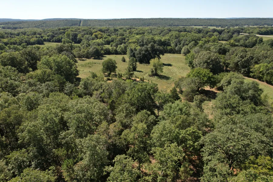
Combo property with a homestead on a ridge looking at the Ouachitas to the south and the Sans Bois to the north. Deer-turkey-hog-small game hunting on or close by, fishing on Fourche Maline Creek running entire south side of property.
LOCATION: Located in Latimer County, Southeast Oklahoma, approximately 3 miles south of Red Oak, just over 10 miles north of Talihina. Approximately 3 hours from DFW, 2 hours from Tulsa, and just over an hour drive from Ft. Smith, Ark.. This area is the home of numerous lakes and recreation points, including the Ouachita National Forest to the south.
SITE: 55 acres m/l combo property, from the ridge on the north, down to the open meadows on Fourche to the south. Estimate presently 45% open/pasture, balance wooded, mainly mature hardwoods. Soil and topo maps available maps available.
IMPROVEMENTS: 3br, 2.5 bath dwelling built in 2008. Rustic wood siding, metal roof, complete wrap-a-round porch, safe room, electric r/o, dw, built in micro-wave. CH/AC as well as a wood burning stove.
ACCESS: County road mile east of SH 83..
UTILITIES: Electric, phone, propane and rural water.
USAGE: Cattle, equine, recreation, hunting, fishing, rv.
WILDLIFE: Great area for deer, turkey, hog, small game. Strong evidence of deer and small game onsite. Fishing in the live creek on the south as well as lakes in the area.
WATER: 1 pond, Fourche Maline Creek, a live year-round water source.
COMMENTS: A very well-located property in the valley between the mountains. Great access, excellent potential to develop into a private retreat or combo estate. Run a few cattle or horses, a little hunting or fishing, a lot of relaxing. Probably find you some artifacts on the creek from the first occupants. Give us a call!
From elevation to risk assessment
Search for detailed parcel information including; Elevation & Vegetation Maps, Ownership Information, Detailed Parcel Information, Crop History Map, Soil Survey Productivity Data, and more.
Research Parcel InformationDirections
3 miles south of Red Oak on SH 83
Environmental Factors
Latimer County Properties By Type
- Undeveloped Land for Sale in Latimer County, Oklahoma
- Hunting Land for Sale in Latimer County, Oklahoma
- Timberland for Sale in Latimer County, Oklahoma
- Ranches for Sale in Latimer County, Oklahoma
- Riverfront Property for Sale in Latimer County, Oklahoma
- Residential Property for Sale in Latimer County, Oklahoma
- Farms for Sale in Latimer County, Oklahoma
- Recreational Property for Sale in Latimer County, Oklahoma
- Lakefront Property for Sale in Latimer County, Oklahoma
- Horse Property for Sale in Latimer County, Oklahoma
- Commercial Property for Sale in Latimer County, Oklahoma
- Beachfront Property for Sale in Latimer County, Oklahoma
Properties for Sale Nearby Counties
Latimer County Properties By City
- Gowen, Oklahoma Land for Sale
- Panola, Oklahoma Land for Sale
- Red Oak, Oklahoma Land for Sale
- Wilburton, Oklahoma Land for Sale
- Higgins, Oklahoma Land for Sale
- Bengal, Oklahoma Land for Sale
- Bowers, Oklahoma Land for Sale
- Cedar, Oklahoma Land for Sale
- Center Point, Oklahoma Land for Sale
- Chilli, Oklahoma Land for Sale
- Damon, Oklahoma Land for Sale
- Degnan, Oklahoma Land for Sale
- More