1311 & 1203 N State Route 291 Highway, Liberty, MO 64068 - Clay County
Is this your property? Sell it faster with premium placement and targeted ads.
COMMERCIAL - Liberty, MO
Description
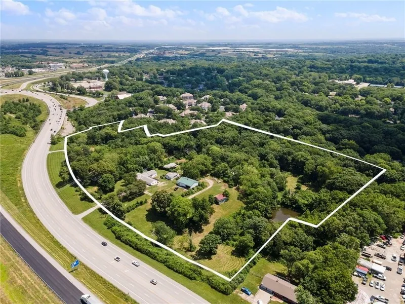
Positioned at the crossroads of visibility and velocity, this nearly 15-acre property offers one of the most strategic commercial development sites in Liberty, Missouri. Located just off the I-35 and 291 Hwy interchange, this high-traffic corridor sees thousands of daily commuters and is a vital link to the booming Northland region. This is your opportunity to capitalize on a prime corridor between two of Liberty's most active and in-demand commercial zones between 152 and 291-positioning your project right where growth is heading. Currently zoned residential, all three parcels lie within Liberty's comprehensive plan for future commercial zoning-making this a rare chance to get ahead of the curve. Whether you're planning a retail hub, mixed-use development, corporate campus, or medical facility, this location offers the accessibility and visibility developers dream about. Key Highlights: 14.96 acres (combined) of wooded and partially cleared land Direct frontage along 291 Hwy with immediate access to I-35 Flat topography ideal for development Within minutes of major commercial centers, national retailers, and residential neighborhoods Area already experiencing major business expansion and infrastructure investment City of Liberty has future plans for commercial zoning Utilities available at site With explosive growth throughout Clay County and Liberty's pro-business development plans, this is more than just land-it's a launchpad for your next big project.
Copyright © 2026 Heartland Multiple Listing Service. All rights reserved. All information provided by the listing agent/broker is deemed reliable but is not guaranteed and should be independently verified.
From elevation to risk assessment
Search for detailed parcel information including; Elevation & Vegetation Maps, Ownership Information, Detailed Parcel Information, Crop History Map, Soil Survey Productivity Data, and more.
Research Parcel InformationIs this your property? Sell it faster with premium placement and targeted ads.
Clay County Properties By Type
- Farms for Sale in Clay County, Missouri
- Hunting Land for Sale in Clay County, Missouri
- Undeveloped Land for Sale in Clay County, Missouri
- Residential Property for Sale in Clay County, Missouri
- Ranches for Sale in Clay County, Missouri
- Commercial Property for Sale in Clay County, Missouri
- Lakefront Property for Sale in Clay County, Missouri
- Timberland for Sale in Clay County, Missouri
- Horse Property for Sale in Clay County, Missouri
- Recreational Property for Sale in Clay County, Missouri
- Beachfront Property for Sale in Clay County, Missouri
- Riverfront Property for Sale in Clay County, Missouri
Properties for Sale Nearby Counties
Clay County Properties By City
- Excelsior Springs, Missouri Land for Sale
- Holt, Missouri Land for Sale
- Kearney, Missouri Land for Sale
- Liberty, Missouri Land for Sale
- Missouri City, Missouri Land for Sale
- Mosby, Missouri Land for Sale
- Smithville, Missouri Land for Sale
- Avondale, Missouri Land for Sale
- Birmingham, Missouri Land for Sale
- Claycomo, Missouri Land for Sale
- Crystal Lakes, Missouri Land for Sale
- Gladstone, Missouri Land for Sale
- More
- North Kansas City, Missouri Land for Sale
- Oakview, Missouri Land for Sale
- Paradise, Missouri Land for Sale
- Pleasant Valley, Missouri Land for Sale
- Prathersville, Missouri Land for Sale
- Randolph, Missouri Land for Sale
- Wood Heights, Missouri Land for Sale
- Acme, Missouri Land for Sale
- Arley, Missouri Land for Sale
- Barry, Missouri Land for Sale
- Chandler, Missouri Land for Sale
- Claysville, Missouri Land for Sale
- Clevenger, Missouri Land for Sale
- Coopers, Missouri Land for Sale
- Crescent Lake, Missouri Land for Sale
- East Kansas City, Missouri Land for Sale
- Ectonville, Missouri Land for Sale
- Evanston, Missouri Land for Sale
- Excelsior Springs Junction, Missouri Land for Sale
- Gashland, Missouri Land for Sale
- Glenaire, Missouri Land for Sale
- Harlem, Missouri Land for Sale
- Maple Garden, Missouri Land for Sale
- Maple Park, Missouri Land for Sale
- Miltondale, Missouri Land for Sale
- Minneville, Missouri Land for Sale
- Moscow, Missouri Land for Sale
- Nashua, Missouri Land for Sale
- Oaks, Missouri Land for Sale
- Oakwood Manor, Missouri Land for Sale
- Oakwood Park, Missouri Land for Sale
- Ravena Gardens, Missouri Land for Sale
- Roosterville, Missouri Land for Sale
- South Liberty, Missouri Land for Sale
- Stockdale, Missouri Land for Sale
- Thomas Heights, Missouri Land for Sale
- Thornton, Missouri Land for Sale
- White Hall Fields, Missouri Land for Sale
- Winner, Missouri Land for Sale
- Winnetonka, Missouri Land for Sale
- Winnwood, Missouri Land for Sale
- Winnwood Gardens, Missouri Land for Sale
- Woodhill, Missouri Land for Sale