140+/- ac Buckhorn East Pines Tract
Description
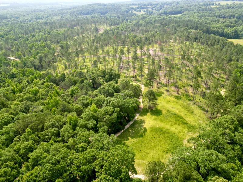
Property Highlights:
* Creek running through the property with a potential pond site
* Five established food plots supporting active wildlife management
* Professionally managed timber with Loblolly pines and hardwood bottoms
* Internal road system and newly dressed fire lanes
This 140 acre property is located in the Buckhorn community of Pike County, Alabama, an area known for its rural character and recreational appeal. Buckhorn has long been known for producing exceptional whitetail and turkey populations, and this property is no exception. The land features a creek that runs horizontally through the center, providing a natural water source with a potential pond site. The surrounding area is made up of larger landholdings and low-density development, ensuring a quiet and private setting with minimal disruption. The property has been actively managed through timber thinning and prescribed burning to improve visibility and promote native forage growth, supporting a natural habitat for wildlife. There are five established food plots throughout the tract, offering opportunities for continued wildlife management or recreational use. The property features a network of well-maintained internal roads and trails, along with newly dressed fire lanes. The property has Lobolley Pines and Hardwood bottoms. This property has strong potential to become a prime quail habitat. The existing mix of open understory, native grasses, and manageable timber structure provides a solid foundation for upland bird management and habitat development. Access to the property is convenient, with frontage along a well-maintained county road and its location just 12 miles from Troy, Alabama.
Additional acreage is available for purchase.
Properties of this quality, size, and location in the Buckhorn community rarely come to market and are highly sought after.
From elevation to risk assessment
Search for detailed parcel information including; Elevation & Vegetation Maps, Ownership Information, Detailed Parcel Information, Crop History Map, Soil Survey Productivity Data, and more.
Research Parcel InformationDirections
From HWY 29 N, turn left on HWY 130. In 1.9 miles, turn left on County Road 6651. After 0.3 miles, turn right on County Road 6650. The property will be on the right in 0.5 miles.
Environmental Factors
Resources
Pike County Properties By Type
- Undeveloped Land for Sale in Pike County, Alabama
- Hunting Land for Sale in Pike County, Alabama
- Farms for Sale in Pike County, Alabama
- Ranches for Sale in Pike County, Alabama
- Residential Property for Sale in Pike County, Alabama
- Recreational Property for Sale in Pike County, Alabama
- Riverfront Property for Sale in Pike County, Alabama
- Lakefront Property for Sale in Pike County, Alabama
- Commercial Property for Sale in Pike County, Alabama
- Timberland for Sale in Pike County, Alabama
- Horse Property for Sale in Pike County, Alabama
- Beachfront Property for Sale in Pike County, Alabama
Properties for Sale Nearby Counties
Pike County Properties By City
- Banks, Alabama Land for Sale
- Brundidge, Alabama Land for Sale
- Goshen, Alabama Land for Sale
- Troy, Alabama Land for Sale
- Allred, Alabama Land for Sale
- Ansley, Alabama Land for Sale
- Baltic, Alabama Land for Sale
- Briar Hill, Alabama Land for Sale
- Broad View, Alabama Land for Sale
- Catalpa, Alabama Land for Sale
- China Grove, Alabama Land for Sale
- Colina, Alabama Land for Sale
- More
- College Park, Alabama Land for Sale
- Corcoran, Alabama Land for Sale
- Dogwood Acres, Alabama Land for Sale
- Dunn, Alabama Land for Sale
- Elmhill Plantation, Alabama Land for Sale
- Enon, Alabama Land for Sale
- Ezell, Alabama Land for Sale
- Forest Circle, Alabama Land for Sale
- Friendship, Alabama Land for Sale
- Green Oaks, Alabama Land for Sale
- Green Ridge, Alabama Land for Sale
- Hallsville, Alabama Land for Sale
- Hamilton Crossroads, Alabama Land for Sale
- Hephzibah, Alabama Land for Sale
- Heritage Ridge, Alabama Land for Sale
- Highland Park, Alabama Land for Sale
- Hillcrest, Alabama Land for Sale
- Joquin, Alabama Land for Sale
- Josie, Alabama Land for Sale
- Lees Park, Alabama Land for Sale
- Lewis, Alabama Land for Sale
- Linwood, Alabama Land for Sale
- Little Oak, Alabama Land for Sale
- Logton, Alabama Land for Sale
- McClure Town, Alabama Land for Sale
- Meadow Grove, Alabama Land for Sale
- Meeksville, Alabama Land for Sale
- Monticello, Alabama Land for Sale
- Mossy Grove, Alabama Land for Sale
- Mossy Grove Village, Alabama Land for Sale
- Mountainbrook, Alabama Land for Sale
- Northdale, Alabama Land for Sale
- Oaks Heights, Alabama Land for Sale
- Olustee, Alabama Land for Sale
- Orion, Alabama Land for Sale
- Pronto, Alabama Land for Sale
- Richland, Alabama Land for Sale
- Ridgewood, Alabama Land for Sale
- River Ridge, Alabama Land for Sale
- Saco, Alabama Land for Sale
- Sanders Hill, Alabama Land for Sale
- Sandfield, Alabama Land for Sale
- Shellhorn, Alabama Land for Sale
- Stills Crossroads, Alabama Land for Sale
- Tarentum, Alabama Land for Sale
- Tennille, Alabama Land for Sale
- Thomas Crossroad, Alabama Land for Sale
- Trojan Terrace, Alabama Land for Sale
- Westview, Alabama Land for Sale
- Windmill Hills, Alabama Land for Sale
- Wingard, Alabama Land for Sale
- Woodland Hills, Alabama Land for Sale
- Youngblood, Alabama Land for Sale