Auction Information

146.3 acres in Marshall County, Kansas
146.3 +/- Acres Marshall County Cropland
Friday October 4th 10:00AM at Helvering Center Marysville Kansas
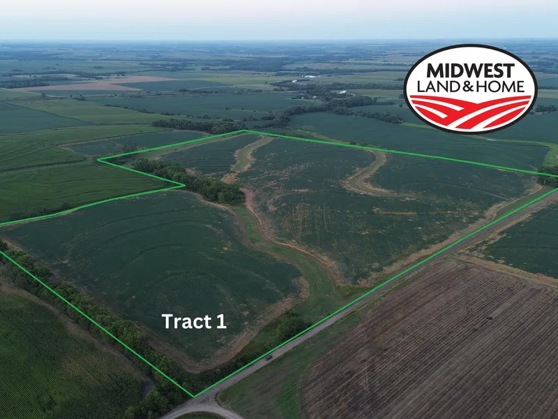
Tract 1 Legal Description: S18, T02, R07, Acres 106.8, SW4 SW4 & E2 SW4 LESS R/W(Per Marshall County Appraisers Office)
Property Features:
Investor Quality Cropland
83% in Crop Production (88.26 Acres)
92% Wymore Silty Clay Loam Class II Soil Type
FSA Details: (ESTIMATED)
107.23 Farmland Acres 98.81 DCP Cropland Acres
86.42 Base Acres (28.87 Beans, 28.63 Wheat, 24.02 Sorghum, 4.9 Corn)
Tract 2 Legal Description: S19, T02, R07, Acres 39.5, NE4 NW4 LESS R/W (Per Marshall County Appraisers Office)
Property Features:
Investor Quality Cropland
89% in Crop Production (88.26 Acres)
100% Wymore Silty Clay Loam Soil Type
(Class II&III)
FSA Details: (ESTIMATED)
39.1 Farmland Acres 39.1 DCP Cropland Acres
34.28 Base Acres (11.45 Beans, 11.36 Wheat, 9.53 Sorghum, 1.94 Corn)
From elevation to risk assessment
Search for detailed parcel information including; Elevation & Vegetation Maps, Ownership Information, Detailed Parcel Information, Crop History Map, Soil Survey Productivity Data, and more.
Research Parcel InformationDirections
From Marysville (Highway 36 & Highway 77 Intersection)travel west 1.5 miles 7th Road. Turn north on 7th Road and travel 2 miles north to Indian Road. Tract 1 is located on the northeast of the 7th Road & Indian Road Intersection. Tract 2 is located 1/4 mile east on south side of Indian Road. LOOK FOR SIGNS!
Environmental Factors
Resources
Land for Sale by Jeff Dankenbring
Marshall County Properties By Type
- Ranches for Sale in Marshall County, Kansas
- Farms for Sale in Marshall County, Kansas
- Recreational Property for Sale in Marshall County, Kansas
- Undeveloped Land for Sale in Marshall County, Kansas
- Hunting Land for Sale in Marshall County, Kansas
- Timberland for Sale in Marshall County, Kansas
- Riverfront Property for Sale in Marshall County, Kansas
- Residential Property for Sale in Marshall County, Kansas
- Commercial Property for Sale in Marshall County, Kansas
- Horse Property for Sale in Marshall County, Kansas
- Lakefront Property for Sale in Marshall County, Kansas
- Beachfront Property for Sale in Marshall County, Kansas
Properties for Sale Nearby Counties
Marshall County Properties By City
- Axtell, Kansas Land for Sale
- Beattie, Kansas Land for Sale
- Blue Rapids, Kansas Land for Sale
- Bremen, Kansas Land for Sale
- Frankfort, Kansas Land for Sale
- Home, Kansas Land for Sale
- Marysville, Kansas Land for Sale
- Oketo, Kansas Land for Sale
- Summerfield, Kansas Land for Sale
- Vermillion, Kansas Land for Sale
- Waterville, Kansas Land for Sale
- Herkimer, Kansas Land for Sale
- More
- Lillis, Kansas Land for Sale
- Vliets, Kansas Land for Sale
- Alcove Spring, Kansas Land for Sale
- Barret, Kansas Land for Sale
- Bestwall, Kansas Land for Sale
- Carden, Kansas Land for Sale
- Cottage Hill, Kansas Land for Sale
- Hermansberg, Kansas Land for Sale
- Lone Elm, Kansas Land for Sale
- Marietta, Kansas Land for Sale
- Nolan, Kansas Land for Sale
- Reedsville, Kansas Land for Sale
- Saint Bridget, Kansas Land for Sale
- Shroyer, Kansas Land for Sale
- Sullivan, Kansas Land for Sale
- Upland, Kansas Land for Sale
- Winifred, Kansas Land for Sale