The Devine Ranch
The Devine Ranch
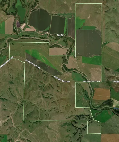
This turnkey operational ranch is in the heart of Central Nebraska. Located in southeast Custer County. From Oconto this property is 3 miles north on Highway 31 and 2.5 miles east on a paved and gravel road. This ranch is only 24 miles south of Broken Bow, 32 miles from Lexington, and 56 miles from Kearney, Nebraska.
Included in this unique ranch is 138.8 acre pivot irrigated farm with mostly class 1 rated soils. There are 1,142 acres of well managed hard land pasture with some being sub-irrigated. There are approximately 179 acres of dry cropland with class 1 and 2 rated soils. There is 9.41 acres of gravity irrigated cropland as well. The bonus on this outstanding ranch is the hunting and recreational opportunities produced by the tree cover and frontage of the South Loup River.
Overall the ranch has been well managed by this generation of owners. The cedar tree population has been controlled. The pasture grazing has been managed well in past years and minimal weed pressure. Water is supplied on the ranch from a stock well located north of Pressey Road. There is underground pipe to the south to three large tire stock tanks providing a good supply of fresh water. There is a non functioning windmill in central west portion of the ranch.
The Devine Ranch is located over the Ogallala Aquifer and is one of the worlds largest aquifers. It is a shallow water table beneath the land and provides fresh water through wells for irrigation and livestock.
Custer County, Nebraska is near several livestock markets including Broken Bow, Lexington, and Kearney. Custer County has the 2nd largest amount of cattle by county in the entire USA. (100,000 head)
Farm information:
138 Acre Pivot Irrigated Crop Land
Electric Well & 50HP Motor, Registration: G-025636, Drilled 7/11/1966, 1,100GPM, Depth 364FT, Static Level 49FT, Pumping Level 103FT, 8 Column.
7 Tower Pivot Owned by the Tenant
FSA Base Acres: 200.30 Acres Corn, 15.60 Acres Soybeans, PLC Yield 121bu. corn and 21bu. beans
Recreational Hunting
Whitetail deer, Mule Deer, Turkey, Waterfowl, Trapping, Fishing
Legal Descriptions:
Northeast & North of the Southeast Quarter of Section 19
Southeast of Section 8
Northwest , North of the South , Southeast of the Southeast in Section 20
South & Northeast of Section 17
Southeast , South of the Northeast , Southeast of the Northwest & Part of Northeast 1/4 of the Southwest and Part North & East of Old Road in Section 18
All in Township 14 North, Range 20 West of the 6th P.M. Custer County, Nebraska
2022 Real Estate Taxes
$21,355.02
All acreages & information are gathered from the Custer County Assessor & Farm Service Agency and not guaranteed by the broker. All map boundaries are for illustrated purposes and not guaranteed.
From elevation to risk assessment
Search for detailed parcel information including; Elevation & Vegetation Maps, Ownership Information, Detailed Parcel Information, Crop History Map, Soil Survey Productivity Data, and more.
Research Parcel InformationResources
Land for Sale by Adam Marshall
Custer County Properties By Type
- Farms for Sale in Custer County, Nebraska
- Ranches for Sale in Custer County, Nebraska
- Commercial Property for Sale in Custer County, Nebraska
- Riverfront Property for Sale in Custer County, Nebraska
- Hunting Land for Sale in Custer County, Nebraska
- Lakefront Property for Sale in Custer County, Nebraska
- Recreational Property for Sale in Custer County, Nebraska
- Undeveloped Land for Sale in Custer County, Nebraska
- Timberland for Sale in Custer County, Nebraska
- Residential Property for Sale in Custer County, Nebraska
- Horse Property for Sale in Custer County, Nebraska
- Beachfront Property for Sale in Custer County, Nebraska
Properties for Sale Nearby Counties
- Blaine County, Nebraska Land for Sale
- Buffalo County, Nebraska Land for Sale
- Dawson County, Nebraska Land for Sale
- Garfield County, Nebraska Land for Sale
- Lincoln County, Nebraska Land for Sale
- Logan County, Nebraska Land for Sale
- Loup County, Nebraska Land for Sale
- Sherman County, Nebraska Land for Sale
- Valley County, Nebraska Land for Sale
Custer County Properties By City
- Anselmo, Nebraska Land for Sale
- Ansley, Nebraska Land for Sale
- Arnold, Nebraska Land for Sale
- Broken Bow, Nebraska Land for Sale
- Callaway, Nebraska Land for Sale
- Comstock, Nebraska Land for Sale
- Mason City, Nebraska Land for Sale
- Merna, Nebraska Land for Sale
- Oconto, Nebraska Land for Sale
- Sargent, Nebraska Land for Sale
- Westerville, Nebraska Land for Sale
- Berwyn, Nebraska Land for Sale
- More
- Milburn, Nebraska Land for Sale
- New Helena, Nebraska Land for Sale
- Weissert, Nebraska Land for Sale
- Buckeye, Nebraska Land for Sale
- Burr Oak, Nebraska Land for Sale
- Cumro, Nebraska Land for Sale
- Etna, Nebraska Land for Sale
- Finchville, Nebraska Land for Sale
- Gates, Nebraska Land for Sale
- Lillian, Nebraska Land for Sale
- Lodi, Nebraska Land for Sale
- Pleasant Hill, Nebraska Land for Sale
- Round Valley, Nebraska Land for Sale
- Walworth, Nebraska Land for Sale
- Wescott, Nebraska Land for Sale