Auction Information
Warren Hutchison Living Trust
151 +/- ACRES OF IRRIGATED CROPLAND: Southwest Quarter (SW/4), Section Twenty Five (Sec. 25), Township Fourteen North (T14N), Range Fourteen West (R14W), Indian Meridian, Custer County, Oklahoma. Surface rights only. Less and except a 9-acre tract located in the Northwest corner.
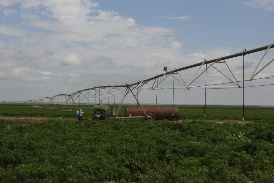
This is a very productive farm. The FSA records show 144.56 acres of cropland with 80.21 acres of wheat base with a 41 bu./A yield and 52.69 acres of grain sorghum with a 39 bu./A yield. The irrigation system consists of a 7 tower Valley pivot that had considerable reconditioning work one year ago. The pivot has drops and rotators. The pump is a 6 turbine pump that is approximately 9 years old and has a 11:10 gearhead. The John Deere 6068, 6 cyl. Diesel engine powers both the pump and a generator to run the pivot. This system has a 3000 gallon fuel tank. The pivot is tipped at 450 G.P.M.
Directions
From Hydro, OK
3 Mi. North on Highway 58, 2 Mi. West, 3 Mi. North,
2 Mi. West to N2440 Rd., 1.5 Mi. North.
From Weatherford, OK
7 Mi. North on Highway 54 to E950 Rd., 4 Mi. East
to N2440 Rd., 1.5 Mi. North
WATCH FOR SIGNS!
GPS Coordinates: 35.656994, -98.645411
Resources
Land for Sale by Roger Entz
Caddo County Properties By Type
- Farms for Sale in Caddo County, Oklahoma
- Commercial Property for Sale in Caddo County, Oklahoma
- Hunting Land for Sale in Caddo County, Oklahoma
- Lakefront Property for Sale in Caddo County, Oklahoma
- Undeveloped Land for Sale in Caddo County, Oklahoma
- Ranches for Sale in Caddo County, Oklahoma
- Riverfront Property for Sale in Caddo County, Oklahoma
- Recreational Property for Sale in Caddo County, Oklahoma
- Residential Property for Sale in Caddo County, Oklahoma
- Horse Property for Sale in Caddo County, Oklahoma
- Timberland for Sale in Caddo County, Oklahoma
- Beachfront Property for Sale in Caddo County, Oklahoma
Properties for Sale Nearby Counties
Caddo County Properties By City
- Albert, Oklahoma Land for Sale
- Anadarko, Oklahoma Land for Sale
- Apache, Oklahoma Land for Sale
- Binger, Oklahoma Land for Sale
- Carnegie, Oklahoma Land for Sale
- Cement, Oklahoma Land for Sale
- Cyril, Oklahoma Land for Sale
- Eakly, Oklahoma Land for Sale
- Fort Cobb, Oklahoma Land for Sale
- Gracemont, Oklahoma Land for Sale
- Hinton, Oklahoma Land for Sale
- Hydro, Oklahoma Land for Sale
- More
- Lookeba, Oklahoma Land for Sale
- Washita, Oklahoma Land for Sale
- Alden, Oklahoma Land for Sale
- Alfalfa, Oklahoma Land for Sale
- Apache Wye, Oklahoma Land for Sale
- Boone, Oklahoma Land for Sale
- Bridgeport, Oklahoma Land for Sale
- Broxton, Oklahoma Land for Sale
- Cogar, Oklahoma Land for Sale
- Hatchetville, Oklahoma Land for Sale
- Indian City, Oklahoma Land for Sale
- Nowhere, Oklahoma Land for Sale
- Pine Ridge, Oklahoma Land for Sale
- Scott, Oklahoma Land for Sale
- Sickles, Oklahoma Land for Sale
- Spring Creek, Oklahoma Land for Sale
- Squaretop, Oklahoma Land for Sale
- Stecker, Oklahoma Land for Sale
- Swan Lake, Oklahoma Land for Sale
- Three-Way Corner, Oklahoma Land for Sale