Auction Information
151.78 acres in Jefferson County, Iowa
Description
Jefferson County Estate Land Auction
Lockridge, Iowa
Located 2 miles north of Lockridge on Vetch Blvd., then east on 195th Street to 3202 195th Street.
Thursday, May 17, 2012 at 4:02 P.M.
Open House on Thursday, May 3 from 4-5pm
** Buyer on Tract #2 receives the 2nd half of the cash rent!
151.78 Acres M/L Sells in Three Tracts
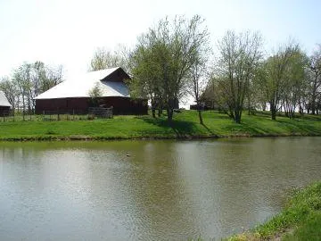
Tract #1 Two Story Home with Pond, Barn on 3.87 Acres M/L
The two story home features 1,472 sq.ft. of living space with three bedrooms. The main level includes a large living room, eat in kitchen, master bedroom and a bath. Upstairs has 2 bedrooms & large closet (could be another bedroom) and walk up floored attic. Other features are a high efficient furnace with central air, enclosed porch with 100 amp breaker box, vinyl siding, & updated septic system in March 2011.
Outbuildings include a 42x46 barn, corn crib & small shed. Pond. Wapello rural water, 2 wells (1 has not been used & 1 is capped)
Located in Sections 22 & 23, Lockridge Township, Jefferson County, Iowa.
Tract #2 77.16 Acres M/L
53.98 acres tillable with balance being pasture & timber.
74.8 CSR on tillable ground 64.1 CSR on entire farm
Nice combination farm with mature walnut trees!
Located in Sections 22 & 23, Lockridge Township, Jefferson County, Iowa.
Tract #3 70.75 Acres M/L
22.7 acres tillable all in CRP at $154.65 per acre, expires 9/30/2021
Balance is timber & pasture
CSR on entire farm is 40
There are 2 wells on the property that are not in use.
Located in Section 23, Lockridge Township, Jefferson County, Iowa.
Not included: LP tank is leased, Appliances, Lawn ornaments, Playground equipment, Gates, Bird houses, Gazebo, All personal property
TERMS: 20% down payment on May 17, 2012 balance to be paid on or before June 15, 2012 upon delivery of merchantable abstract and deed.
POSSESSION: Tract #1 home: June 15, 2012 barn & pasture subject to tenants rights. Tracts #2 & #3 June 15, 2012 subject to tenants rights.
REAL ESTATE TAXES: To be prorated to date of possession on the basis of the last available tax statement. Seller shall pay any unpaid real estate taxes payable in prior years.
The following taxes are approximate and will be used to prorate at closing.
Tract #1
Gross - $453.90
Homestead - $90.20
Net - $363.00 (rounded)
Tract #2
Gross - $1,068.41
Ag. Cr. - $41.77
Net - $1,026.00 (rounded)
Tract #3
Gross - $462.47
Ag. Cr. - $17.33
Net - $445.00 (rounded)
Special Provisions:
Cash Rent on tillable is as follows:
The tillable ground on Tract #2 is rented for the 2012 crop year. The lease is based on $150.00 per acre x 53.98 acres = $8,097.00 and the second half payment of $4,048.50 will be paid by the tenant to the new buyer on November 1, 2012.
Pasture Rent is as follows: The pasture land on Tracts #2 & #3 is rented for the
2012 crop year. Pasture Rent on Tract #2 is based on $35.10 per acre x 20 acres = $702.00. Pasture Rent on Tract #3 is based on #35.10 per acre x 40 acres = $1404.00. Second half of the pasture rent of $351.00 for Tract #2 and $702.00 for Tract #3 will be paid from the tenant to the new buyer(s) on November 1, 2012.
Tract #3 CRP is as follows: 22.7 acres at $154.65 per acre = $3511.00 expires 9/30/2021.
The tenant has been served termination for the 2013 crop year.
Final tillable and CRP acres to be determined by FSA.
It shall be the obligation of the buyer to report to the Jefferson County FSA office and show filed deed in order to receive the following if applicable:
Allotted base acres. B. Any future government programs. C. Prorate of CRP.
Buyer(s) agree to follow all requirements of conservation plans and practices required by the FSA to maintain eligibility in the Conservation Reserve Program. Buyer(s) agree to accept responsibility and liability for any actions by the buyer which would endanger eligibility for the CRP or actions that would require repayment of the CRP payment or payments. Buyer(s) further agree to indemnify and hold harmless the sellers/tenant for any recovery sought by the FSA due to actions of buyer, which would violate the requirements of the CRP. In the event the buyer(s) elect to take the ground out of CRP, the buyer(s) will be responsible to the seller/tenant for any prorate of the CRP payment that the seller/tenant would have received.
The current tenant reserves the right to repair & maintain the water line and receive water from the pond on Tract #1 for livestock use only.
The land has been surveyed by a registered land surveyor.
The buyer of Tract #1 shall reimburse the seller for the remaining gas in the LP gas tank at the current rate on the day of possession.
The buyer(s) shall be responsible for any fencing in accordance with Iowa state law.
Due to this being an estate, the seller will be exempt from all Iowa septic system laws. Any inspections, upgrades, repairs or maintenance to the septic system will be at the buyers expense in accordance with Jefferson County & Iowa Laws & regulations.
The buyer(s) shall be responsible for installing his/her own entrances if needed or desired.
If in the future a site clean up is required it shall be at the expense of the buyer.
If one buyer purchases more than on tract the seller shall only be obligated to furnish one abstract and deed. (husband & wife constitute one buyer)
This real estate is selling subject to any and all covenants, restrictions and easements of record, as well as all applicable zoning laws.
The buyer(s) acknowledge that they have carefully and thoroughly inspected the real estate and are familiar with the premises. The buyer(s) are buying this real estate in its "as is" condition and there are no expressed or implied warranties pertaining to the same.
Dorothy M. Pohren Estate
David Miller Attorney
From elevation to risk assessment
Search for detailed parcel information including; Elevation & Vegetation Maps, Ownership Information, Detailed Parcel Information, Crop History Map, Soil Survey Productivity Data, and more.
Research Parcel InformationJefferson County Properties By Type
- Farms for Sale in Jefferson County, Iowa
- Hunting Land for Sale in Jefferson County, Iowa
- Residential Property for Sale in Jefferson County, Iowa
- Undeveloped Land for Sale in Jefferson County, Iowa
- Commercial Property for Sale in Jefferson County, Iowa
- Timberland for Sale in Jefferson County, Iowa
- Recreational Property for Sale in Jefferson County, Iowa
- Lakefront Property for Sale in Jefferson County, Iowa
- Riverfront Property for Sale in Jefferson County, Iowa
- Horse Property for Sale in Jefferson County, Iowa
- Ranches for Sale in Jefferson County, Iowa
- Beachfront Property for Sale in Jefferson County, Iowa
Properties for Sale Nearby Counties
Jefferson County Properties By City
- Batavia, Iowa Land for Sale
- Fairfield, Iowa Land for Sale
- Libertyville, Iowa Land for Sale
- Lockridge, Iowa Land for Sale
- Packwood, Iowa Land for Sale
- Abingdon, Iowa Land for Sale
- Beckwith, Iowa Land for Sale
- East Pleasant Plain, Iowa Land for Sale
- Germanville, Iowa Land for Sale
- Glasgow, Iowa Land for Sale
- Perlee, Iowa Land for Sale
- Pleasant Plain, Iowa Land for Sale
- More
- Salina, Iowa Land for Sale
- Bernhart, Iowa Land for Sale
- Brookville, Iowa Land for Sale
- Collett, Iowa Land for Sale
- Ellmaker, Iowa Land for Sale
- Linby, Iowa Land for Sale
- Maharishi Vedic City, Iowa Land for Sale
- Merrimac, Iowa Land for Sale
- Veo, Iowa Land for Sale
- Lockridge Township, Iowa Land for Sale
- Lockridge Township, Iowa Land for Sale