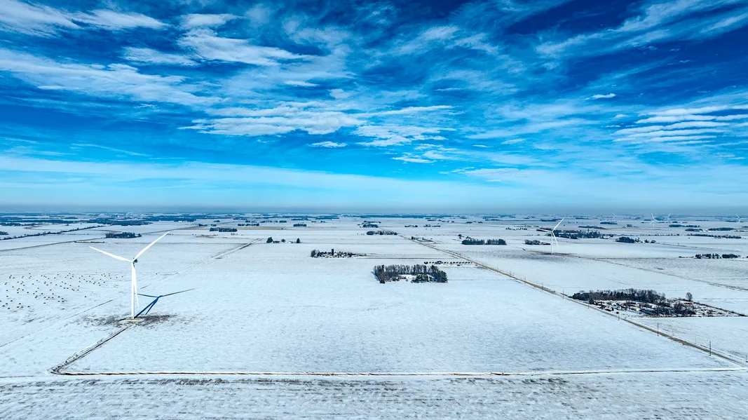
Pattern Tiled, 96.2 CSR2!!! With turbine Income!!!
Mitchell County 151 Acres m/l
Land Location: West side of Glass Road Section 1 St. Ansgar Township
Tract 151 Acres +/- owned by Nathaniel Skuster. 96.2 CSR2 per agridata.
Farm was pattern tiled in 2018, maps are available. Farm is open for 2026
crop year and Dry fertilizer has been applied, receipts available.
The North One-half (N ½) of Southeast Quarter (SE ¼); and South One-half (S ½) of Northeast
Quarter (NE ¼), Section One (1) Township Ninety-nine (99) North, Range Eighteen (18) West of
the 5th P.M., Mitchell County, Iowa,
EXCEPT a tract described as follows: Beginning at a point in the North Line of said South Onehalf
(S ½) of the Northeast Quarter (NE ¼) 16½ feet East from the Northwest Corner thereof,
thence West along the North Line of said South One-half (S ½) of the Northeast Quarter (NE ¼)
16½ feet to the Northwest Corner, thence at Right Angles South along the West Line of said
South One-half (S ½) of the Northeast Quarter (NE ¼), 16½ feet, thence Northeasterly in a
Direct Line to the Place of Beginning of Section One (1) Township Ninety-nine (99) North,
Range Eighteen (18) West of the 5th P.M., Mitchell County, Iowa
AND EXCEPT
That part of the South One-half (S ½) of the Northeast Quarter (NE ¼) of Section One (1),
Township Ninety-nine (99) North, Range Eighteen (18) West of the 5th P.M., Mitchell County,
Iowa as described in Plat of Survey filed May 9, 1994 in Book 4 of Plats Page 275.
Gross Acres 152+/-
Taxable Acres 151.70
Tillable Acres 151.75 per County Assessor
FSA Cropland Acres 149.59
Average CSR2 96.2 CSR2 per Agridata
Est. Taxes $3,078 yearly
Windmill Lease is paying approximately $18,931yr. Payments made
quarterly. Lease will transfer to new owner. Payment will be prorated
at closing. See lease for details.
Property Taxes: Property taxes will be prorated to the date of closing.
No survey will be provided.
From elevation to risk assessment
Search for detailed parcel information including; Elevation & Vegetation Maps, Ownership Information, Detailed Parcel Information, Crop History Map, Soil Survey Productivity Data, and more.
Research Parcel InformationDirections
Environmental Factors
Resources
Land for Sale by Jake Huff
Mitchell County Properties By Type
- Farms for Sale in Mitchell County, Iowa
- Undeveloped Land for Sale in Mitchell County, Iowa
- Recreational Property for Sale in Mitchell County, Iowa
- Residential Property for Sale in Mitchell County, Iowa
- Ranches for Sale in Mitchell County, Iowa
- Commercial Property for Sale in Mitchell County, Iowa
- Lakefront Property for Sale in Mitchell County, Iowa
- Beachfront Property for Sale in Mitchell County, Iowa
- Riverfront Property for Sale in Mitchell County, Iowa
- Hunting Land for Sale in Mitchell County, Iowa
- Horse Property for Sale in Mitchell County, Iowa
- Timberland for Sale in Mitchell County, Iowa
Properties for Sale Nearby Counties
Mitchell County Properties By City
- Carpenter, Iowa Land for Sale
- Little Cedar, Iowa Land for Sale
- Orchard, Iowa Land for Sale
- Osage, Iowa Land for Sale
- Saint Ansgar, Iowa Land for Sale
- Stacyville, Iowa Land for Sale
- Toeterville, Iowa Land for Sale
- Meyer, Iowa Land for Sale
- Mitchell, Iowa Land for Sale
- New Haven, Iowa Land for Sale
- Otranto, Iowa Land for Sale
- Rock Creek, Iowa Land for Sale
- More
