153 acres in Carbon County, Montana
Description
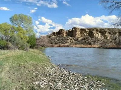
This ranch has been in the same family for just about 100 years! The original buildings where the family raised their children and the children raised their children are still on the property. The corrals are still functional and in use. The 200 inch of water rights date back to 1893 and 1897 and come directly from the Clark's Fork (of the Yellowstone) River. Even though the land follows the river for a mile, it is NOT in a flood plane. The mostly level tract includes four 20 acres parcels with a 73 acres remainder. The irrigation is via ditch and gated pipe. The homestead has been used for ranching only and is still fully fenced.
On the other side of the river are the hills of BLM land (Bureau of Land Management), so privacy is assured. There are nice homes in the area, good access via county road and private easement.
Electric is on the property, there is cell phone service and stunning mountain views. There are trees along the river and willows along the west side of the properties.
Presently inhabited by geese, ducks, grouse, deer, antelope and cattle. The fish are calling from the river!
Game Fish Opportunities:
Brown Trout, Burbot, Mountain Whitefish, Rainbow Trout
All Species Present:
Arctic Grayling, Brook Trout, Brown Trout, Channel Catfish, Common Carp, Emerald Shiner, Flathead Chub, Goldeye, Lake Chub, Longnose Dace, Longnose Sucker, Minnow, Mottled Sculpin, Mountain Sucker, Mountain Whitefish, Rainbow Trout, River Carpsucker, Shorthead Redhorse, Stonecat, Western Silvery/Plains Minnow, White Sucker, Yellowstone Cutthroat Trout, Burbot
Report from the Dept of Fish and Wildlife on the Clark's Fork
The river runs at a pretty good clip through Belfry and gets sluggish farther north around Bridger, where it also gets muddy. The fishing around Belfry is pretty good from what I saw. Maybe you should come out and try-fish :-) Here is an elevation map, the river drops 3,000 feet over 35 miles to Belfry:
From elevation to risk assessment
Search for detailed parcel information including; Elevation & Vegetation Maps, Ownership Information, Detailed Parcel Information, Crop History Map, Soil Survey Productivity Data, and more.
Research Parcel InformationEnvironmental Factors
Resources
Carbon County Properties By Type
- Ranches for Sale in Carbon County, Montana
- Residential Property for Sale in Carbon County, Montana
- Undeveloped Land for Sale in Carbon County, Montana
- Farms for Sale in Carbon County, Montana
- Riverfront Property for Sale in Carbon County, Montana
- Lakefront Property for Sale in Carbon County, Montana
- Horse Property for Sale in Carbon County, Montana
- Recreational Property for Sale in Carbon County, Montana
- Hunting Land for Sale in Carbon County, Montana
- Timberland for Sale in Carbon County, Montana
- Commercial Property for Sale in Carbon County, Montana
- Beachfront Property for Sale in Carbon County, Montana
Properties for Sale Nearby Counties
Carbon County Properties By City
- Bearcreek, Montana Land for Sale
- Belfry, Montana Land for Sale
- Boyd, Montana Land for Sale
- Bridger, Montana Land for Sale
- Edgar, Montana Land for Sale
- Fromberg, Montana Land for Sale
- Joliet, Montana Land for Sale
- Red Lodge, Montana Land for Sale
- Roberts, Montana Land for Sale
- Roscoe, Montana Land for Sale
- Alpine, Montana Land for Sale
- Fox, Montana Land for Sale
- More
- Luther, Montana Land for Sale
- Silesia, Montana Land for Sale
- Washoe, Montana Land for Sale
- Alex Boggio Place, Montana Land for Sale
- Bowler, Montana Land for Sale
- Chance, Montana Land for Sale
- George Place, Montana Land for Sale
- Hillsboro, Montana Land for Sale
- Montaqua, Montana Land for Sale
- Peterson Place, Montana Land for Sale
- Rankin Place, Montana Land for Sale
- Richel Lodge, Montana Land for Sale
- Rockvale, Montana Land for Sale
- Selmes, Montana Land for Sale
- Simpkins Place, Montana Land for Sale
- Wade, Montana Land for Sale
- Warren, Montana Land for Sale