3801 E. Palm Valley Blvd., Round Rock, TX 78664 - Williamson County
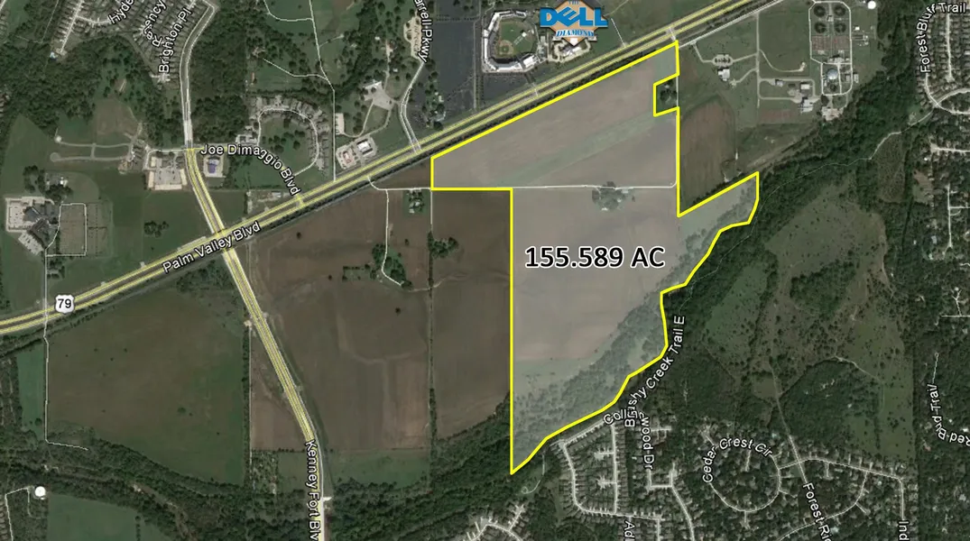
155.59 acres in Williamson County, Texas
The property is located south of Dell Diamond with 2,865 feet of
rail frontage just south of US HWY 79.
155.589 acres; There are very few large tracts remaining in the
City of Round Rock, that have access to utilities and are able to
be zoned for business uses.
Utilities: There is a 40 wide sanitary sewer easement along the
creek bank in the flood plain in the southern portion of the
property. There is also a 16 water line to the east of the
property and available for connection.
Zoning: The property has been annexed to the City of Round
Rock, but not yet zoned due to the location and merits of the
potential uses of the property.
From elevation to risk assessment
Search for detailed parcel information including; Elevation & Vegetation Maps, Ownership Information, Detailed Parcel Information, Crop History Map, Soil Survey Productivity Data, and more.
Research Parcel InformationResources
Land for Sale by Don Quick & Associates, Inc.
Williamson County Properties By Type
- Farms for Sale in Williamson County, Texas
- Ranches for Sale in Williamson County, Texas
- Residential Property for Sale in Williamson County, Texas
- Undeveloped Land for Sale in Williamson County, Texas
- Riverfront Property for Sale in Williamson County, Texas
- Hunting Land for Sale in Williamson County, Texas
- Commercial Property for Sale in Williamson County, Texas
- Recreational Property for Sale in Williamson County, Texas
- Lakefront Property for Sale in Williamson County, Texas
- Horse Property for Sale in Williamson County, Texas
- Timberland for Sale in Williamson County, Texas
- Beachfront Property for Sale in Williamson County, Texas
Properties for Sale Nearby Counties
Williamson County Properties By City
- Cedar Park, Texas Land for Sale
- Coupland, Texas Land for Sale
- Florence, Texas Land for Sale
- Georgetown, Texas Land for Sale
- Granger, Texas Land for Sale
- Hutto, Texas Land for Sale
- Jarrell, Texas Land for Sale
- Leander, Texas Land for Sale
- Liberty Hill, Texas Land for Sale
- Round Rock, Texas Land for Sale
- Schwertner, Texas Land for Sale
- Taylor, Texas Land for Sale
- More
- Thrall, Texas Land for Sale
- Walburg, Texas Land for Sale
- Weir, Texas Land for Sale
- Andice, Texas Land for Sale
- Beyersville, Texas Land for Sale
- Brushy Creek, Texas Land for Sale
- Frame Switch, Texas Land for Sale
- Friendship, Texas Land for Sale
- Hare, Texas Land for Sale
- Hoxie, Texas Land for Sale
- Jollyville, Texas Land for Sale
- Jonah, Texas Land for Sale
- Laneport, Texas Land for Sale
- New Corn Hill, Texas Land for Sale
- Noack, Texas Land for Sale
- Normans Crossing, Texas Land for Sale
- Rices Crossing, Texas Land for Sale
- Sandoval, Texas Land for Sale
- Sun City, Texas Land for Sale
- Theon, Texas Land for Sale
- Type, Texas Land for Sale
- Volente, Texas Land for Sale
- Waterloo, Texas Land for Sale
- Anderson Mill, Texas Land for Sale
- Berrys Creek, Texas Land for Sale
- Corn Hill, Texas Land for Sale
- Greens Crossing, Texas Land for Sale
- Hunt Crossing, Texas Land for Sale
- Jinks Branch, Texas Land for Sale
- Keelersville, Texas Land for Sale
- Mozo, Texas Land for Sale
- Norman, Texas Land for Sale
- North Georgetown, Texas Land for Sale
- Pond Springs, Texas Land for Sale
- Russell Crossing, Texas Land for Sale
- Seward Junction, Texas Land for Sale
- Turkey Hollow, Texas Land for Sale
- Walkerton, Texas Land for Sale
- White Stone, Texas Land for Sale
- Wuthrich Hill, Texas Land for Sale