74394 300th St, Clarks Grove, MN 56016 - Freeborn County
Auction Information

#1627 Groeneweg Estate
Description
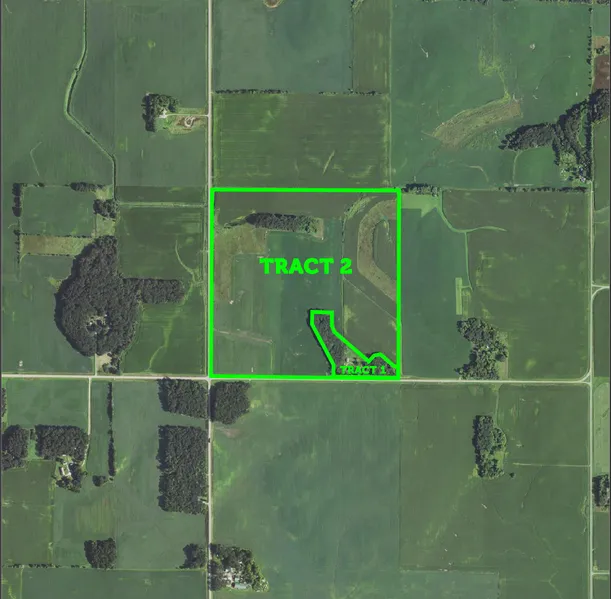
This 160 acre tract will be sold in two tracts, the building site with the surrounding woods and the remaining 147 acres of cropland. The house is three bedrooms and two bath with a walk out basement built in 1974, there are also outbuildings including a 30 x 48 Morton machine shed built in 2007. The farmland has a great CPI Soil rating of 86.8, great drainage with tile and the bordering drainage ditches and CRP acres for extra income.
PROPERTY FEATURES
Total Deeded Acres: 160
PID # (s): 180200050
Legal Description: SW of Section 20 Bath Twp, Freeborn Co. MN
Latitude/Longitude: 43 47 31.76 -93 23 3.74
Real Estate Taxes: $ 5,166 Special Assessments $321.14
CPI Soil Rating: 86.8
Total Cropland Acres: 134.83 Acres
Wheat Base Acres: 10 PLC Yield: 39
Corn Base Acres: 46.3 PLC Yield: 147
Soybean Base Acres: 63.3 PLC Yield: 34
CPI Soil Rating: 86.8
Classifications: HEL
CRP Acres: 15.2
CRP Annual Payment: $1,722
CRP Expires: 2019
Topography: rolling
Farm is currently rented for the 2018 growing season.
AUCTION TERMS:
$7,500 (nonrefundable) down for tract 1 the day of the sale and $50,000 (nonrefundable) down for tract 2 the day of the sale. Balance due on tract 1 June 1. Balance due on tract 2 either June 1, to receive cropland rent and pay 2018 taxes or November 1, 2018 and sellers will receive cropland rent and pay 2018 taxes. 2% Buyers fee will apply. Any Statement made the day of the auction takes precedence over previous material. All information provided herein was obtained from sources deemed reliable, but neither the auction company nor seller guarantee its accuracy.
From elevation to risk assessment
Search for detailed parcel information including; Elevation & Vegetation Maps, Ownership Information, Detailed Parcel Information, Crop History Map, Soil Survey Productivity Data, and more.
Research Parcel InformationDirections
From Albert Lea, take County Rd 20 North out of town for about 8 miles to 300th St, turn east for about a half mile, farm is on the left.
Environmental Factors
Resources
Freeborn County Properties By Type
- Lakefront Property for Sale in Freeborn County, Minnesota
- Farms for Sale in Freeborn County, Minnesota
- Undeveloped Land for Sale in Freeborn County, Minnesota
- Commercial Property for Sale in Freeborn County, Minnesota
- Hunting Land for Sale in Freeborn County, Minnesota
- Residential Property for Sale in Freeborn County, Minnesota
- Recreational Property for Sale in Freeborn County, Minnesota
- Timberland for Sale in Freeborn County, Minnesota
- Ranches for Sale in Freeborn County, Minnesota
- Horse Property for Sale in Freeborn County, Minnesota
- Beachfront Property for Sale in Freeborn County, Minnesota
- Riverfront Property for Sale in Freeborn County, Minnesota
Properties for Sale Nearby Counties
Freeborn County Properties By City
- Albert Lea, Minnesota Land for Sale
- Alden, Minnesota Land for Sale
- Clarks Grove, Minnesota Land for Sale
- Conger, Minnesota Land for Sale
- Emmons, Minnesota Land for Sale
- Freeborn, Minnesota Land for Sale
- Geneva, Minnesota Land for Sale
- Glenville, Minnesota Land for Sale
- Hartland, Minnesota Land for Sale
- Hayward, Minnesota Land for Sale
- Hollandale, Minnesota Land for Sale
- Twin Lakes, Minnesota Land for Sale
- More
- London, Minnesota Land for Sale
- Manchester, Minnesota Land for Sale
- Myrtle, Minnesota Land for Sale
- Oakland, Minnesota Land for Sale
- Bancroft, Minnesota Land for Sale
- Bath, Minnesota Land for Sale
- Gordonsville, Minnesota Land for Sale
- Hollandale Junction, Minnesota Land for Sale
- Lerdal, Minnesota Land for Sale
- Mansfield, Minnesota Land for Sale
- Moscow, Minnesota Land for Sale
- Muckland, Minnesota Land for Sale
- Murtaugh, Minnesota Land for Sale
- Petran, Minnesota Land for Sale
- Sigsbee, Minnesota Land for Sale
- South Hollandale, Minnesota Land for Sale
- Twin Grove, Minnesota Land for Sale