Auction Information

160 acres in Garfield County, Oklahoma
Absolute Auction
160 Acres Cropland/ Excellent Hunting ~ Selling with Minerals
No Minimums No Reserves
Monday Dec 3rd 10 AM
AUCTION LOCATION: off-site- Johnston Grain Elevator, 222 E. Maple Billings, OK. 74630
Directions to property: 2 miles west of Billings OK. on Hwy 15 and 2 miles south.
Lat. 36.30.5N Long. 97.28.46W Alt. 971
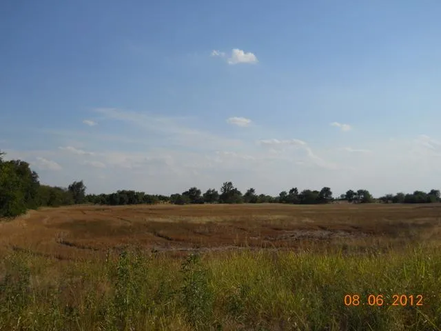
This farm consists of approximately 160 acres more or less. the farm is comprised of 91.5 acres of cropland. The balance is excellent hunting ground with trees, grassland and a small creek running through the north end of the property.
Farm service agency Info. It has approximately 160 acres of farm land 91.5 acres of DCP cropland acres with a 36 Bu. per. acre yield.
Principal Soil types are Kirkland-Renfrow class IIIe, Port Clay loam Class IIw & Kirkland Silt Loam class IIs
For more information call Jayton Tautfest at 580-716-4855 or Lippard Auctioneers Inc. 580-237-7174
LEGAL DESCRIPTION: NW/4 1-23N-3W Garfield County OK
TAXES: 2011 taxes were $470, 2012 taxes will be prorated to the day of closing.
VIEWING THE LAND: will be available daylight hours only!
POSSESSION: After the 2013 crop is harvested for the wheat land and at closing on the hunting land.
INCOME: The new buyer will get 1/3 of the wheat income.
MINERALS: will be offered separate from surface, and in combination with surface to determine which way brings the most money. Seller owns 160.64993 net mineral interest. Currently leased 5/10/11 for a 3 year, 3/16, with 2 year option.
INTERNET BIDDING: available by logging on to LippardAuctions Neither Auction Company or Seller is responsible in the event of loss signal by either side.
TERMS/CONDITIONS: 10% of the total purchase price is to be placed in escrow the day of the auction with the balance being due upon delivery of marketable title. All information is taken from sources believed reliable; however, no guarantee is being made by the Auction Company or the Seller. Buyers should satisfy themselves as to any inspections prior to bidding. Any announcements made the day of the auction supersede all advertising.
Sellers Evert Dale Wilmoth Family Trust
Susan Scarberry, Roslny Wilkin, Marilyn Pearce, and Harry R. Rector
From elevation to risk assessment
Search for detailed parcel information including; Elevation & Vegetation Maps, Ownership Information, Detailed Parcel Information, Crop History Map, Soil Survey Productivity Data, and more.
Research Parcel InformationDirections
Directions to property: 2 miles west of Billings OK. on Hwy 15 and 2 miles south.
Lat. 36.30.5N Long. 97.28.46W Alt. 971
Resources
Land for Sale by Lippard Real Estate & Auction
Garfield County Properties By Type
- Farms for Sale in Garfield County, Oklahoma
- Undeveloped Land for Sale in Garfield County, Oklahoma
- Ranches for Sale in Garfield County, Oklahoma
- Hunting Land for Sale in Garfield County, Oklahoma
- Commercial Property for Sale in Garfield County, Oklahoma
- Lakefront Property for Sale in Garfield County, Oklahoma
- Horse Property for Sale in Garfield County, Oklahoma
- Residential Property for Sale in Garfield County, Oklahoma
- Recreational Property for Sale in Garfield County, Oklahoma
- Timberland for Sale in Garfield County, Oklahoma
- Beachfront Property for Sale in Garfield County, Oklahoma
- Riverfront Property for Sale in Garfield County, Oklahoma
Properties for Sale Nearby Counties
Garfield County Properties By City
- Bison, Oklahoma Land for Sale
- Carrier, Oklahoma Land for Sale
- Covington, Oklahoma Land for Sale
- Douglas, Oklahoma Land for Sale
- Drummond, Oklahoma Land for Sale
- Enid, Oklahoma Land for Sale
- Fairmont, Oklahoma Land for Sale
- Garber, Oklahoma Land for Sale
- Hillsdale, Oklahoma Land for Sale
- Hunter, Oklahoma Land for Sale
- Kremlin, Oklahoma Land for Sale
- Lahoma, Oklahoma Land for Sale
- More
- Waukomis, Oklahoma Land for Sale
- Barr, Oklahoma Land for Sale
- Blanton, Oklahoma Land for Sale
- Breckinridge, Oklahoma Land for Sale
- Callahan, Oklahoma Land for Sale
- Cropper, Oklahoma Land for Sale
- Etna, Oklahoma Land for Sale
- Hayward, Oklahoma Land for Sale
- Imo, Oklahoma Land for Sale
- Ituna, Oklahoma Land for Sale
- Jonah, Oklahoma Land for Sale
- North Enid, Oklahoma Land for Sale
- Shea, Oklahoma Land for Sale