160 Acres w/ New Well Near Malheur Lake – Recreation, Ranch, Investment
Highlights
Description
Priced to sell, with average land values near Lake Malheur around $3,000 per acre. Seller financing available.
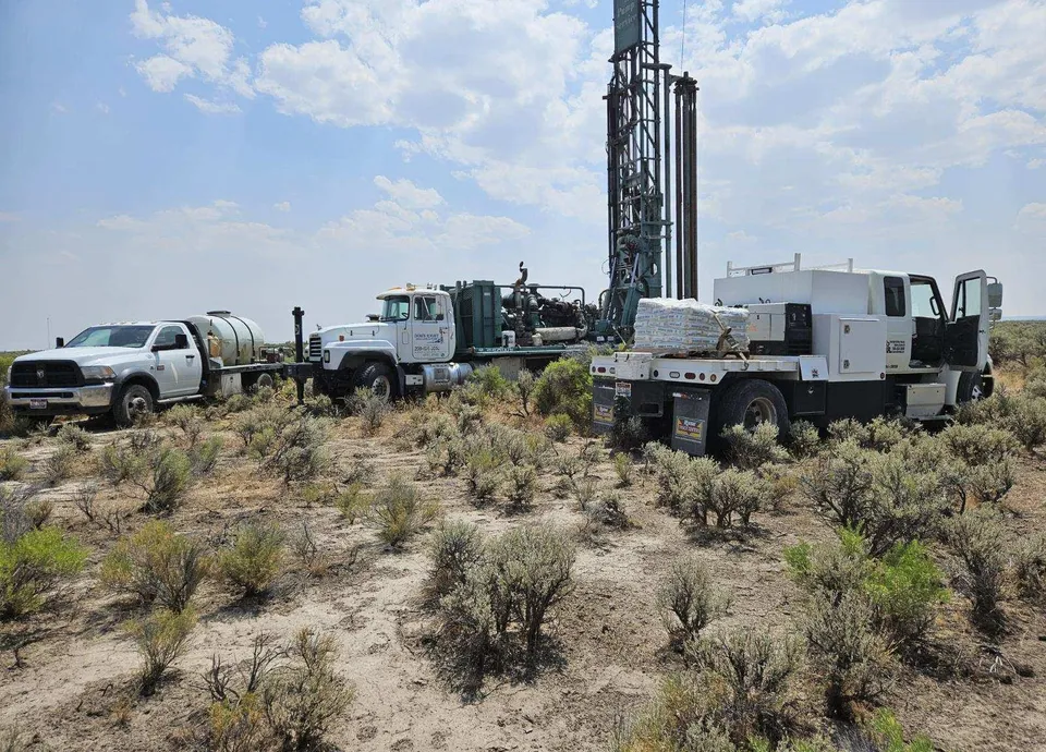
Water Security – A Major Advantage
A brand-new well installed in late 2024 provides documented water access, with water quality testing on file. In a region where water availability often determines land value, this is a significant upgrade compared to most undeveloped acreage offerings.
Ideal for Multiple Uses
This versatile property is well suited for:
-
Recreational use, including camping, hunting, or an off-grid retreat
-
Grazing or agricultural use
-
Long-term land holding or inflation hedge
-
Rural homestead or seasonal basecamp
The flat to gently rolling terrain allows for multiple build or use sites, while the surrounding open land preserves privacy, views, and long-term flexibility.
Access & Utilities
-
Historic road access off Rhu-Red S Road (buyer to verify legal access)
-
Electric utility quote available for future development planning
-
Quiet, low-density area with minimal neighboring development
Owner Financing Available
Owner financing may be available with a substantial down payment, offering flexibility for buyers seeking an alternative to traditional bank financing.
Location Highlights
-
Near Malheur Lake and the Malheur National Wildlife Refuge
-
Located in Harney County, Oregon, one of the largest and least developed counties in the western United States
-
Known for wide-open landscapes, dark skies, abundant wildlife, and exceptional privacy
Documents on File
-
Well report
-
Water quality test
-
Electric utility quote
Serious inquiries welcome. Properties of this size with newly installed wells are increasingly rare in Eastern Oregon.
Wildlife, Hunting & Outdoor Recreation
Harney County is well known for its abundant wildlife and expansive public and private lands. The area supports deer, pronghorn antelope, upland birds, waterfowl, and small game, making this property ideal for recreational use, a seasonal hunting basecamp, or an outdoor retreat. Proximity to Malheur Lake and surrounding wildlife areas enhances habitat diversity and migratory bird activity, while low population density and dark skies provide exceptional privacy and off-grid recreation potential.
From elevation to risk assessment
Search for detailed parcel information including; Elevation & Vegetation Maps, Ownership Information, Detailed Parcel Information, Crop History Map, Soil Survey Productivity Data, and more.
Research Parcel InformationDirections
Land for Sale by Matthew Fouts
Previously Sold by Matthew Fouts
Harney County Properties By Type
- Ranches for Sale in Harney County, Oregon
- Undeveloped Land for Sale in Harney County, Oregon
- Farms for Sale in Harney County, Oregon
- Residential Property for Sale in Harney County, Oregon
- Hunting Land for Sale in Harney County, Oregon
- Lakefront Property for Sale in Harney County, Oregon
- Riverfront Property for Sale in Harney County, Oregon
- Commercial Property for Sale in Harney County, Oregon
- Recreational Property for Sale in Harney County, Oregon
- Timberland for Sale in Harney County, Oregon
- Horse Property for Sale in Harney County, Oregon
- Beachfront Property for Sale in Harney County, Oregon
Properties for Sale Nearby Counties
Harney County Properties By City
- Burns, Oregon Land for Sale
- Crane, Oregon Land for Sale
- Diamond, Oregon Land for Sale
- Drewsey, Oregon Land for Sale
- Fields, Oregon Land for Sale
- Frenchglen, Oregon Land for Sale
- Hines, Oregon Land for Sale
- Princeton, Oregon Land for Sale
- Riley, Oregon Land for Sale
- Lawen, Oregon Land for Sale
- Andrews, Oregon Land for Sale
- Buchanan, Oregon Land for Sale
- More
- Dunnean, Oregon Land for Sale
- Frost Mill, Oregon Land for Sale
- Harney, Oregon Land for Sale
- Indian Village, Oregon Land for Sale
- Narrows, Oregon Land for Sale
- New Princeton, Oregon Land for Sale
- Suntex, Oregon Land for Sale
- Trout Creek, Oregon Land for Sale
- Van, Oregon Land for Sale
- Venator, Oregon Land for Sale
- Voltage, Oregon Land for Sale
- Wagontire, Oregon Land for Sale