Unit 16 Big Deer and Big Tract Neighbors
Situated in a neighborhood with proven whitetail genetics and large tracts. This 160 +/- acres is the perfect investment that will produce returns in mature bucks. Sandwiched between the famed Chain Ranch, almost 7,000 contiguous acres, and Sandy Creek, just a half mile east. There are six full-section parcels along this Creek Corridor to the east that are known for generating world-class deer. This manageable-sized 160 +/- acres is right between these two environmental forces, bringing a constant influx of quality deer.
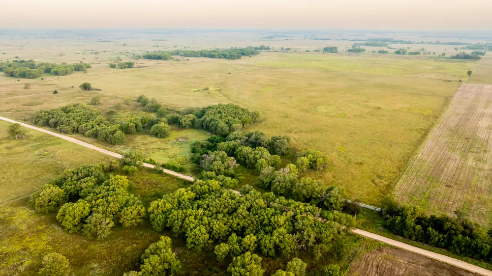
The property is characterized by head-high big bluestem grasses and brushy timber. The perfect balance of bedding and escape cover. This farm has multiple archery set-up locations in a mature timber woodlot on the south side of the farm. Vantage points across the expired CRP field make for long-distance opportunities. There is a small watering pond in the old pasture that keeps deer close. 126.82 +/- acres of tillable land have been in CRP native grass for many years. This CRP contract expired in 2021, and the grass has been hayed a few times since. These acres could be re-enrolled for predictable income, broken out for crop production, or fenced and grazed. The tillable acres are primarily loamy fine sand with a 50 NCCPI productivity rating. The balance of the property is approximately 33 +/- acres of enclosed pasture and mature trees. Rolling hills, tall trees adequate for ladder stands, and dense plum thickets.
Opportunities to purchase land in this size range, with big neighbors and noteworthy deer maturity, are rare. Contact the Listing Agent Sean Thomas at (620) 712-2775 to schedule a tour or see disclosures.
Property Features
-Unit 16 trophy whitetail
-Quality deer neighborhood
-Adjoining quarter section for sale
-Well-maintained roads, electricity at the road
-Tall expired CRP grass
-S06, T35, R08, ACRES 159.6 SW4
-15 +/- acres of mature timber
-Upland bird hunting, waterfowl potential
-15 miles Salt Plains National Wildlife Refuge
-Available for immediate hunting in 2025
-20 miles to Anthony, food, fuel, and lodging
-Mineral rights transfer to the new owner
From elevation to risk assessment
Search for detailed parcel information including; Elevation & Vegetation Maps, Ownership Information, Detailed Parcel Information, Crop History Map, Soil Survey Productivity Data, and more.
Research Parcel InformationDirections
From Waldron, travel north on Southwest 80th Avenue for one mile, turn left, and go west on Southwest 90 Road. Continue on Southwest 90 Road for 2.5 miles. The property is on the north side of the road.
Resources
Land for Sale by Sean Thomas
Harper County Properties By Type
- Ranches for Sale in Harper County, Kansas
- Farms for Sale in Harper County, Kansas
- Lakefront Property for Sale in Harper County, Kansas
- Residential Property for Sale in Harper County, Kansas
- Hunting Land for Sale in Harper County, Kansas
- Recreational Property for Sale in Harper County, Kansas
- Undeveloped Land for Sale in Harper County, Kansas
- Commercial Property for Sale in Harper County, Kansas
- Horse Property for Sale in Harper County, Kansas
- Riverfront Property for Sale in Harper County, Kansas
- Timberland for Sale in Harper County, Kansas
- Beachfront Property for Sale in Harper County, Kansas
Properties for Sale Nearby Counties
Harper County Properties By City
- Anthony, Kansas Land for Sale
- Attica, Kansas Land for Sale
- Bluff City, Kansas Land for Sale
- Danville, Kansas Land for Sale
- Freeport, Kansas Land for Sale
- Harper, Kansas Land for Sale
- Waldron, Kansas Land for Sale
- Corwin, Kansas Land for Sale
- Duquoin, Kansas Land for Sale
- Crisfield, Kansas Land for Sale
- Crystal Springs, Kansas Land for Sale
- Hawk, Kansas Land for Sale
- More