Auction Information
160 acres in Jackson County, Oregon
Property 1202-7
160 Acre Round Angel Timber Tract
Published Reserve
$159,850
Last Asking
First Time Offered
Size
160 Acres
Elevation
3,900 Feet to 4,200 Feet
Zoning
FR (Forest Resource)
Property Inspection
At Any Time
Financing
Subject to Sellers approval of Purchasers credit: A 20% down payment with five annual payments and interest at the prime rate plus 2%. Balance to be paid prior to any timber harvest. See Supplemental Information Package for detail regarding financing terms and conditions.
Description
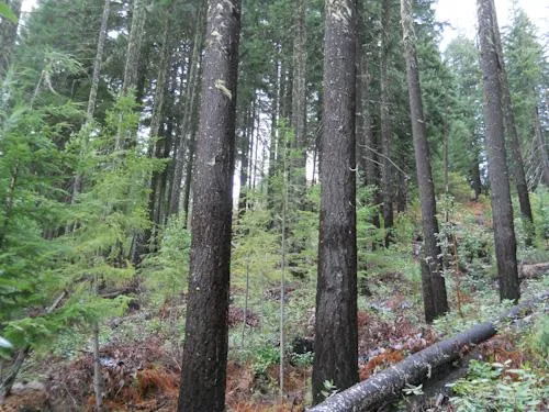
The 160 acre Round Angel timber tract is located in the northern section of Jackson County, 11 miles northwest of the Upper Rogue River community of Trail. Railroad Gap and BLM Road 33312.1 provide access to the tract. There are 88 acres of wellstocked 25 year old Douglasfir reproduction that should be harvestready in 15 to 20 years, and an estimated 624 MBF of 89 to 98 year old Douglasfir on 40 acres of the tract. The balance of the tract is lightlystocked pockets with a mix of species. There are existing logging spurs which could be reopened to facilitate logging.
The land west of the BLM road contains the bulk of the 25 year old reproduction and is bisected by the head water of Salt Creek. The eastern half of the tract has a ridgetop with moderate slopes, and the western section has gentle topography. The Douglasfir site index is primarily IV. Adjoining owners include the BLM to the north and east, and private timberland owners to the north, south and west.
Location
Township 33 South, Range 3 West, Section 12, Tax Lot 1200. From Medford, take OR Hwy 62(Crater Lake Highway) north to Highway 234 and take Highway 234 west. At 6.2 miles, turn right onto Meadows Road. At 8 miles turn right onto Evans Creek Road. At 4.5 miles, turn left onto East Fork Evans Creek Road. Follow this road 4.3 miles and then bear left at a fork onto BLM 33217. After 1.7 miles, turn right onto Railroad Gap Road. Travel 2.3 miles to the east boundary of the parcel, near the NE corner.
From elevation to risk assessment
Search for detailed parcel information including; Elevation & Vegetation Maps, Ownership Information, Detailed Parcel Information, Crop History Map, Soil Survey Productivity Data, and more.
Research Parcel InformationLand for Sale by Colleen Cowan
Jackson County Properties By Type
- Undeveloped Land for Sale in Jackson County, Oregon
- Farms for Sale in Jackson County, Oregon
- Riverfront Property for Sale in Jackson County, Oregon
- Residential Property for Sale in Jackson County, Oregon
- Lakefront Property for Sale in Jackson County, Oregon
- Ranches for Sale in Jackson County, Oregon
- Commercial Property for Sale in Jackson County, Oregon
- Horse Property for Sale in Jackson County, Oregon
- Timberland for Sale in Jackson County, Oregon
- Recreational Property for Sale in Jackson County, Oregon
- Hunting Land for Sale in Jackson County, Oregon
- Beachfront Property for Sale in Jackson County, Oregon
Properties for Sale Nearby Counties
Jackson County Properties By City
- Ashland, Oregon Land for Sale
- Butte Falls, Oregon Land for Sale
- Central Point, Oregon Land for Sale
- Eagle Point, Oregon Land for Sale
- Gold Hill, Oregon Land for Sale
- Jacksonville, Oregon Land for Sale
- Medford, Oregon Land for Sale
- Phoenix, Oregon Land for Sale
- Prospect, Oregon Land for Sale
- Rogue River, Oregon Land for Sale
- Shady Cove, Oregon Land for Sale
- Talent, Oregon Land for Sale
- More
- Trail, Oregon Land for Sale
- White City, Oregon Land for Sale
- Applegate, Oregon Land for Sale
- Rogue Elk, Oregon Land for Sale
- Beagle, Oregon Land for Sale
- Bitter Lick, Oregon Land for Sale
- Brownsboro, Oregon Land for Sale
- Buckhorn Springs, Oregon Land for Sale
- Buncom, Oregon Land for Sale
- Bybee Corner, Oregon Land for Sale
- Cascade Gorge, Oregon Land for Sale
- Climax, Oregon Land for Sale
- Colestin, Oregon Land for Sale
- Copper, Oregon Land for Sale
- Dardanelles, Oregon Land for Sale
- Foots Creek, Oregon Land for Sale
- Lake Creek, Oregon Land for Sale
- Lincoln, Oregon Land for Sale
- McKee Bridge, Oregon Land for Sale
- McLeod, Oregon Land for Sale
- Mountain View, Oregon Land for Sale
- Pinehurst, Oregon Land for Sale
- Ruch, Oregon Land for Sale
- Sams Valley, Oregon Land for Sale
- Seven Oaks, Oregon Land for Sale
- Starvation Heights, Oregon Land for Sale
- Table Rock, Oregon Land for Sale
- Tolo, Oregon Land for Sale
- Union Creek, Oregon Land for Sale
- Wimer, Oregon Land for Sale