Auction Information
1,632 acres in Del Norte County, California
PUBLISHED RESERVE PRICE: $4,000,000*
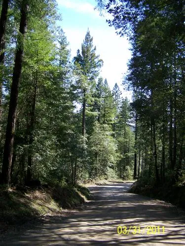
The 1,632 acre Smith River Timber Tract is located along Low Divide Ridge west of Smith River, north of Jedediah Smith Redwoods State Park and six miles northeast of Crescent City. There is year-round access to Highway 101. The majority of the lands are within the Six Rivers National Forest. The Del Norte Golf Course is located south of the property. The property consists of six non-contiguous parcels ranging from 18 to 518 acres. The Smith River tract has good access to Douglas- fir log markets north to Brookings, Oregon, redwood and Douglas-fir log markets south to Arcata and Eureka, California, and to export docks along Humboldt Bay.
Low Divide Road provides access to an estimated 1,000 acres of the Smith River tract, with the balance of the tract accessible from USFS roads through a Special Use Permit. There is a well-developed system of logging roads throughout most of the property. A new culvert is required to cross Mill Creek within Parcel A. An estimated 85% of the property will use ground-based logging systems for logging.
The Smith River tract has an estimated 23,349 MBF of primarily Douglas-fir and redwood, with a component of hemlock, pine, Port Orford cedar and western red cedar, based on an updated cruise report completed by James L. Able Forestry in January, 2011. There is also an estimated 7,000 MBF of hardwood, with 3,288 MBF red alder and the balance tan oak. (See Supplemental Information Package for cruise report).
The majority of the property has moderate southwest facing slopes with open grassy areas along Low Ridge. The estimated forest site classification is II to IV.
Almost two-thirds of all timber harvest volume at the Smith River tract was undertaken in 1998, which has allowed significant growth of the existing inventory. The last harvest of 685 MBF was in 2010. It is projected that in ten years the conifer volumes could exceed 35,600 MBF with a 62% increase in redwood volume and 48% increase in Douglas-fir volume.
Timber Harvest Plan #1-08-132 DEL covers approximately 1,163 acres, excluding timber Stands 2, 6 and 9, and does not expire until December 2013.
It is estimated that up to an additional 8,500 MBF could be harvested under the THP, based on current regulations.
The Smith River Timber Tract is being offered as part of this Sealed Bid Auction in either its entirety, or in four parcels (A, B, C and D) ranging from 18 to 611 acres, providing opportunity for acquisition of three medium-size tree farms with both Douglas-fir and redwood timber. The existing THP will be assigned to Parcels A, B, and D if parcels are acquired individually.
Parcel A - 485 Acres
Reserve Price $1,025,000*/$2,113 per acre
Parcel A is located west of Low Divide Road, with access from USFS Road to the northeast corner of Stand 4 in Section 9. Physical access to Stand 2 in Section 6 is from the Green Diamond Resource Company road system. Mill Creek and Savoy Creek bisect the parcel. A new culvert or bridge is required by the THP to cross Mill Creek.
There are an estimated 7,651 MBF within Parcel A, with Stands 3 and 4 covered under the existing THP.
Parcel B - 518 Acres
Reserve Price $1,385,000*/$2,673 per acre
Parcel B has access from and is primarily located west of Low Divide Road. It has an estimated 6,999 MBF. Sultan and Mill Creeks are located on the parcel. The existing THP covers the entire parcel.
Parcel C - 18 Acres
Reserve Price No Minimum Bid*
This 18 acre parcel is isolated and is located between Low Divide Road and Mule Creek, with no developed road access. There is an estimated 266 MBF of mostly Douglas-fir on the parcel. The existing THP does not cover this property.
Parcel D - 611 Acres
Reserve Price $1,590,000*/$2,602 per acre
This is the largest parcel being offered as part of the Smith River Timber Tract, and contains an estimated 8,423 MBF, with fifty percent of all redwood volume, or 2,299 MBF, for the entire Smith River Timber Tract contained on Parcel D.
There is access from Low Divide Road and secondary access from USFS Roads to Stands 8 and 9. Rock and Peacock Creeks bisect the southern portion of the property.
The existing THP does not cover the 120 acres in Stand 9.
**The sale of individual Auction Properties 100, 200, 300, 400, 500, 600, 700, 800 and 900 is subject to total accepted bids in the aggregate to equal, or exceed, $27,815,000.
From elevation to risk assessment
Search for detailed parcel information including; Elevation & Vegetation Maps, Ownership Information, Detailed Parcel Information, Crop History Map, Soil Survey Productivity Data, and more.
Research Parcel InformationDirections
LOCATION:
Township 17 North, Range 1 East
Parcel A Sections 6, 5, 9 and 16
Parcel B Sections 8, 17 and 16
Parcel C Section 16
Parcel D Sections 20, 21, 29 and 32
DIRECTIONS: From Crescent City, take Highway 101 North to State Route 197 and proceed east for 4.5 miles. Take a left on Low Divide Road. The property parcels are on both sides of Low Divide Road.
Land for Sale by Colleen Cowan
Del Norte County Properties By Type
- Undeveloped Land for Sale in Del Norte County, California
- Riverfront Property for Sale in Del Norte County, California
- Lakefront Property for Sale in Del Norte County, California
- Beachfront Property for Sale in Del Norte County, California
- Farms for Sale in Del Norte County, California
- Ranches for Sale in Del Norte County, California
- Recreational Property for Sale in Del Norte County, California
- Residential Property for Sale in Del Norte County, California
- Commercial Property for Sale in Del Norte County, California
- Timberland for Sale in Del Norte County, California
- Horse Property for Sale in Del Norte County, California
- Hunting Land for Sale in Del Norte County, California
Properties for Sale Nearby Counties
Del Norte County Properties By City
- Crescent City, California Land for Sale
- Fort Dick, California Land for Sale
- Gasquet, California Land for Sale
- Klamath, California Land for Sale
- Smith River, California Land for Sale
- Adams Station, California Land for Sale
- Camp Klamath, California Land for Sale
- Darlingtonia, California Land for Sale
- Douglas Park, California Land for Sale
- False Klamath, California Land for Sale
- French Hill, California Land for Sale
- Hiouchi, California Land for Sale
- More
- Hoppaw, California Land for Sale
- Klamath Glen, California Land for Sale
- Pacific Shores, California Land for Sale
- Patrick Creek, California Land for Sale
- Peak Eight, California Land for Sale
- Requa, California Land for Sale
- Rockland, California Land for Sale
- Scaath, California Land for Sale
- Tryon Corner, California Land for Sale
- Yontocket, California Land for Sale