Rawhide Gulch Ranch
Description
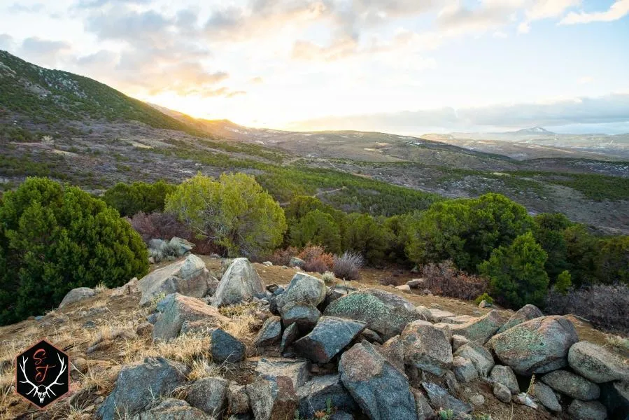
Rawhide Gulch Ranch is +/- 1,640 acres of diverse mountain ground located 15 minutes east of Montrose, CO. The land is incredibly diverse with elevation changes from 7,285 to 9,000 ft. Vegetation consists of pinyon pine, juniper, oak brush, cottonwoods, aspen trees and sage flats. The habitat lends itself to great hunting for elk, mule deer, bear and turkey alike (check out the game trail camera photos on the website)! The ranch directly borders +/- 600 acres of BLM to the south which extends additional recreational opportunities for hunting, hiking, shooting, camping etc. For the avid fisherman there are numerous areas nearby to wet a line! You'll be hard pressed to find a property of this size with all Rawhide Gulch Ranch has to offer at such a reasonable price!
Overview:
-1,640 acres ranch 15 minutes east of Montrose
-No conservation easements
-Hunting (elk, mule deer, bear and lion)
-Small game hunting (bobcat, coyote and turkey)
-New road system
-New pond
-Springs
-Irrigation canal provides additional water for wildlife
-New survey available
-Grazing for cattle or sheep
-Two deeded access easements
-1.5 hrs from skiing either Mt. Crested Butte or Telluride
Hunting:
Ranch is located in GMU 64
OTC (over the counter) for elk
Easy deer draw for landowners and the public
Easy to obtain bear licenses
Qualifies for the Landowner Preference Program for deer
Fishing:
Close proximity to Black Canyon of the Gunnison River (world famous fishery)
Blue Mesa Resv. 30 minutes away for Kokanee Salmon
Thousands of acres of public land river, stream and lake fishing
Land:
Elevation changes from 7,285 to 9,000
Amazing views of Montrose city lights
Vegetation consists of oak brush, P&J, aspens, cottonwoods
Borders 600 acres of BLM
Strong candidate for a conservation easement
Montrose:
Population roughly 20,000
Elevation 5,807 ft
Weather averages 39 degrees in January to 83 degrees in June (relatively mild)
Airport has daily jet service
Gate way to Moab for hiking and biking, Ouray hot springs and skiing in nearby resorts.
Give us a call today for additional information.
From elevation to risk assessment
Search for detailed parcel information including; Elevation & Vegetation Maps, Ownership Information, Detailed Parcel Information, Crop History Map, Soil Survey Productivity Data, and more.
Research Parcel InformationDirections
Located just N. of HWY 50 near Cerro Summit.
Environmental Factors
Resources
Montrose County Properties By Type
- Undeveloped Land for Sale in Montrose County, Colorado
- Farms for Sale in Montrose County, Colorado
- Ranches for Sale in Montrose County, Colorado
- Riverfront Property for Sale in Montrose County, Colorado
- Hunting Land for Sale in Montrose County, Colorado
- Residential Property for Sale in Montrose County, Colorado
- Lakefront Property for Sale in Montrose County, Colorado
- Horse Property for Sale in Montrose County, Colorado
- Recreational Property for Sale in Montrose County, Colorado
- Commercial Property for Sale in Montrose County, Colorado
- Timberland for Sale in Montrose County, Colorado
- Beachfront Property for Sale in Montrose County, Colorado
Properties for Sale Nearby Counties
Montrose County Properties By City
- Bedrock, Colorado Land for Sale
- Cimarron, Colorado Land for Sale
- Montrose, Colorado Land for Sale
- Naturita, Colorado Land for Sale
- Nucla, Colorado Land for Sale
- Olathe, Colorado Land for Sale
- Paradox, Colorado Land for Sale
- Redvale, Colorado Land for Sale
- Colona, Colorado Land for Sale
- Cedar Creek, Colorado Land for Sale
- East Vancorum, Colorado Land for Sale
- Frost, Colorado Land for Sale
- More
- Hoovers Corner, Colorado Land for Sale
- Lujane, Colorado Land for Sale
- Oak Grove, Colorado Land for Sale
- Pea Green Corner, Colorado Land for Sale
- Roe, Colorado Land for Sale
- Uncompahgre, Colorado Land for Sale
- Uravan, Colorado Land for Sale
- Ute, Colorado Land for Sale
- Vancorum, Colorado Land for Sale
- Vernal, Colorado Land for Sale
- West Vancorum, Colorado Land for Sale