4842 - Hwy 8
The Preston Drive (Listing #4835) and Highway 8 (Listing #4842) Tracts will be offered by lump sum sealed bid on Friday, August 13, 2021, at 10:00 a.m. Bids may submitted for either or both tracts.
The Preston Drive Tract (Listing #4835) is described as Part of SE of NW, Section 25, Township 10 South, Range 13 West, containing 29 acres, more or less, Dallas County, Arkansas (see attached maps). Access is frontage on gated Preston Drive. Site index for loblolly pine (base age 50) averages eighty-seven (87) feet on fine sandy and silt loam soils. Timber consists of 28 acres of 2001 pine plantation with 1 acre in pipeline right-of-way. Based on inventory of 28 acres of 2001 pine plantation conducted by Kingwood Forestry in May, 2021, estimated tree counts and timber volumes are as follows:
Pine Sawtimber: 506 Tons
Pine CNS: 691 Tons
Pine Pulpwood: 1,706 Tons
Pine Topwood: 234 Tons
--------------------------------------------
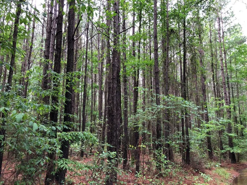
The Highway 8 Tract (Listing #4842) is described as Part of Section 36, Township 10 South, Range 13 West; Parts of Sections 31 and 32, Township 10 South, Range 12 West; all containing a total of 171 acres, more or less, Dallas County, Arkansas (see attached maps). Access is via gated woods road from Highway 8. Site index for loblolly pine averages eighty-seven (87) feet (base age 50) on fine sandy and silt loam soils. Timber consists of 39 acres of merchantable native pine / hardwood, 45 acres of merchantable 1994 pine plantation, 81 acres of pre-merchantable 2012 pine plantation, and 6 acres in Streamside Management Zone. Based on inventory of merchantable timber on 84 acres conducted by Kingwood Forestry in May, 2021, estimated tree counts and timber volumes are as follows:
Pine Sawtimber: 1,095 Tons
Pine CNS: 1,424 Tons
Pine Pulpwood: 5,204 tons
Pine Topwood: 495 Tons
Hardwood Pulpwood: 571 Tons
Due to variations in cruising methods, utilization standards, and scaling practices, tree counts and timber volume estimates cannot be guaranteed. Volume report in Tons and Board Feet with tree counts by species, diameter, and height are available on our website.
From elevation to risk assessment
Search for detailed parcel information including; Elevation & Vegetation Maps, Ownership Information, Detailed Parcel Information, Crop History Map, Soil Survey Productivity Data, and more.
Research Parcel InformationResources
Land for Sale by John McAlpine
Dallas County Properties By Type
- Undeveloped Land for Sale in Dallas County, Arkansas
- Hunting Land for Sale in Dallas County, Arkansas
- Timberland for Sale in Dallas County, Arkansas
- Farms for Sale in Dallas County, Arkansas
- Ranches for Sale in Dallas County, Arkansas
- Commercial Property for Sale in Dallas County, Arkansas
- Recreational Property for Sale in Dallas County, Arkansas
- Lakefront Property for Sale in Dallas County, Arkansas
- Residential Property for Sale in Dallas County, Arkansas
- Horse Property for Sale in Dallas County, Arkansas
- Beachfront Property for Sale in Dallas County, Arkansas
- Riverfront Property for Sale in Dallas County, Arkansas
Properties for Sale Nearby Counties
Dallas County Properties By City
- Carthage, Arkansas Land for Sale
- Fordyce, Arkansas Land for Sale
- Ivan, Arkansas Land for Sale
- Sparkman, Arkansas Land for Sale
- Manning, Arkansas Land for Sale
- Willow, Arkansas Land for Sale
- Bucksnort, Arkansas Land for Sale
- Bunn, Arkansas Land for Sale
- Cooney, Arkansas Land for Sale
- Eagletie, Arkansas Land for Sale
- Farindale, Arkansas Land for Sale
- Forrest Bonner, Arkansas Land for Sale
- More
- Ivy, Arkansas Land for Sale
- Jacinto, Arkansas Land for Sale
- North Fordyce, Arkansas Land for Sale
- Ouachita, Arkansas Land for Sale
- Pine Grove, Arkansas Land for Sale
- Princeton, Arkansas Land for Sale
- Ramsey, Arkansas Land for Sale
- Round Hill, Arkansas Land for Sale
- Tulip, Arkansas Land for Sale
- Wave, Arkansas Land for Sale