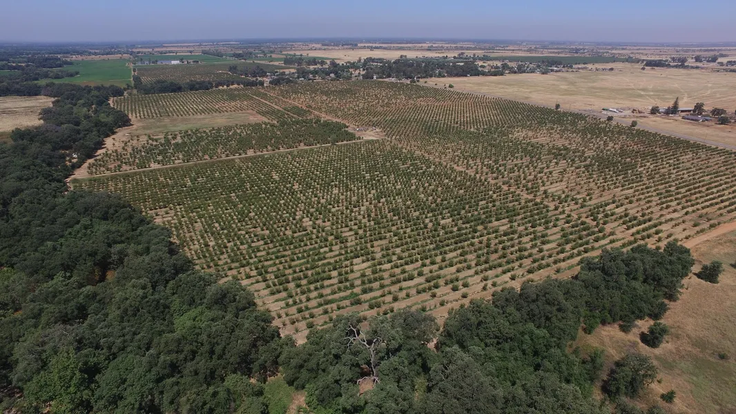
Yuba County Prune Orchard
Location: From Highway 70 take the Lower Honcut Road Exit. Go East for 3.1 miles, the property is on the right side of the road. Its shown by appointment only! DO NOT TRESPASS!
APN#: Butte County APN#: 028-030-032 & 028-030-045
Soils: The entire farm is comprised of primarily Class II-V Soils. Please review the attached soils map for more information.
Water: Water is provided through two deep water wells.
The well on the 115 acres does 940 GPM and has a new 75hp motor. It is irrigated with drip irrigation.
The well on the 63 acres does 740 GPM and has new bowls. It is irrigated with micro sprinklers.
Prune Orchard: The Orchard is broken up into two sections:
The East Section has approximately 100+/- planted acres on a 1717 Spacing
The West Section has approximately 59+/- planted acres on a 1717 Spacing
Leases: There are no leases on the subject property.
Oil, Gas, & Mineral Rights: Any oil, gas, and mineral rights owned by the seller are to transfer to the buyer at the close of escrow.
Taxes: The property is NOT enrolled in the Williamson Act. The property taxes will be a little over 1% of the purchase price at the close of escrow.
Price: $2,838,080
Terms: Cash at the close of escrow
Comments: Producing Honcut Prune Orchard! Orchard has been brought back to life by the current owner and has a bright future. This orchard is priced to sell! It is in a good ground water area. It recently has had some major well repairs recently completed. Its located along a paved county road. Its comprised of two legal parcels. It has walnuts, prunes, almonds, and rice in the general vicinity. Please call Charter Realty for more info!
From elevation to risk assessment
Search for detailed parcel information including; Elevation & Vegetation Maps, Ownership Information, Detailed Parcel Information, Crop History Map, Soil Survey Productivity Data, and more.
Research Parcel InformationDirections
Location: From Highway 70 take the Lower Honcut Road Exit. Go East for 3.1 miles, the property is on the right side of the road. Its shown by appointment only! DO NOT TRESPASS!
Resources
Land for Sale by Ward Charter
Butte County Properties By Type
- Undeveloped Land for Sale in Butte County, California
- Farms for Sale in Butte County, California
- Ranches for Sale in Butte County, California
- Residential Property for Sale in Butte County, California
- Hunting Land for Sale in Butte County, California
- Horse Property for Sale in Butte County, California
- Commercial Property for Sale in Butte County, California
- Riverfront Property for Sale in Butte County, California
- Recreational Property for Sale in Butte County, California
- Lakefront Property for Sale in Butte County, California
- Timberland for Sale in Butte County, California
- Beachfront Property for Sale in Butte County, California
Properties for Sale Nearby Counties
Butte County Properties By City
- Bangor, California Land for Sale
- Berry Creek, California Land for Sale
- Biggs, California Land for Sale
- Chico, California Land for Sale
- Clipper Mills, California Land for Sale
- Durham, California Land for Sale
- Feather Falls, California Land for Sale
- Forbestown, California Land for Sale
- Forest Ranch, California Land for Sale
- Gridley, California Land for Sale
- Magalia, California Land for Sale
- Nelson, California Land for Sale
- More
- Oroville, California Land for Sale
- Palermo, California Land for Sale
- Paradise, California Land for Sale
- Richvale, California Land for Sale
- Stirling City, California Land for Sale
- Brush Creek, California Land for Sale
- Butte Meadows, California Land for Sale
- Butte Valley, California Land for Sale
- Chapmantown, California Land for Sale
- Cohasset, California Land for Sale
- Dayton, California Land for Sale
- East Gridley, California Land for Sale
- Honcut, California Land for Sale
- Hurleton, California Land for Sale
- La Porte, California Land for Sale
- Nimshew, California Land for Sale
- Nord, California Land for Sale
- Oregon City, California Land for Sale
- Paradise Pines, California Land for Sale
- Pentz, California Land for Sale
- Pulga, California Land for Sale
- Richardson Springs, California Land for Sale
- Robinsons Corner, California Land for Sale
- South Oroville, California Land for Sale
- Thermalito, California Land for Sale
- Wyandotte, California Land for Sale
- Yankee Hill, California Land for Sale
- Anita, California Land for Sale
- Barber, California Land for Sale
- Blavo, California Land for Sale
- Camp Eighteen, California Land for Sale
- Cana, California Land for Sale
- Concow, California Land for Sale
- Craig, California Land for Sale
- Cresta, California Land for Sale
- De Sabla, California Land for Sale
- DeSabla, California Land for Sale
- Dodge Place, California Land for Sale
- Dodgeland, California Land for Sale
- East Biggs, California Land for Sale
- Elsey, California Land for Sale
- Esquon, California Land for Sale
- Fagan, California Land for Sale
- Glenburn, California Land for Sale
- Helltown, California Land for Sale
- Hughes Place, California Land for Sale
- Inskip, California Land for Sale
- Irish Town, California Land for Sale
- James, California Land for Sale
- Jonesville, California Land for Sale
- Junction House, California Land for Sale
- Kister, California Land for Sale
- Kramm, California Land for Sale
- Lovelock, California Land for Sale
- Lumpkin, California Land for Sale
- Mayaro, California Land for Sale
- Merrimac, California Land for Sale
- Mineral Slide, California Land for Sale
- Nelsons Crossing, California Land for Sale
- Old Forbestown, California Land for Sale
- Oroleve, California Land for Sale
- Oroville Junction, California Land for Sale
- Parkhill, California Land for Sale
- Peachton, California Land for Sale
- Poe, California Land for Sale
- Powellton, California Land for Sale
- Ramada, California Land for Sale
- Rancho Llano Seco, California Land for Sale
- Riceton, California Land for Sale
- Robinson Mills, California Land for Sale
- Roble, California Land for Sale
- Rogerville, California Land for Sale
- Shippee, California Land for Sale
- Stirling Junction, California Land for Sale
- Toadtown, California Land for Sale
- Vista Robles, California Land for Sale
- Wicks Corner, California Land for Sale