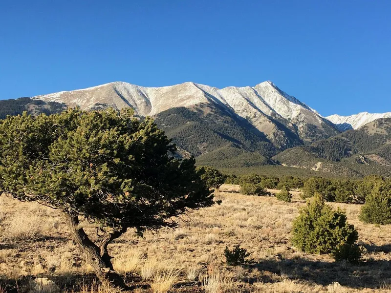
RARE! STUNNING Views w/ trees- 6.4 acres! - Blanca, CO
Description
Please visit our website at thelandbox(.)com for video, more pics & the most current status.
Beautiful and Private 6.41 AC s nestled in the foothills. Peaceful mountain land, nestled in foothills of Breathtaking Mt. Blanca. 35 mins to Alamosa and the new Drive thru Starbucks :).....Unreal..
Close to Outdoor fun: hiking, fishing, Great Sand Dunes. If you have down payment of $1,000 we will owner finance. Pre Approved. Spend your time on this rare Gem in Southern Colorado. NO Covenants or HOA Fees.
$1,000 Down/$239 PER Month-Finance Terms-Instant Approval/No Credit Checks- Interest Rate 0%
Loan Term: 75 months
Monthly Payment $239 a month (plus a $20 note servicing fee and yearly taxes)
Document Fee: $250
Or
Pay In Full Cash Discount-$15,500
Document Fee: $250 (non-refundable)
Miles To:
- 23.2 miles to Alamosa (Walmart, Hospital, Starbucks, College)
- 24.4 miles to Great Sand Dunes Np
- 74.4 miles to Red River Ski
- 88.6 miles to Taos
- 163 miles to Santa Fe
- 107 miles to Pueblo
- 149 miles to Colorado springs
- 220 miles to Denver
Land Details:
- Address: TBD 17th St, Alamosa, CO 81101
- Int 18-014
- Legal Address: Lot 9 Block 8 Unit 16 SAN Luis Valley Ranches, Costilla County, Colorado
- Road Access: County Dirt Road
- Terrain: Flat
- Sub Type: Vacant Land
- Property Type: Vacant/Rural Residential/Recreation
- City: Alamosa
- State: Co
- Zip Code: 81101
- County/Area: Costilla County
- Size: 6.41 acres
- Yearly Taxes: $100 Approx.
- Hoa: None
- Deed Type: Warranty Deed
Utilities:
- Power - none/Solar/Generator
- Water - Would need to install well/ haul water/Cistern
- Septic - Would need to install septic
- Zoning Definition: Build or Camping allowed a limited part of the year. Please contact the county to confirm use or restrictions.
From elevation to risk assessment
Search for detailed parcel information including; Elevation & Vegetation Maps, Ownership Information, Detailed Parcel Information, Crop History Map, Soil Survey Productivity Data, and more.
Research Parcel InformationDirections
Wanna Visit?
Best Route to visit the property-
From Blanca & Highway 160:
Go North on Storm Avenue to 17th Street
Quick Right on 17th Street to a quick left on Oak Avenue.
Continue North on Oak Ave to 16th Street, Take a left (West)
Continue West on 16th Street to Cedar Ave. and go North
Continue North on Cedar Ave to 17th Street and the property is on the north east corner of Cedar & 17th.
Approximate Corner Coordinates:
- Nw 37.5093, -105.5141
- Ne 37.5093, -105.5120
- Se 37.5082, -105.5120
- Sw 37.5082, -105.5141
This information is reliable but not guaranteed. Neither thelandbox.com nor its associates are responsible for the accuracy of this information. Customers are responsible for all necessary due diligence pertaining to purchase.
Environmental Factors
Resources
Alamosa County Properties By Type
- Undeveloped Land for Sale in Alamosa County, Colorado
- Riverfront Property for Sale in Alamosa County, Colorado
- Lakefront Property for Sale in Alamosa County, Colorado
- Ranches for Sale in Alamosa County, Colorado
- Farms for Sale in Alamosa County, Colorado
- Recreational Property for Sale in Alamosa County, Colorado
- Residential Property for Sale in Alamosa County, Colorado
- Hunting Land for Sale in Alamosa County, Colorado
- Commercial Property for Sale in Alamosa County, Colorado
- Horse Property for Sale in Alamosa County, Colorado
- Timberland for Sale in Alamosa County, Colorado
- Beachfront Property for Sale in Alamosa County, Colorado