Auction Information
187.4 Acres Butler County Ks Pasture & Timber East of El Dorado
Auction Date: WEDNESDAY OCTOBER 24, 2018 6:00 PM
Auction Location: EL DORADO CIVIC CENTER, 201 E CENTRAL AVE, EL DORADO KS
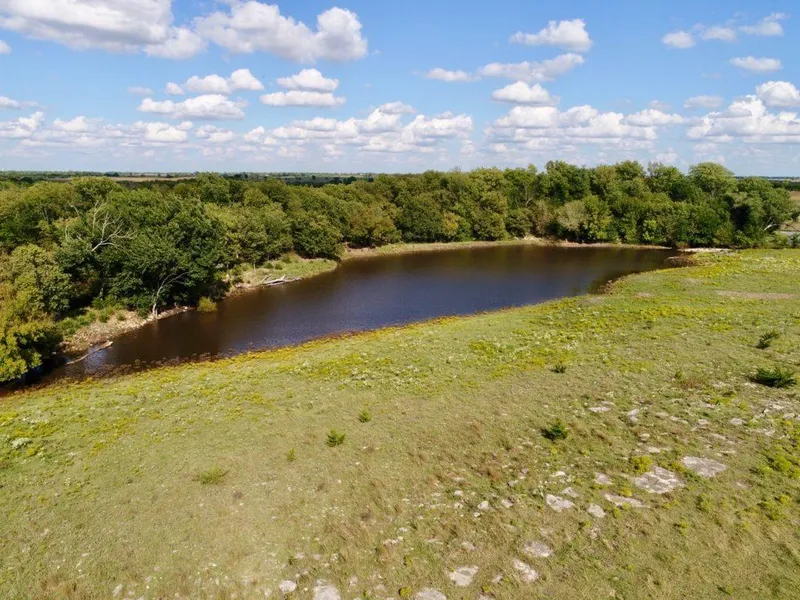
PROPERTY DESCRIPTION: 187.4 acres located just east of El Dorado Kansas near the El Dorado Lake. This diverse property has native Flint Hills pasture, really nice rolling hills and terrain, a good pond, wet weather draws and springs, and a windmill over a water well. Access is just a few hundred hards from blacktop HWY 54, but the terrain makes the property feel very secluded. Scattered timber offers good Kansas Whitetail Deer, Turkey, and Quail habitat. Great location, and an excellent combination of Agriculture and Recreation. Invest in Land!
LEGAL DESCRIPTION: Beginning at the Southeast corner of the Northeast Quarter of Section 6, Township 26 South, Range 6 East of the 6th PM, Butler County, Kansas; thence North 105.25 rods; thence West 117 rods; thence North 54.75 rods; thence West 3 rods; thence South 160 rods; thence East 120 rods to place of beginning; and the East Half of the Southeast Quarter of said Section 6, EXCEPT a tract being that part of the East Half of the Southeast Quarter of said Section 6 lying South and West of the El Dorado Eureka Highway, also known as U.S. Highway #54. Also, EXCEPT a tract beginning at a point 30 feet North of the Southeast corner of said Section 6; thence North 585 feet; thence West 740 feet; thence South to U.S. Highway #54, as now located; thence Southeasterly along said highway to point of beginning. Subject to public road AND The West Half of the Southwest Quarter of Section 5, Township 26 South, Range 6 East of the 6th PM, Butler County, Kansas, EXCEPT a tract beginning at the Southwest corner of said Section 5; thence East 544.5 feet; thence North 1184 feet; thence West 544.5 feet; thence South 1184 feet to the point of beginning. Subject to public road.
2017 REAL ESTATE TAXES: $501.70.
TERMS: Earnest money is $25,000 down at the conclusion of the Auction with the balance due upon Sellers submission of merchantable title and closing. Closing date shall be on or before November 30, 2018. Closing fee and title Insurance fee will be split 50/50 between Seller and Buyer. Selling subject to easements, restrictions, roadways and rights of way. This property is not selling subject to financing or inspections. Interested buyers need to view the property prior to the date of the auction and have financing available and any inspections performed prior to bidding. All pertinent information is available upon request. All announcements made the day of the auction take precedence over any other announcements or printed material.
From elevation to risk assessment
Search for detailed parcel information including; Elevation & Vegetation Maps, Ownership Information, Detailed Parcel Information, Crop History Map, Soil Survey Productivity Data, and more.
Research Parcel InformationDirections
LAND LOCATION: From El Dorado, East on HWY 54 1 1/2 Miles to SE River Rd, then northwest to the property. The property borders SE River Rd and SE Poor Farm Rd.
Resources
Land for Sale by Jeremy Sundgren
Butler County Properties By Type
- Ranches for Sale in Butler County, Kansas
- Farms for Sale in Butler County, Kansas
- Hunting Land for Sale in Butler County, Kansas
- Undeveloped Land for Sale in Butler County, Kansas
- Commercial Property for Sale in Butler County, Kansas
- Recreational Property for Sale in Butler County, Kansas
- Lakefront Property for Sale in Butler County, Kansas
- Riverfront Property for Sale in Butler County, Kansas
- Residential Property for Sale in Butler County, Kansas
- Horse Property for Sale in Butler County, Kansas
- Timberland for Sale in Butler County, Kansas
- Beachfront Property for Sale in Butler County, Kansas
Properties for Sale Nearby Counties
Butler County Properties By City
- Andover, Kansas Land for Sale
- Augusta, Kansas Land for Sale
- Beaumont, Kansas Land for Sale
- Benton, Kansas Land for Sale
- Cassoday, Kansas Land for Sale
- Douglass, Kansas Land for Sale
- El Dorado, Kansas Land for Sale
- Elbing, Kansas Land for Sale
- Latham, Kansas Land for Sale
- Leon, Kansas Land for Sale
- Potwin, Kansas Land for Sale
- Rosalia, Kansas Land for Sale
- More
- Rose Hill, Kansas Land for Sale
- Towanda, Kansas Land for Sale
- Whitewater, Kansas Land for Sale
- Aikman, Kansas Land for Sale
- Bloomington, Kansas Land for Sale
- Bois d' Arc, Kansas Land for Sale
- Brainerd, Kansas Land for Sale
- Chelsea, Kansas Land for Sale
- De Graff, Kansas Land for Sale
- East El Dorado, Kansas Land for Sale
- Gordon, Kansas Land for Sale
- Haverhill, Kansas Land for Sale
- Hopkins, Kansas Land for Sale
- Keighley, Kansas Land for Sale
- Lakeview Heights, Kansas Land for Sale
- Lorena, Kansas Land for Sale
- Mecca Acres, Kansas Land for Sale
- Midian, Kansas Land for Sale
- Pickrell Corner, Kansas Land for Sale
- Pontiac, Kansas Land for Sale
- Salter, Kansas Land for Sale
- Smileyville, Kansas Land for Sale
- Summit, Kansas Land for Sale
- Sunset Acres, Kansas Land for Sale
- Vanora, Kansas Land for Sale
- Wingate, Kansas Land for Sale