1,875 ACRES GRASSLAND 25 MILES NE OF BYERS CO 29 MILES S OF FORT MORGAN CO
Description
LEGAL: All of Sections 22, 23, and 27, Township 2 South, Range 58 West of the 6th PM County of Adams.
ACREAGE: 1.875.57 +/- Total Acres (per Adams County Assessor) there is no current survey of the Property.
1,413.10 acres is enrolled into the Conservation Reserve Program (CRP), 295 +/- acres is fenced for
pasture and 212 +/- acres in the creek bottom is cut for hay..
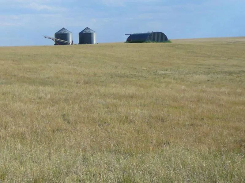
IMPROVEMENTS: 40’ x 70’ round top quonset with cement floor. 2-10,000 bushel grain bins with cement cones and all
material for erecting a third 10,000 bushel bin stored in the quonset.
PRICE: $1,970,000 or $1,050 per acre. Total annual income of $39.862.00
CRP INCOME: Property is enrolled in the Conservation Reserve Program (expiring 9/30/2030) paying $20,306.00
anually rent however it could be withdrawn for farming or grazing by paying a
PASTURE & Pasture & Hunting Lease Rent: Annuol cosh leose rent of S13,305.00 consisting of grozing lease rent
of $I3.00 per ocre on 295 ocres ond hunling cosh leose renl of $5.00 per ocre on 1,894 ocres.
WIND RENT: The Property is leased to NextEra Energy thru 9/21/30 for the potential of commercial wind tower
at an annual lease payment of $5,760 thru 2027 increasing to $9,600.00 per year thru 2030. If devel
oped, potentially one tower per 160+/- acres paying $15,000 per year. Development of the project
would allow for the CRP program, farming or grazing to continue.
WATER: Stock well 289177 located in the NW4SW4 of section 22 drilled in August of 2014 is 40 feet deep
and producing good stock water. Domestioc /stock well 335857 in NE4NE4 of Section 22 drilled
September of 2024 is 40 feet deep test pumped 10 gpm.
MINERALS: Property includes 100% minerals on section 22 pending on offer.
TAXES: 2025 taxes are $4,507 or $2.40 per acre.
NOTE: The information contained herein is reliable but not guaranteed by Seller or Broker. Broker is a Trans-
action (neutral) Broker.
From elevation to risk assessment
Search for detailed parcel information including; Elevation & Vegetation Maps, Ownership Information, Detailed Parcel Information, Crop History Map, Soil Survey Productivity Data, and more.
Research Parcel InformationDirections
LEGAL: All of Sections 22, 23, and 27, Township 2 South, Range 58 West of the 6th PM County of Adams. Property lies 25 miles NE of Byers and 29 miles miles S of Fort Morgan.
ADDRESS: 97240 E 96th Avenue, Fort Margan CO 80701.
LOCATION: From Shamrock CO go 1 mile S on Shamrock Mile Rd and 1 & 1/2 mile West to entrance (tire on post and Colorado Land Realty sign). 25 miles NE of Byers and 29 miles miles S of Fort Morgan.
LOCATION: From Byers CO go North on US Hwy 36 1&1/2 miles and follow Hwy 36 as curves East then continue East for another 11 miles to Hanks Crossing Rd then go North 9 miles to 96th Ave then go East 8 miles to the Property entrance on the South side. Watch for tire on post and Colorado Land Realty sign.
Environmental Factors
Adams County Properties By Type
- Undeveloped Land for Sale in Adams County, Colorado
- Ranches for Sale in Adams County, Colorado
- Farms for Sale in Adams County, Colorado
- Residential Property for Sale in Adams County, Colorado
- Commercial Property for Sale in Adams County, Colorado
- Horse Property for Sale in Adams County, Colorado
- Hunting Land for Sale in Adams County, Colorado
- Lakefront Property for Sale in Adams County, Colorado
- Riverfront Property for Sale in Adams County, Colorado
- Recreational Property for Sale in Adams County, Colorado
- Timberland for Sale in Adams County, Colorado
- Beachfront Property for Sale in Adams County, Colorado
Properties for Sale Nearby Counties
Adams County Properties By City
- Bennett, Colorado Land for Sale
- Brighton, Colorado Land for Sale
- Commerce City, Colorado Land for Sale
- Dupont, Colorado Land for Sale
- Eastlake, Colorado Land for Sale
- Henderson, Colorado Land for Sale
- Strasburg, Colorado Land for Sale
- Watkins, Colorado Land for Sale
- Westminster, Colorado Land for Sale
- Adams City, Colorado Land for Sale
- Federal Heights, Colorado Land for Sale
- Irondale, Colorado Land for Sale
- More
- Lochbuie, Colorado Land for Sale
- Northglenn, Colorado Land for Sale
- Thornton, Colorado Land for Sale
- Welby, Colorado Land for Sale
- Barr Lake, Colorado Land for Sale
- Berkeley Gardens, Colorado Land for Sale
- Berkley, Colorado Land for Sale
- Boston Heights, Colorado Land for Sale
- Cabin Creek, Colorado Land for Sale
- College Hills, Colorado Land for Sale
- Comanche, Colorado Land for Sale
- Cotton Creek, Colorado Land for Sale
- Cozy Corner, Colorado Land for Sale
- Derby, Colorado Land for Sale
- Eno, Colorado Land for Sale
- Fairview, Colorado Land for Sale
- Friendly Village, Colorado Land for Sale
- Gateway Park, Colorado Land for Sale
- Harris Park, Colorado Land for Sale
- Hazeltine, Colorado Land for Sale
- Hazeltine Heights, Colorado Land for Sale
- Hidden Creek Park, Colorado Land for Sale
- Hidden Lake, Colorado Land for Sale
- Hi-Land Acres, Colorado Land for Sale
- Hillcrest, Colorado Land for Sale
- Hillcrest Village, Colorado Land for Sale
- Holiday Hills Village, Colorado Land for Sale
- Homestead Heights, Colorado Land for Sale
- Kimberly Hills, Colorado Land for Sale
- Leader, Colorado Land for Sale
- Living Springs, Colorado Land for Sale
- Manila, Colorado Land for Sale
- Norfolk Glen, Colorado Land for Sale
- North Washington, Colorado Land for Sale
- Northborough Heights, Colorado Land for Sale
- Quail Hill, Colorado Land for Sale
- Quimby, Colorado Land for Sale
- Rolla, Colorado Land for Sale
- Sable, Colorado Land for Sale
- Shamrock, Colorado Land for Sale
- Shaw Heights, Colorado Land for Sale
- Sherrelwood, Colorado Land for Sale
- Skyline Vista, Colorado Land for Sale
- Sunset Ridge, Colorado Land for Sale
- Tennyson Park, Colorado Land for Sale
- Todd Creek, Colorado Land for Sale
- Utah Junction, Colorado Land for Sale
- Wandering View, Colorado Land for Sale
- Western Hills, Colorado Land for Sale
- Westminster Hills, Colorado Land for Sale
- Westview, Colorado Land for Sale
- Zuni, Colorado Land for Sale