Howard 197.94
Description
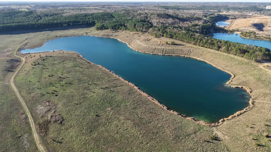
Introducing the Howard 197.94: an ultimate outdoor recreational tract located near Nashville in Southwest Arkansas. Once a gypsum mine, which this area is well known for, the 197.94 acre Howard County property consists of mostly open areas with some scattered pines, creating a very diverse and unusual landscape.
The highlight of this property is the crystal-clear 31 acre lake, which offers great fishing, boating, and duck hunting opportunities. A concrete boat ramp is in place for getting your watercraft to the water with ease.
The perimeter of the land is completely fenced and has been used as cattle pasture in the past. Infrastructure is in place for an RV or the beginning of a residence. This area is known for the large population and quality of whitetail deer, with there being several thousand adjacent acres that prohibit hunting; therefore, the age structure of the herd is exceptional.
If you are looking for the ultimate outdoor recreation tract, the Howard 197.94 is a true contender!
Contact Luke Alston today to learn more and schedule a private tour.
Location:
438 Nathan Road
Nashville, AR 71852
Howard County
9 Miles N of Nashville
11 Miles W of Murfreesboro
13 Miles W of the Crater of Diamonds State Park
16 Miles SW of Lake Greeson
25 Miles E of Dierks Lake
57 Miles N of Texarkana
118 Miles SW of Little Rock
225 Miles NE of Dallas, TX
Coordinates:
34.07085, -93.8262
Property Use:
Recreation
Hunting/Fishing
Potential Home Site
Cattle Pasture
Property Information:
197.94 Acres
31 Acre Lake
Concrete Boat Ramp
Electricity, RV Hookup and City Water
Fully Fenced with Multiple Gates
Adjacent to Large Tracts of Private Land
Paved County Road Frontage
Abundant Wildlife
Tax Information:
Parcel 001-01650-0020: $110.69
Parcel 001-01653-0030: $127.22
From elevation to risk assessment
Search for detailed parcel information including; Elevation & Vegetation Maps, Ownership Information, Detailed Parcel Information, Crop History Map, Soil Survey Productivity Data, and more.
Research Parcel InformationDirections
Environmental Factors
Resources
Howard County Properties By Type
- Lakefront Property for Sale in Howard County, Arkansas
- Riverfront Property for Sale in Howard County, Arkansas
- Farms for Sale in Howard County, Arkansas
- Ranches for Sale in Howard County, Arkansas
- Undeveloped Land for Sale in Howard County, Arkansas
- Recreational Property for Sale in Howard County, Arkansas
- Residential Property for Sale in Howard County, Arkansas
- Timberland for Sale in Howard County, Arkansas
- Commercial Property for Sale in Howard County, Arkansas
- Hunting Land for Sale in Howard County, Arkansas
- Horse Property for Sale in Howard County, Arkansas
- Beachfront Property for Sale in Howard County, Arkansas
Properties for Sale Nearby Counties
Howard County Properties By City
- Dierks, Arkansas Land for Sale
- Mineral Springs, Arkansas Land for Sale
- Nashville, Arkansas Land for Sale
- Saratoga, Arkansas Land for Sale
- Umpire, Arkansas Land for Sale
- Athens, Arkansas Land for Sale
- Center Point, Arkansas Land for Sale
- Okay, Arkansas Land for Sale
- Allbrook, Arkansas Land for Sale
- Atwood, Arkansas Land for Sale
- Baker Springs, Arkansas Land for Sale
- Bethany, Arkansas Land for Sale
- More
- Blue Bayou, Arkansas Land for Sale
- Briar, Arkansas Land for Sale
- Buck Range, Arkansas Land for Sale
- Burg, Arkansas Land for Sale
- Davis Ford, Arkansas Land for Sale
- Duckett, Arkansas Land for Sale
- Duckett Ford, Arkansas Land for Sale
- Euclid, Arkansas Land for Sale
- Faulkner Springs, Arkansas Land for Sale
- Galena, Arkansas Land for Sale
- Green Plains, Arkansas Land for Sale
- Henry, Arkansas Land for Sale
- Mineola, Arkansas Land for Sale
- Mount Carmel, Arkansas Land for Sale
- Muddy Fork, Arkansas Land for Sale
- Perkins, Arkansas Land for Sale
- Schaal, Arkansas Land for Sale
- Schooley, Arkansas Land for Sale
- Temperanceville, Arkansas Land for Sale
- Tollette, Arkansas Land for Sale
- Unity, Arkansas Land for Sale