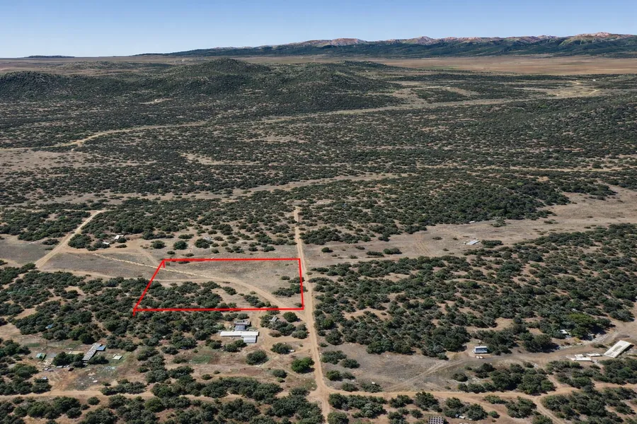
2.36 Acres in Cotopaxi, Colorado
Description
Owner Financing Available - This 2.36 acre lot is located in Cotopaxi, Colorado and the address is 6th Trail, Cotopaxi, CO 81223.
Cotopaxi is a tiny, unincorporated community in Fremont County, Colorado, located in the heart of the state's rugged high country. It's not a town or city with a formal government but rather a census-designated place (CDP) centered around a post office, a few businesses, and scattered homes. It sits along the scenic Arkansas River, making it a popular stop for outdoor enthusiasts.
Features: Treed lot, mountain backdrop, road access
Only $2750 Down and $550/month for 56 months = $33550 or Discounted Cash Price: $27497
PROPERTY DETAILS
APN: 98704090
Address: 6th Trail, Cotopaxi, CO 81223
County: Fremont
State: Colorado
Size: 2.36 Acres
Dimensions: 332' x 310'
Legal: Subd: Florida Colo Acres Sw4 Ne4 Sw4 Nw4 Sec 27 20 73 Fla Colo Acres Tr 78
Terrain: Gently Rolling
Access: Dirt Road
Power: Power in the Area (Power Company: Black Hills Energy: 1-888-890-5554)
Water: Water in the Area (Water On The Spot: (719) 275-7015) (Well: American Drilling Service: (719) 942-3568) (Water Haul: Wood & Water: (719) 298-0482)
Sewer: Sewer or Septic in the Area (Septic: KW & Sons Excavating: (719) 207-5983)
Taxes per Year: $290
HOA Fees per Year: No HOA/POA
GPS Coordinates (center) at the road: 38.287556, -105.533665
--- Northwest Corner: 38.288012, -105.534208
--- Northeast Corner: 38.287991, -105.533120
--- Southwest Corner: 38.287103, -105.534194
--- Southeast Corner: 38.287086, -105.533116
Elevation: 7888
BUILDING INFORMATION
Zoning: CO-Fremont-R-1-Residential
Time Limit to Build: No time limit to build
Site Built Homes Allowed: Allowed 400 min sqft
Modular Homes Allowed: Allowed 400 min sqft
Manufactured Homes Allowed: Allowed 400 min sqft
Mobile Homes Allowed: Allowed 400 min sqft
Tiny Homes Friendly: Allowed 400 min sqft
ALLOWABLE USES
Full-Time RV Living Allowed: Not Allowed
RV on the Property While I build: Not Allowed
Camping in a RV Allowed: Allowed Max 14 days
From elevation to risk assessment
Search for detailed parcel information including; Elevation & Vegetation Maps, Ownership Information, Detailed Parcel Information, Crop History Map, Soil Survey Productivity Data, and more.
Research Parcel InformationDirections
From Westcliffe, CO 81252, USA
1.Head north on CO-69 N/3rd St toward North Ave
2.Turn right onto Copper Gulch Rd
3.Turn left onto Reed Rd
4.Turn right onto S Path
5.S Path turns right and becomes 8th Trail
6.Turn left
7.Lot is on the left
Environmental Factors
Resources
Fremont County Properties By Type
- Undeveloped Land for Sale in Fremont County, Colorado
- Riverfront Property for Sale in Fremont County, Colorado
- Lakefront Property for Sale in Fremont County, Colorado
- Ranches for Sale in Fremont County, Colorado
- Residential Property for Sale in Fremont County, Colorado
- Recreational Property for Sale in Fremont County, Colorado
- Hunting Land for Sale in Fremont County, Colorado
- Farms for Sale in Fremont County, Colorado
- Commercial Property for Sale in Fremont County, Colorado
- Timberland for Sale in Fremont County, Colorado
- Horse Property for Sale in Fremont County, Colorado
- Beachfront Property for Sale in Fremont County, Colorado
Properties for Sale Nearby Counties
Fremont County Properties By City
- Canon City, Colorado Land for Sale
- Coal Creek, Colorado Land for Sale
- Coaldale, Colorado Land for Sale
- Cotopaxi, Colorado Land for Sale
- Florence, Colorado Land for Sale
- Hillside, Colorado Land for Sale
- Howard, Colorado Land for Sale
- Penrose, Colorado Land for Sale
- Rockvale, Colorado Land for Sale
- Buckskin Joe, Colorado Land for Sale
- Portland, Colorado Land for Sale
- Prospect Heights, Colorado Land for Sale
- More
- Texas Creek, Colorado Land for Sale
- Williamsburg, Colorado Land for Sale
- Adelaide, Colorado Land for Sale
- Brookside, Colorado Land for Sale
- Concrete, Colorado Land for Sale
- East Canon, Colorado Land for Sale
- Echo, Colorado Land for Sale
- Fink, Colorado Land for Sale
- Galena, Colorado Land for Sale
- Lincoln Park, Colorado Land for Sale
- Orchard Park, Colorado Land for Sale
- Park Center, Colorado Land for Sale
- Pleasanton, Colorado Land for Sale
- Sample, Colorado Land for Sale
- Sikes, Colorado Land for Sale
- Sunset City, Colorado Land for Sale
- Vallie, Colorado Land for Sale
- Whitehorn, Colorado Land for Sale
- Yorkville, Colorado Land for Sale