20 acres in Okanogan County, Washington
Please Call Nick Sliger 480 360-5940
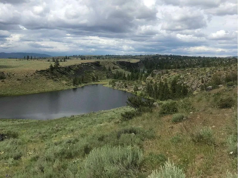
Look no further for a private, off-grid property with seasonal surface water, offered at below market value. This property is surrounded by lakes and has scattered pine trees, with a grove of trees at the center. A seasonal pond on the southern part of the property fills from the winter snow-melt and beautiful views of the nearby lake. Increase the size of your pond for additional water throughout the year. Live like Henry David Thoreau and build a cabin next to your pond.
This property will allow you to get away from it all and spend time in the unspoiled natural beauty of the nearby National Forest. Okanogan County is prime for outdoor adventures, with nearby Lake Pateros and Lake Omak both offering great camping, boating, and fishing. There are also hunting opportunities during the season. You can get out on you horse, ATV, or dirt bike and explore miles of roads, open range, and forests. The nearby towns of Okanogan, Omak, and Brewster provide services and amenities like shopping, medical care, and restaurants.
This property was purchased with title insurance. Power is on the property and available through Nespelem Valley Electric Cooperative. There is a power pole on the Northeast corner of the lot. The property has physical access but not legal deeded access which is reflected in the discounted price. Property is located on the Colville Reservation with Fee Simple ownership, the highest level of ownership allowing for full use of the land. The wells in the area are drilled to a depth of 300 feet. Buyer to perform due diligence.
Directions: To view the property, post the GPS 48.241746, -119.54461 in Google maps.
GPS Corner Points: 48.2426775211616,-119.54732257758; 48.2408679574959,-119.547315253597; 48.2408135997957,-119.541897924846; 48.2426231639524,-119.54190508767
Size (Acres): 20
General Location: 14 miles Northeast of Brewster, WA
APN or Other ID: 3226272009
Legal Description: SEC 27 TWN 32 RNG 26 S1/2 NW SE
GPS: 48.241746, -119.54461
Property Type: Rural
Zoning: Undeveloped Land
Terrain: Rolling Hills
General Elevation: 2650
Power: Solar/Alternative
Phone: Mobile/Satellite/Alternative
Water: Well/Alternative
Sewer: Septic/Alternative
Roads: Dirt/4x4
Time Limit to Build: No Limit
Annual Property Taxes (Approx): $327.16
Document Fees: $0 on Cash
Terms: Cash Sale Only
From elevation to risk assessment
Search for detailed parcel information including; Elevation & Vegetation Maps, Ownership Information, Detailed Parcel Information, Crop History Map, Soil Survey Productivity Data, and more.
Research Parcel InformationEnvironmental Factors
Resources
Land for Sale by Landcurator
Okanogan County Properties By Type
- Undeveloped Land for Sale in Okanogan County, Washington
- Residential Property for Sale in Okanogan County, Washington
- Riverfront Property for Sale in Okanogan County, Washington
- Recreational Property for Sale in Okanogan County, Washington
- Ranches for Sale in Okanogan County, Washington
- Commercial Property for Sale in Okanogan County, Washington
- Farms for Sale in Okanogan County, Washington
- Timberland for Sale in Okanogan County, Washington
- Lakefront Property for Sale in Okanogan County, Washington
- Beachfront Property for Sale in Okanogan County, Washington
- Hunting Land for Sale in Okanogan County, Washington
- Horse Property for Sale in Okanogan County, Washington
Properties for Sale Nearby Counties
Okanogan County Properties By City
- Brewster, Washington Land for Sale
- Carlton, Washington Land for Sale
- Conconully, Washington Land for Sale
- Coulee Dam, Washington Land for Sale
- Elmer City, Washington Land for Sale
- Loomis, Washington Land for Sale
- Malott, Washington Land for Sale
- Mazama, Washington Land for Sale
- Methow, Washington Land for Sale
- Nespelem, Washington Land for Sale
- Okanogan, Washington Land for Sale
- Omak, Washington Land for Sale
- More
- Oroville, Washington Land for Sale
- Pateros, Washington Land for Sale
- Riverside, Washington Land for Sale
- Tonasket, Washington Land for Sale
- Twisp, Washington Land for Sale
- Wauconda, Washington Land for Sale
- Winthrop, Washington Land for Sale
- Aeneas, Washington Land for Sale
- Bodie, Washington Land for Sale
- Chesaw, Washington Land for Sale
- Disautel, Washington Land for Sale
- Havillah, Washington Land for Sale
- Mason City, Washington Land for Sale
- Molson, Washington Land for Sale
- Monse, Washington Land for Sale
- Nighthawk, Washington Land for Sale
- Synarep, Washington Land for Sale
- Anglin, Washington Land for Sale
- Barker, Washington Land for Sale
- Belvedere, Washington Land for Sale
- Brown Lake, Washington Land for Sale
- Cherokee, Washington Land for Sale
- Chillowist, Washington Land for Sale
- Chopaka, Washington Land for Sale
- Cordell, Washington Land for Sale
- Ellisforde, Washington Land for Sale
- Enterprise, Washington Land for Sale
- Gilbert, Washington Land for Sale
- Janis, Washington Land for Sale
- Keystone, Washington Land for Sale
- Koontzville, Washington Land for Sale
- Lone Pine, Washington Land for Sale
- Mowich Illahee, Washington Land for Sale
- North Omak, Washington Land for Sale
- Old Toroda, Washington Land for Sale
- Old Wauconda, Washington Land for Sale
- Olema, Washington Land for Sale
- Ophir, Washington Land for Sale
- Paradise Hill, Washington Land for Sale
- Seatons Grove, Washington Land for Sale
- Starr, Washington Land for Sale
- Vanderpool Crossing, Washington Land for Sale
- Wakefield, Washington Land for Sale