Prime Turn-Key Hunting Property With Big Buck History
Description
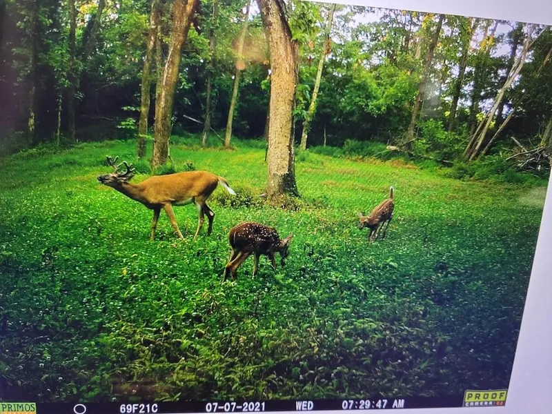
If you’ve been searching for a quality hunting or outdoor recreational property that won’t break the bank, this is one you won’t want to miss. Located near the southern border of Pike County, this small property hunts big thanks to the adjacent Sugar Ridge Fish and Wildlife Area. Currently, under restricted access, this 2,000+ acre refuge supports a thriving deer and turkey population, enhancing the hunting opportunities off this tract.The sellers have taken great care to maximize the property’s potential, strategically installing a perfectly located -acre clover plot in the northwest corner. This setup capitalizes on the property’s position within the neighborhood and aligns with the historical travel patterns of big bucks. In addition, they’ve installed a 200-amp electric service, created a spacious parking area for a camper or RV, and established a base drivewaymaking this a true turnkey setup.A small, spring-fed creek runs across the southern end of the property, providing a year-round water source for wildlife. With over 650 feet of county road frontage, the land features gently rolling topography, an internal trail network, ideal locations for additional food plots, and multiple potential build sites for a small hunting cabin or country retreat.The sellers have also compiled an impressive trail cam and harvest history that speaks to the quality of the local deer herd and the strong age class of bucks in the area. One look at the pictures, and you’ll see that this property can produce trophy-caliber deer year after year.For those who enjoy foraging, wild edibles such as morel mushrooms and blackberries can be found at certain times of the year. Don’t underestimate what you can accomplish on a small propertythis tract can out-hunt much larger ones with the right strategy. If you’d rather have the right 20 acres than the wrong 200, this might be the one for you!
From elevation to risk assessment
Search for detailed parcel information including; Elevation & Vegetation Maps, Ownership Information, Detailed Parcel Information, Crop History Map, Soil Survey Productivity Data, and more.
Research Parcel InformationEnvironmental Factors
Resources
Pike County Properties By Type
- Undeveloped Land for Sale in Pike County, Indiana
- Hunting Land for Sale in Pike County, Indiana
- Lakefront Property for Sale in Pike County, Indiana
- Farms for Sale in Pike County, Indiana
- Ranches for Sale in Pike County, Indiana
- Residential Property for Sale in Pike County, Indiana
- Riverfront Property for Sale in Pike County, Indiana
- Timberland for Sale in Pike County, Indiana
- Recreational Property for Sale in Pike County, Indiana
- Commercial Property for Sale in Pike County, Indiana
- Horse Property for Sale in Pike County, Indiana
- Beachfront Property for Sale in Pike County, Indiana
Properties for Sale Nearby Counties
Pike County Properties By City
- Otwell, Indiana Land for Sale
- Petersburg, Indiana Land for Sale
- Spurgeon, Indiana Land for Sale
- Stendal, Indiana Land for Sale
- Velpen, Indiana Land for Sale
- Winslow, Indiana Land for Sale
- Alford, Indiana Land for Sale
- Algiers, Indiana Land for Sale
- Arthur, Indiana Land for Sale
- Ayrshire, Indiana Land for Sale
- Bowman, Indiana Land for Sale
- Cato, Indiana Land for Sale
- More
- Glezen, Indiana Land for Sale
- Logan, Indiana Land for Sale
- Muren, Indiana Land for Sale
- West Petersburg, Indiana Land for Sale
- Whiteoak, Indiana Land for Sale
- Willisville, Indiana Land for Sale
- Arda, Indiana Land for Sale
- Ashby Yards, Indiana Land for Sale
- Bartons Location, Indiana Land for Sale
- Campbelltown, Indiana Land for Sale
- Coats Spring, Indiana Land for Sale
- Coe, Indiana Land for Sale
- Enos Corner, Indiana Land for Sale
- Fritz Corner, Indiana Land for Sale
- Hartwell, Indiana Land for Sale
- Hartwell Junction, Indiana Land for Sale
- Highbank Town, Indiana Land for Sale
- Iva, Indiana Land for Sale
- Littles, Indiana Land for Sale
- Oakland City Junction, Indiana Land for Sale
- Pikeville, Indiana Land for Sale
- Rogers, Indiana Land for Sale
- Rumble, Indiana Land for Sale
- Survant, Indiana Land for Sale
- Union, Indiana Land for Sale
- White Sulphur Springs, Indiana Land for Sale