Rimcrest on St Charles River
193 ACRES ON 1 MILE OF ST. CHARLES RIVER RIM-TOP GRAIN SILO GLAMPING WITH EPIC CANYON VIEWS!
Pueblo, CO | 193 Deeded Acres | Loft Silo | Furnished | Off-Grid Solar
Perched on the dramatic rim of a 100-ft canyon, this 193-acre riverfront ranch offers one full mile of both sides of the St. Charles River winding through a lush, grassed valley below. A charming converted grain silo has been glamped-up into a rustic livable space.
Land
193 contiguous deeded acres
1 mile of private St. Charles River frontage (both banks) with pinon, juniper, willows, and grassy meadows
100 ft of elevation change: rim-top plateau (5,500 ft) down to fertile river bottom (5,400 ft)
Diverse terrain: pion-juniper ridges, hidden draws, and south-facing slopes
No HOA | No conservation easement |
Improvements
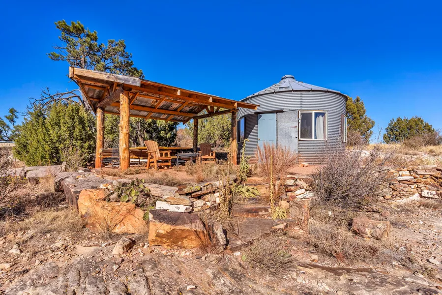
Glamped-up Grain silo Charming and rustic grain silo converted to glamped-up space with indoor conveniences from the elements
Fully insulated, wood-finished interior
Partially furnished
20-ft covered front deck with Adirondack chairs and fire pitNice covered front deck perfect to overlook the beautiful canyon below where the St. Charles River meanders through the beautiful grassed river valley
Shaded ramada with picnic table, and BBQ
Gravel driveway and buildable homesites with 360 views
Recreation
Mule deer hunting GMU 84 (Trophy Unit)
Landowner qualifies for Mule Deer, Elk, Pronghorn hunting licenses.(Generally gets one of the three species but this is not guaranteed)
Private river access for fishing or gold panning
Hiking, horseback, and ATV trails from your doorstep to the canyon bottom
Bortle 2 dark skies Experience the amazing dark skies of this beautiful wild country
Agriculture
River bottom meadow nice for a small cattle operation
Private Fishing!
Region & Climate
Location Overview
Rimcrest on The St Charles River is located just Southwest of Pueblo, Colorado, in Pueblo County, on the eastern plains of the state. This semi-arid region is at about 5,200 feet elevation, influenced by the rain shadow of the Rocky Mountains to the west. It features abundant sunshine (over 3,600 hours annually), low humidity, and a large diurnal temperature swing (up to 40F daily). Historical data is based on records from Pueblo Memorial Airport (19912020 normals, with some dating back to 1888).
Climate Classification and General Patterns
Semi-Arid Steppe Climate: Dry overall, with low precipitation (1218 inches/305457 mm annually) and moderate temperatures. About 75% of rain falls AprilSeptember via thunderstorms; winters are dry and cold, with March as the snowiest month and April/May the wettest.
Variability: Elevation creates microclimateslower plains like this area get hotter summers and less snow than nearby foothills. Chinook winds can cause rapid winter warm-ups (up to 70F/21C). The area is on the edge of Tornado Alley, prone to hail, high winds, and occasional floods from intense storms.
Trends: Recent decades show increasing drought frequency, more extreme heat (hot days now outnumber cold ones 3:1), and variable snowfall due to climate change.
Temperature Patterns
Pueblo’s climate is continental, with hot summers and cold winters. More than half of summer days exceed 90F (32C). Average annual temperature: ~53.5F (11.9C).
Month
Avg High (F/C)
Avg Low (F/C)
Record High (F/C)
Record Low (F/C)
January
47 / 8
14 / -10
78 / 26 (2020)
-31 / -35 (1951)
February
51 / 11
18 / -8
79 / 26 (2020)
-20 / -29 (various)
March
60 / 16
27 / -3
88 / 31 (2017)
-15 / -26 (various)
April
68 / 20
35 / 2
94 / 34 (various)
10 / -12 (various)
May
78 / 26
45 / 7
100 / 38 (various)
21 / -6 (various)
June
89 / 32
55 / 13
108 / 42 (various)
32 / 0 (various)
July
93 / 34
59 / 15
109 / 43 (2003)
48 / 9 (various)
August
90 / 32
58 / 14
105 / 41 (various)
45 / 7 (various)
September
83 / 28
49 / 9
102 / 39 (various)
26 / -3 (various)
October
71 / 22
37 / 3
95 / 35 (various)
14 / -10 (various)
November
58 / 14
24 / -4
82 / 28 (various)
-5 / -21 (various)
December
48 / 9
15 / -9
71 / 22 (various)
-15 / -26 (2022)
Source: NOAA 19912020 normals; extremes from 18882023 records.
Precipitation and Snowfall Patterns
Annual precipitation averages ~13 inches (330 mm), mostly from convective thunderstorms (JuneAugust peak). Snowfall is light compared to the mountains, averaging ~32 inches (81 cm) per year, concentrated NovemberMarch.
Month
Avg Precipitation (in/mm)
Rainy Days
Avg Snowfall (in/cm)
January
0.3 / 8
3
3.5 / 9
February
0.4 / 10
4
4.0 / 10
March
0.9 / 23
5
4.5 / 11
April
1.5 / 38
6
2.0 / 5
May
1.8 / 46
7
0.5 / 1
June
1.5 / 38
6
0.0 / 0
July
1.9 / 48
7
0.0 / 0
August
1.7 / 43
7
0.0 / 0
September
1.1 / 28
5
0.5 / 1
October
0.7 / 18
4
1.5 / 4
November
0.5 / 13
3
2.5 / 6
December
0.4 / 10
3
3.0 / 8
Annual totals: 13.2 in precip / 335 mm; 32 in snow / 81 cm. July is wettest; January driest.
Location
25 minutes to Pueblo (Walmart, hospitals, airport)
25 minutes to Rye (school, caf, post office)
25minutes to Beulah Valley (San Isabel Lake, dining)
From elevation to risk assessment
Search for detailed parcel information including; Elevation & Vegetation Maps, Ownership Information, Detailed Parcel Information, Crop History Map, Soil Survey Productivity Data, and more.
Research Parcel InformationDirections
Resources
Land for Sale by Twila Geroux
Pueblo County Properties By Type
- Ranches for Sale in Pueblo County, Colorado
- Undeveloped Land for Sale in Pueblo County, Colorado
- Farms for Sale in Pueblo County, Colorado
- Hunting Land for Sale in Pueblo County, Colorado
- Residential Property for Sale in Pueblo County, Colorado
- Commercial Property for Sale in Pueblo County, Colorado
- Lakefront Property for Sale in Pueblo County, Colorado
- Horse Property for Sale in Pueblo County, Colorado
- Riverfront Property for Sale in Pueblo County, Colorado
- Recreational Property for Sale in Pueblo County, Colorado
- Timberland for Sale in Pueblo County, Colorado
- Beachfront Property for Sale in Pueblo County, Colorado
Properties for Sale Nearby Counties
- Crowley County, Colorado Land for Sale
- Custer County, Colorado Land for Sale
- El Paso County, Colorado Land for Sale
- Fremont County, Colorado Land for Sale
- Huerfano County, Colorado Land for Sale
- Las Animas County, Colorado Land for Sale
- Lincoln County, Colorado Land for Sale
- Otero County, Colorado Land for Sale
Pueblo County Properties By City
- Avondale, Colorado Land for Sale
- Beulah, Colorado Land for Sale
- Boone, Colorado Land for Sale
- Colorado City, Colorado Land for Sale
- Pueblo, Colorado Land for Sale
- Rye, Colorado Land for Sale
- Baxter, Colorado Land for Sale
- Blende, Colorado Land for Sale
- Cedarwood, Colorado Land for Sale
- Devine, Colorado Land for Sale
- North Avondale, Colorado Land for Sale
- Pueblo West, Colorado Land for Sale
- More
- Vineland, Colorado Land for Sale
- Beulah Valley, Colorado Land for Sale
- Bragdon, Colorado Land for Sale
- Bronquist, Colorado Land for Sale
- Burnt Mill, Colorado Land for Sale
- Cedar Crest, Colorado Land for Sale
- Cedar Grove, Colorado Land for Sale
- Cuerna Verde Park, Colorado Land for Sale
- Eden, Colorado Land for Sale
- Fearnowville, Colorado Land for Sale
- Fort Reynolds, Colorado Land for Sale
- Goodnight, Colorado Land for Sale
- Goodpasture, Colorado Land for Sale
- Greenhorn, Colorado Land for Sale
- Hamlet, Colorado Land for Sale
- Henkel, Colorado Land for Sale
- Hobson, Colorado Land for Sale
- Lombard Village, Colorado Land for Sale
- Nepesta, Colorado Land for Sale
- Nyberg, Colorado Land for Sale
- Piñon, Colorado Land for Sale
- Rock Crossing, Colorado Land for Sale
- Saint Charles, Colorado Land for Sale
- Salt Creek, Colorado Land for Sale
- Siloam, Colorado Land for Sale
- Stem Beach, Colorado Land for Sale
- Stone City, Colorado Land for Sale
- Swallows, Colorado Land for Sale
- Valley View, Colorado Land for Sale
- Whiterock, Colorado Land for Sale
