Auction Information
208 acres in Clay County, Minnesota
FARMLAND AUCTION
208 +/- Acres - Clay County, MN
Tuesday, November 24, 2015 - 11:00 a.m. (CT)
Auction Location: Pifers Corporate Office 1506 29th Ave S. - Moorhead, MN
Property Note: This property features 190 +/- acres of excellent farmland east of Georgetown, MN in Clay County. Available to be farmed in 2016! As a farmer or investor, take advantage of this perfect opportunity to expand your operation with this great farmland.
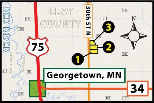
Driving Directions:
-Parcel 1: From Georgetown, MN: Drive east on HWY #34 for 3 miles to 30th St. N, then turn left and drive north for 2 miles to 180th Ave N. This will put you at the southwest corner of Parcel 1.
-Parcel 2 is contiguously located to the north of Parcel 1.
-Parcel 3 is contiguously located to the north of Parcel 2.
Property Information:
PARCEL 1
Acres: 80 +/-
Legal: S SW of 14-142-48 (Clay County, MN)
Cropland: 70 +/-
Soil Productivity Index: 90.6
Taxes (2014): $33.05/ac. (estimate)
Parcel ID #: 09.014.3000 (Parcels 1 & 2 Combined)
Description: Excellent cropland with great access!
OWNER: Mildred Kolness Revocable Living Trust
PARCEL 2
Acres: 80 +/-
Legal: N SW of 14-142-48 (Clay County, MN)
Cropland: 73.2 +/-
Soil Productivity Index: 88.2
Taxes (2014): $33.05/ac. (estimate)
Parcel ID #: 09.014.3000 (Parcels 1 & 2 Combined)
Description: Excellent cropland with great access!
OWNER: Mildred Kolness Revocable Living Trust
PARCEL 3
Acres: 48 +/-
Legal: Part of S NW of 14-142-48 (Clay County, MN)
Cropland: 47.2 +/-
Soil Productivity Index: 90.6
Taxes (2014): $22.10/ac.
Parcel ID #: 09.014.2300
Description: Excellent cropland with great access and a fantastic opportunity for building sites! Near Georgetown, MN and only a short 20 minute drive to downtown Fargo-Moorhead!
OWNERS: Donovan & Becky Kolness
OWNERS: Mildred Kolness Revocable Living Trust (&) Donovan and Becky Kolness
This sale is managed by Pifer's Auction Company, Kevin Pifer, MN #14-106. All statements made the day of the auction take precedence over all printed materials. The seller reserves the right to reject or accept any and all bids.
From elevation to risk assessment
Search for detailed parcel information including; Elevation & Vegetation Maps, Ownership Information, Detailed Parcel Information, Crop History Map, Soil Survey Productivity Data, and more.
Research Parcel InformationDirections
Driving Directions:
-Parcel 1: From Georgetown, MN: Drive east on HWY #34 for 3 miles to 30th St. N, then turn left and drive north for 2 miles to 180th Ave N. This will put you at the southwest corner of Parcel 1.
-Parcel 2 is contiguously located to the north of Parcel 1.
-Parcel 3 is contiguously located to the north of Parcel 2.
Environmental Factors
Land for Sale by Kevin Pifer
Clay County Properties By Type
- Farms for Sale in Clay County, Minnesota
- Lakefront Property for Sale in Clay County, Minnesota
- Residential Property for Sale in Clay County, Minnesota
- Undeveloped Land for Sale in Clay County, Minnesota
- Ranches for Sale in Clay County, Minnesota
- Hunting Land for Sale in Clay County, Minnesota
- Recreational Property for Sale in Clay County, Minnesota
- Riverfront Property for Sale in Clay County, Minnesota
- Timberland for Sale in Clay County, Minnesota
- Horse Property for Sale in Clay County, Minnesota
- Commercial Property for Sale in Clay County, Minnesota
- Beachfront Property for Sale in Clay County, Minnesota
Properties for Sale Nearby Counties
Clay County Properties By City
- Barnesville, Minnesota Land for Sale
- Comstock, Minnesota Land for Sale
- Dilworth, Minnesota Land for Sale
- Felton, Minnesota Land for Sale
- Georgetown, Minnesota Land for Sale
- Glyndon, Minnesota Land for Sale
- Hawley, Minnesota Land for Sale
- Hitterdal, Minnesota Land for Sale
- Moorhead, Minnesota Land for Sale
- Sabin, Minnesota Land for Sale
- Ulen, Minnesota Land for Sale
- Averill, Minnesota Land for Sale
- More
- Baker, Minnesota Land for Sale
- Dale, Minnesota Land for Sale
- Downer, Minnesota Land for Sale
- Kragnes, Minnesota Land for Sale
- Rollag, Minnesota Land for Sale
- Finkle, Minnesota Land for Sale
- Greenwood Communities, Minnesota Land for Sale
- Manitoba Junction, Minnesota Land for Sale
- Muskoda, Minnesota Land for Sale
- Rustad, Minnesota Land for Sale
- Tansem, Minnesota Land for Sale
- Winnipeg Junction, Minnesota Land for Sale