22.89 Acres for Sale in Lincoln County West Virginia for $665.11 a month!!
22.89 Acres for Sale in Lincoln County West Virginia for $665.11 a month!!
Owner Financing May Be Available!
Contact us Today!!
If you are interested in purchasing this property, call, text or E-mail us now to sign the contract, and send the deposit! (540) 824-3372
Owner financing may be available upon transfer of title.
Feel free to visit the property any time, no need to set up an appointment, this property has no address.
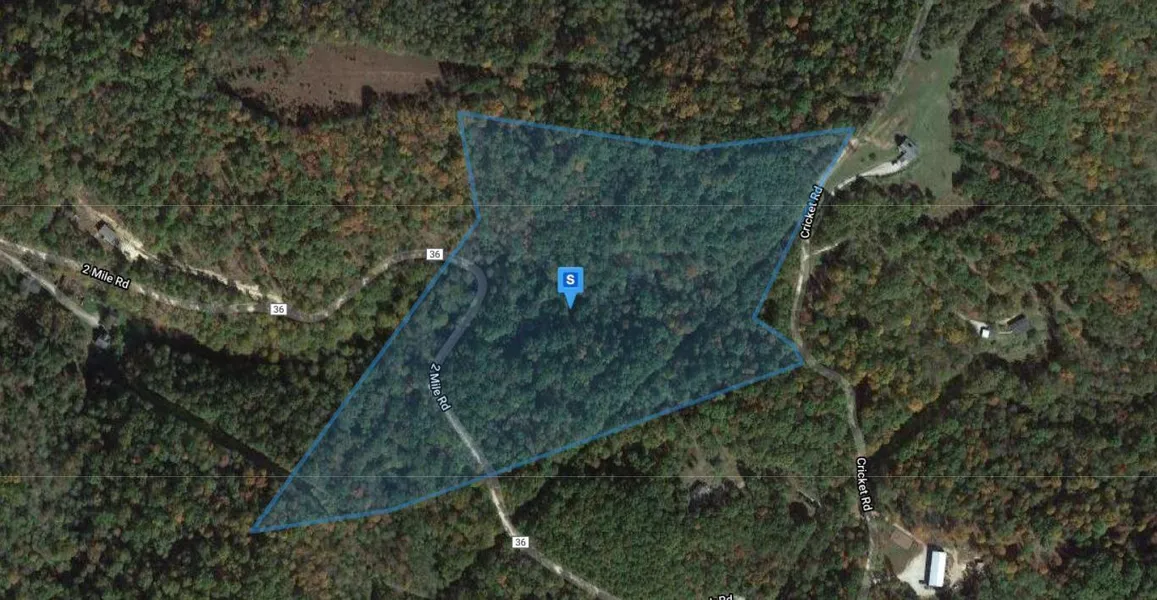
Special ad notes: Recent Survey of this property just completed and is available upon request.
Address: Route 36, Branchland, WV 25506
Cash Discount Price: $29,900.00
Owner Financing Terms: $5,000 down and $665.11 per month for 60 months, $20/ month loan servicing fee, 12% interest
County: Lincoln
Acres: 22.89 Acres (Raw Land)
Coordinates: 38.2200785312897 -82.1551655312788
Parcel #: 07-16-00190000
Yearly Taxes: $152.66
Legal Description: BEGINNING AT A BLACK GUM, A CORNER TO W.W. RAY AND CHARLES ARIX; THENCE WITH THE LINES OF CHARLES ARIX AND C.B. MEAD, AND BINDING THEREON N 84-3/4 E 1700 FEET TO A WHITE OAK 10 FEET WEST OF ROAD, CORNER TO LANDS OF C.B. MEAD AND O. MILLER; THENCE WITH THE LINE OF O. MILLER AND BINDING THEREON N 53 W 260 FEET TO CALL OF A HICKORY (GONE); THENCE N 21 E 605 FEET TO A WHITE OAK ON EDGE OF ROAD, CORNER TO LANDS OF O. MILLER AND LEE FRY; THENCE LEAVING THE LINE OF THE SAID O. MILLER, AND WITH THE LINE OF LEE FRY, AND BINDING THEREON S 78 W 350 FEET TO CALL OF A WHITE OAK (GONE) ON RIDGE; THENCE N 50-1/2W 685 FEET TO A MARKED ROCK AT CALL OF A BLACK OAK AND DOGWOOD (GONE), CORNER TO LEE FRYS LAND; THENCE S 1-1/2 W 305 FEET TO THREE BLACK OAKS ON THE SOUTH SIDE OF A POINT, CORNER TO LEE FRYS LAND; THENCE S 42-3/4 W 820 FEET TO CALL OF A BEECH BY BRANCH (GONE), CORNER TO MARY A. BRUMFIELD AND W.W. RAY LANDS; THENCE WITH THE LINE OF W.W. RAY AND BINDING THEREON S 46 W 289 FEET TO A STAKE; THENCE S 28 W 146 FEET TO THE BEGINNING, CONTAINING 23.4 ACRES, MORE OR LESS.
Zoning: No Zoning
Elevation: 873 ft.
County Planning and zoning phone #: Phone: (304) 824-7990 Ext. 221 (County Commission)
Phone: (304) 824-7999 Ext. 242 (Building Permit)
Survey info: No survey available
Does this property have an HOA?: No
Elementary school: WEST HAMLIN ELEMENTARY
Middle school: GUYAN VALLEY MIDDLE
High school: LINCOLN COUNTY HIGH SCHOOL
Phone # for electric company: APPALACHIAN POWER 800.956.4237
If this property is not what you are looking for, go to our website and sign up for our deal alerts; you will be notified whenever we have a new property for sale! Or, e-mail, call or text us, and we may be able to find the property you are looking for.
From elevation to risk assessment
Search for detailed parcel information including; Elevation & Vegetation Maps, Ownership Information, Detailed Parcel Information, Crop History Map, Soil Survey Productivity Data, and more.
Research Parcel InformationDirections
Branchland
West Virginia 25506, USA
Head east on 4 Mile Creek Rd toward State Hwy 10 N
128 ft
Turn right onto State Hwy 10 S
413 ft
Turn left onto 4 Mile Creek Rd
410 ft
Continue onto Hubball Rd
348 ft
Turn left onto Sheridan Rd
1.4 mi
Slight right onto 2 Mile Rd
2.6 mi
Turn right onto 2 Mile Rd/Little Laurel Creek Rd
Destination will be on the left
0.4 mi
Resources
Land for Sale by Luke Harris
Lincoln County Properties By Type
- Farms for Sale in Lincoln County, West Virginia
- Residential Property for Sale in Lincoln County, West Virginia
- Undeveloped Land for Sale in Lincoln County, West Virginia
- Ranches for Sale in Lincoln County, West Virginia
- Commercial Property for Sale in Lincoln County, West Virginia
- Lakefront Property for Sale in Lincoln County, West Virginia
- Recreational Property for Sale in Lincoln County, West Virginia
- Hunting Land for Sale in Lincoln County, West Virginia
- Horse Property for Sale in Lincoln County, West Virginia
- Timberland for Sale in Lincoln County, West Virginia
- Beachfront Property for Sale in Lincoln County, West Virginia
- Riverfront Property for Sale in Lincoln County, West Virginia
Properties for Sale Nearby Counties
Lincoln County Properties By City
- Alkol, West Virginia Land for Sale
- Branchland, West Virginia Land for Sale
- Griffithsville, West Virginia Land for Sale
- Hamlin, West Virginia Land for Sale
- Harts, West Virginia Land for Sale
- Midkiff, West Virginia Land for Sale
- Myra, West Virginia Land for Sale
- Ranger, West Virginia Land for Sale
- Sod, West Virginia Land for Sale
- Spurlockville, West Virginia Land for Sale
- Sumerco, West Virginia Land for Sale
- West Hamlin, West Virginia Land for Sale
- More
- Woodville, West Virginia Land for Sale
- Yawkey, West Virginia Land for Sale
- Ferrellsburg, West Virginia Land for Sale
- Leet, West Virginia Land for Sale
- Morrisvale, West Virginia Land for Sale
- Palermo, West Virginia Land for Sale
- Sias, West Virginia Land for Sale
- Sweetland, West Virginia Land for Sale
- Atenville, West Virginia Land for Sale
- Bowles, West Virginia Land for Sale
- Bradyville, West Virginia Land for Sale
- Bulger, West Virginia Land for Sale
- Cuzzie, West Virginia Land for Sale
- Dollie, West Virginia Land for Sale
- Fork Junction, West Virginia Land for Sale
- Fry, West Virginia Land for Sale
- Garretts Bend, West Virginia Land for Sale
- Gill, West Virginia Land for Sale
- Hager, West Virginia Land for Sale
- Hubball, West Virginia Land for Sale
- Jenks, West Virginia Land for Sale
- McCorkle, West Virginia Land for Sale
- Minerva, West Virginia Land for Sale
- New Hamlin, West Virginia Land for Sale
- Pleasant View, West Virginia Land for Sale
- Portersville, West Virginia Land for Sale
- Price, West Virginia Land for Sale
- Priestley, West Virginia Land for Sale
- Redwing, West Virginia Land for Sale
- Rockville, West Virginia Land for Sale
- Sheridan, West Virginia Land for Sale
- Snowden, West Virginia Land for Sale
- Tango, West Virginia Land for Sale
- Toney, West Virginia Land for Sale
- Wewanta, West Virginia Land for Sale