TBD County Road 15, Mitchell, NE 69357 - Scotts Bluff County
Pivot & Flood Irrigated Parcel with Good Water/Soils
Scotts Bluff County, Nebraska 220.93
Here is an opportunity to purchase a nice irrigated parcel with good water rights and great location. This listing is a portion of a larger offering that is for sale. This listing is for property #1 which includes 177.51+/- acres of irrigated land and 37.39+/- acres of grass with the balance of the acreage being Canal & Roads per Scotts Bluff County Assessor records. All of the properties are offered separately and offered together for a total of $7,497,000 with the parcels located in Scotts Bluff & Box Butte Counties.
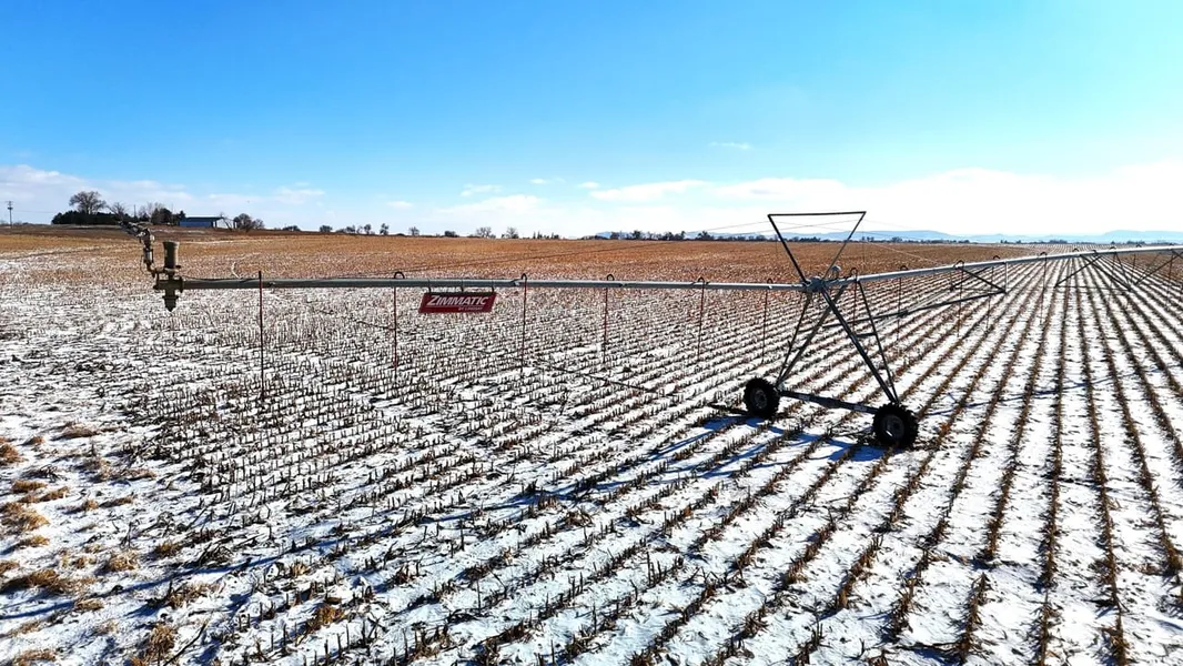
Offering #1 boosts of a newer Zimatic Pivot and highly productive soils. Currently in 2025 corn stubble the sale is subject to tenant rights. The irigation well permit number is G-039514 and is 170ft deep according to permit records. Irrigated farms in the area routinely produce 210+ bushel corn, 100+ bushel wheat, and 45+ bushel beans. This farm sits within the North Platte Irrigation District, which is head quartered out of Scottsbluff, NE. As an added bonus the farm offers some recreational opportunities with Spottedtail Creek & Tri State Canal near the western boundary of the property. Contact the listing Land Professional for more information or to schedule a showing. Showings by appointment only.
Property Details:
- Located North of Mitchell, NE
Pivot & Flood Irrigation
177.51+/- Irrigated Acres
Irrigation Well Permit # G-039514
Currently in 2025 Corn Stalks
Recreational Opportunities
Additional Acreage Available in the Area
***Acreage counts are believed to be accurate but have not been verified by a professional survey and were taken from the county assessor records. Crop yields can vary due to weather conditions and management practices. Potential buyers are advised to consult their experts to make their own analysis***
When purchasing a property listed by Great Plains Land Company, a Buyer's Broker, if applicable, must be identified on first contact and present at the initial showing of the property to participate in a real estate commission. If these conditions are not met, compensation if any will be at the sole discretion of Great Plains Land Company.
From elevation to risk assessment
Search for detailed parcel information including; Elevation & Vegetation Maps, Ownership Information, Detailed Parcel Information, Crop History Map, Soil Survey Productivity Data, and more.
Research Parcel InformationDirections
Environmental Factors
Resources
Land for Sale by Daniel Hunning
Scotts Bluff County Properties By Type
- Farms for Sale in Scotts Bluff County, Nebraska
- Ranches for Sale in Scotts Bluff County, Nebraska
- Hunting Land for Sale in Scotts Bluff County, Nebraska
- Riverfront Property for Sale in Scotts Bluff County, Nebraska
- Commercial Property for Sale in Scotts Bluff County, Nebraska
- Horse Property for Sale in Scotts Bluff County, Nebraska
- Residential Property for Sale in Scotts Bluff County, Nebraska
- Lakefront Property for Sale in Scotts Bluff County, Nebraska
- Undeveloped Land for Sale in Scotts Bluff County, Nebraska
- Recreational Property for Sale in Scotts Bluff County, Nebraska
- Timberland for Sale in Scotts Bluff County, Nebraska
- Beachfront Property for Sale in Scotts Bluff County, Nebraska
Properties for Sale Nearby Counties
Scotts Bluff County Properties By City
- Gering, Nebraska Land for Sale
- Lyman, Nebraska Land for Sale
- Mcgrew, Nebraska Land for Sale
- Melbeta, Nebraska Land for Sale
- Minatare, Nebraska Land for Sale
- Mitchell, Nebraska Land for Sale
- Morrill, Nebraska Land for Sale
- Scottsbluff, Nebraska Land for Sale
- Haig, Nebraska Land for Sale
- Henry, Nebraska Land for Sale
- Stegall, Nebraska Land for Sale
- Terrytown, Nebraska Land for Sale
- More
- Baxter, Nebraska Land for Sale
- Bradley, Nebraska Land for Sale
- Carlson, Nebraska Land for Sale
- Costin, Nebraska Land for Sale
- Covert, Nebraska Land for Sale
- Doyle, Nebraska Land for Sale
- Hartman, Nebraska Land for Sale
- Heldt, Nebraska Land for Sale
- Hillerage, Nebraska Land for Sale
- Hubbard Corner, Nebraska Land for Sale
- James, Nebraska Land for Sale
- Jane, Nebraska Land for Sale
- Janise, Nebraska Land for Sale
- Joyce, Nebraska Land for Sale
- Mintle, Nebraska Land for Sale
- Pelton, Nebraska Land for Sale
- Redus, Nebraska Land for Sale
- Sears, Nebraska Land for Sale
- South Mitchell, Nebraska Land for Sale
- South Morrill, Nebraska Land for Sale
- Tony, Nebraska Land for Sale
- Trout, Nebraska Land for Sale
