Bakersfield Forest
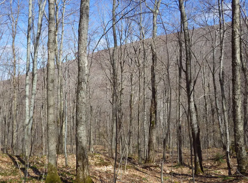
Bakersfield Forest is a conserved sugar maple and yellow birch forest offering an exceptional timber and/or sugarbush opportunity with over 60,000 potential taps with desirable downhill sap-flow. As a pure timber investment, the asking price is 96% of the $2,086,000 capital timber value. The property is set in the Cold Hollow Mountains in the towns of Bakersfield and Belvidere at the northern end of the Green Mountain Range in northwestern Vermont. Nearby state highways provide solid transportation to larger corridors and regional markets. Access to and within the property is well-established.
A northern aspect predominates on the property where terrain varies from steeply sloping within the southern half to more moderate and gentle slopes to the north. Forest management operability is quite good on the commercially operable terrain deemed and soil quality there is above average. The land includes the headwaters of Cold Hollow Brook, a scenic clear mountain stream which includes various cascades and a notable slab run where water flows along smooth bedrock for a considerable distance. The high elevation and wilderness setting of the propertys southern end provide scenic vistas and are a well-known area for producing large deer and bear.
The species composition is dominated by hardwoods, led by sugar maple (46%), followed by yellow birch (21%). The sawlog volume breakdown consists largely of species with historically strong demand, dominated by sugar maple and yellow birch. Forest stocking ranges from adequate in areas recently thinned to overstocked where thinning is scheduled. The property offers an outstanding potential sugarbush opportunity, given the high level of maple stocking, slope factor, access, and proximity to electric power. A recent analysis indicates a total maple potential tap count of 66,745 taps with roughly 93% of the taps from sugar maple with the balance from red maple. Electric power is roughly 1,100 from the propertys northwestern boundary along the town road, a point where nearly all of the sap will flow naturally downhill. The conservation easement permits forestry and sugarbush operations and associated infrastructure as well as an 800 sq ft camp.
From elevation to risk assessment
Search for detailed parcel information including; Elevation & Vegetation Maps, Ownership Information, Detailed Parcel Information, Crop History Map, Soil Survey Productivity Data, and more.
Research Parcel InformationResources
Land for Sale by Fountains Land
Franklin County Properties By Type
- Undeveloped Land for Sale in Franklin County, Vermont
- Lakefront Property for Sale in Franklin County, Vermont
- Commercial Property for Sale in Franklin County, Vermont
- Residential Property for Sale in Franklin County, Vermont
- Farms for Sale in Franklin County, Vermont
- Ranches for Sale in Franklin County, Vermont
- Recreational Property for Sale in Franklin County, Vermont
- Horse Property for Sale in Franklin County, Vermont
- Hunting Land for Sale in Franklin County, Vermont
- Timberland for Sale in Franklin County, Vermont
- Beachfront Property for Sale in Franklin County, Vermont
- Riverfront Property for Sale in Franklin County, Vermont
Properties for Sale Nearby Counties
Franklin County Properties By City
- Bakersfield, Vermont Land for Sale
- East Berkshire, Vermont Land for Sale
- East Fairfield, Vermont Land for Sale
- Enosburg Falls, Vermont Land for Sale
- Fairfax, Vermont Land for Sale
- Fairfield, Vermont Land for Sale
- Franklin, Vermont Land for Sale
- Highgate Center, Vermont Land for Sale
- Highgate Springs, Vermont Land for Sale
- Montgomery, Vermont Land for Sale
- Montgomery Center, Vermont Land for Sale
- Richford, Vermont Land for Sale
- More
- Saint Albans, Vermont Land for Sale
- Saint Albans Bay, Vermont Land for Sale
- Sheldon, Vermont Land for Sale
- Sheldon Springs, Vermont Land for Sale
- Swanton, Vermont Land for Sale
- Beaulieus Corner, Vermont Land for Sale
- Berkshire, Vermont Land for Sale
- Bordoville, Vermont Land for Sale
- East Enosburg, Vermont Land for Sale
- East Franklin, Vermont Land for Sale
- East Highgate, Vermont Land for Sale
- East Sheldon, Vermont Land for Sale
- Enosburg Center, Vermont Land for Sale
- Fletcher, Vermont Land for Sale
- Fonda, Vermont Land for Sale
- Hectorville, Vermont Land for Sale
- Highgate Falls, Vermont Land for Sale
- Hutchins, Vermont Land for Sale
- Maquam, Vermont Land for Sale
- Morses Line, Vermont Land for Sale
- Saint Rocks, Vermont Land for Sale
- Samsonville, Vermont Land for Sale
- Shawville, Vermont Land for Sale
- Sheldon Junction, Vermont Land for Sale
- West Berkshire, Vermont Land for Sale
- West Enosburg, Vermont Land for Sale
- West Swanton, Vermont Land for Sale
- Beattys Four Corners, Vermont Land for Sale
- Browns Corners, Vermont Land for Sale
- Camp Grounds, Vermont Land for Sale
- Camp Maquam, Vermont Land for Sale
- East Georgia, Vermont Land for Sale
- East Richford, Vermont Land for Sale
- Fairfax Falls, Vermont Land for Sale
- Georgia Center, Vermont Land for Sale
- Georgia Plains, Vermont Land for Sale
- Gilberts Tannery, Vermont Land for Sale
- Greens Corners, Vermont Land for Sale
- Hubbard Corner, Vermont Land for Sale
- Huntsville, Vermont Land for Sale
- Melville Landing, Vermont Land for Sale
- North Enosburg, Vermont Land for Sale
- North Fairfax, Vermont Land for Sale
- North Sheldon, Vermont Land for Sale
- Oakland, Vermont Land for Sale
- Sanderson Corner, Vermont Land for Sale
- Skeels Corner, Vermont Land for Sale
- South Franklin, Vermont Land for Sale
- South Richford, Vermont Land for Sale
- Stevens Mills, Vermont Land for Sale
- Swanton Junction, Vermont Land for Sale
- West Fletcher, Vermont Land for Sale
- West Georgia, Vermont Land for Sale
- West Hill, Vermont Land for Sale