226 acres in Clark County, Arkansas
Description
The Matthews Creek West tract (Listing #4260) will be offered by lump sum sealed bid on Friday, February 14, 2014, at 3:00 p.m.
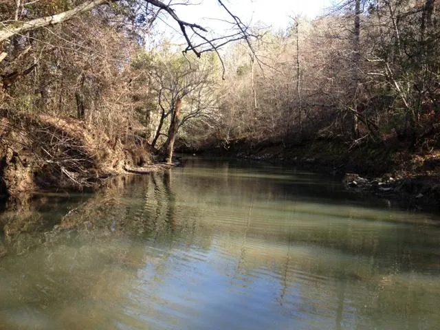
Tract Description: The tract is located approximately five (5) miles southeast of Amity and twenty-two (22) miles west of Arkadelphia. The tract offers beautiful vistas and public eoad frontage plus over 3/4 mile frontage on Matthews Creek, which makes up the north boundary of tract. Merchantable timbr includes 145 acres of merchantable pine plantations and 39 acres of native pine / hardwood. Premerchantable pine plantation acreage and year planted are as follows: 18 acres in 2003 and 19 acres in 2007. Terrain is gently rolling to steep. Loblolly pine site index averages 80 feet (base age 50) on fine sandy loam and silt loam soils. The property ofers excellent deer and turkey hunting, fishing, and recreation.
Merchantable Timber: Kingwood Forestry Services conducted a variable radius, 10 basal area factor prism inventory of merchantable timber (one point / 2 acres) with cruise lines running north and south (2 chains x 10 chains). Based on the inventory conducted by Kingwood Forestry in June, 2013 on 184 timbered ares, tree counts and volumes are estimated as follows:
Pine Sawtimber: 4,379 Trees; 213,700 BF; 2,829 Tons
White Oak Sawtimber: 100 Trees; 7,300 BF; 77 tons
Pine Pulpwood: 14,705 Trees; 946 Cords; 2,528 tons
Hardwood Pulpwood: 3,062 Trees; 210 Cords; 630 Tons
Due to variations in cruising methods, utilization standards and scaling practices, volume estimates cannot be guaranteed. Volume tables in tons are included in this notice; Board Feet tables are available upon request.
From elevation to risk assessment
Search for detailed parcel information including; Elevation & Vegetation Maps, Ownership Information, Detailed Parcel Information, Crop History Map, Soil Survey Productivity Data, and more.
Research Parcel InformationDirections
Driving Directions: From Alpine store on Highway 8, turn west on paved Center Ridge Road. Go 4.0 miles and turn left (south) on gravel Skipper Creek Road. Stay on Skipper Creek Road 1.0 miles to Matthews Creek slab, which is the north boundary of tract (see pink KFS flagging).
Environmental Factors
Clark County Properties By Type
- Undeveloped Land for Sale in Clark County, Arkansas
- Residential Property for Sale in Clark County, Arkansas
- Riverfront Property for Sale in Clark County, Arkansas
- Lakefront Property for Sale in Clark County, Arkansas
- Farms for Sale in Clark County, Arkansas
- Ranches for Sale in Clark County, Arkansas
- Recreational Property for Sale in Clark County, Arkansas
- Hunting Land for Sale in Clark County, Arkansas
- Timberland for Sale in Clark County, Arkansas
- Horse Property for Sale in Clark County, Arkansas
- Commercial Property for Sale in Clark County, Arkansas
- Beachfront Property for Sale in Clark County, Arkansas
Properties for Sale Nearby Counties
Clark County Properties By City
- Alpine, Arkansas Land for Sale
- Amity, Arkansas Land for Sale
- Arkadelphia, Arkansas Land for Sale
- Beirne, Arkansas Land for Sale
- Curtis, Arkansas Land for Sale
- Gurdon, Arkansas Land for Sale
- Okolona, Arkansas Land for Sale
- Whelen Springs, Arkansas Land for Sale
- Caddo Valley, Arkansas Land for Sale
- Dalark, Arkansas Land for Sale
- Fendley, Arkansas Land for Sale
- Griffithtown, Arkansas Land for Sale
- More
- Gum Springs, Arkansas Land for Sale
- Hollywood, Arkansas Land for Sale
- Joan, Arkansas Land for Sale
- Rosboro, Arkansas Land for Sale
- Barringer, Arkansas Land for Sale
- Burtsell, Arkansas Land for Sale
- Central, Arkansas Land for Sale
- Clear Spring, Arkansas Land for Sale
- Daleville, Arkansas Land for Sale
- De Gray, Arkansas Land for Sale
- Dobyville, Arkansas Land for Sale
- Gravel Junction, Arkansas Land for Sale
- Graysonia, Arkansas Land for Sale
- Halfway, Arkansas Land for Sale
- Haretown, Arkansas Land for Sale
- Kansas, Arkansas Land for Sale
- Lenox, Arkansas Land for Sale
- Love Creek, Arkansas Land for Sale
- Majors, Arkansas Land for Sale
- Meeks Settlement, Arkansas Land for Sale
- Pike Junction, Arkansas Land for Sale
- Red Springs, Arkansas Land for Sale
- Richwoods, Arkansas Land for Sale
- Shakertown, Arkansas Land for Sale
- Shawmut, Arkansas Land for Sale
- Smithton, Arkansas Land for Sale
- Sycamore, Arkansas Land for Sale
- Trace, Arkansas Land for Sale
- Vaden, Arkansas Land for Sale