Pinon Canyon Thatcher Ranch
Description
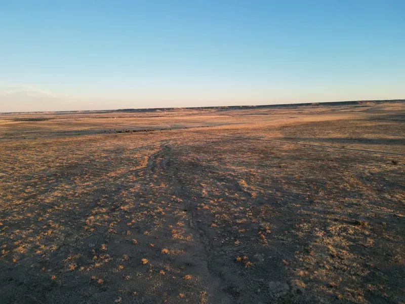
Expansive grassland consisting of 2,271 acres located north of Hwy 350 near Thatcher, CO. Located approximately 44 miles southwest of La Junta and 35 miles northeast of Trinidad, this property offers a variety of uses including grazing, hunting, recreation, and the option for a new home site. The majority of the property is flat grassland with drought tolerant grasses including Blue Grama and Buffalo Grass. On the elevated acreage there is Pinon and Juniper Tree coverage as well as a natural spring that carries water to the lower part of the property when ground water is high. There are ravines with sandy creek beds that carry seasonal water drainage, creating the perfect habitat for wildlife with protection from the pinons and the dirt and stone sidewalls of the ravines. The property is located in Game Management Unit 134, bringing a high value for hunters with the ability to apply for a land owner tag. Ten ponds are scattered throughout the ranch holding snow melt and rain. The two larger ponds at the center of the property hold water longer allowing cattle to drink year round. There are two wells on the property, the registered well is permitted for livestock & domestic use. There are multiple tanks on pipeline including one tank that is situated between 2 separate pastures. This allows water access from both sides of the tank in order to practice rotational grazing for grass management. There is 4 strand bared wire fencing along the perimeter of the ranch as well as cross fencing along the southern portion creating 3 separate pastures. An older homesite sits on the south east corner of the property and has a barn, corrals, two homes, multiple outbuildings, and a separate well. The improvements are easily accessible via County Road approximately 1.5 miles off of Highway 350. Incredible views of Fishers Peak and The Wet Mountains await.
A portion of the property has highway frontage and consists of approximately 116 acres. This is also being offered as a separate sale, if desired.
Well Information
Permit Number: 126603
620 feet deep
Permitted for dometsic & livestock use
Vegetation
Drought tolerant grasses including Blue Grama and Buffalo Grass
Pinon & Juniper Trees
Yucca & Cactus
Soil Types
Silt Loam
Silty Clay Loam
Additional Improvements
Homesite with 2 homes, barn, and pipe corrals
Secondary well
Wildlife
Mule Deer, Whitetail Deer, Antelope
Game Management Unit: 134
From elevation to risk assessment
Search for detailed parcel information including; Elevation & Vegetation Maps, Ownership Information, Detailed Parcel Information, Crop History Map, Soil Survey Productivity Data, and more.
Research Parcel InformationDirections
Environmental Factors
Resources
Las Animas County Properties By Type
- Ranches for Sale in Las Animas County, Colorado
- Undeveloped Land for Sale in Las Animas County, Colorado
- Hunting Land for Sale in Las Animas County, Colorado
- Farms for Sale in Las Animas County, Colorado
- Residential Property for Sale in Las Animas County, Colorado
- Timberland for Sale in Las Animas County, Colorado
- Recreational Property for Sale in Las Animas County, Colorado
- Riverfront Property for Sale in Las Animas County, Colorado
- Lakefront Property for Sale in Las Animas County, Colorado
- Horse Property for Sale in Las Animas County, Colorado
- Commercial Property for Sale in Las Animas County, Colorado
- Beachfront Property for Sale in Las Animas County, Colorado
Properties for Sale Nearby Counties
Las Animas County Properties By City
- Aguilar, Colorado Land for Sale
- Boncarbo, Colorado Land for Sale
- Branson, Colorado Land for Sale
- Hoehne, Colorado Land for Sale
- Kim, Colorado Land for Sale
- Model, Colorado Land for Sale
- Trinchera, Colorado Land for Sale
- Trinidad, Colorado Land for Sale
- Weston, Colorado Land for Sale
- Cokedale, Colorado Land for Sale
- Delhi, Colorado Land for Sale
- El Moro, Colorado Land for Sale
- More
- Jansen, Colorado Land for Sale
- Ludlow, Colorado Land for Sale
- Monument Park, Colorado Land for Sale
- San Miguel, Colorado Land for Sale
- Segundo, Colorado Land for Sale
- Starkville, Colorado Land for Sale
- Stonewall, Colorado Land for Sale
- Tercio, Colorado Land for Sale
- Tyrone, Colorado Land for Sale
- Vigil, Colorado Land for Sale
- Villegreen, Colorado Land for Sale
- Abeyta, Colorado Land for Sale
- Andrix, Colorado Land for Sale
- Barela, Colorado Land for Sale
- Beshoar, Colorado Land for Sale
- Cordova Plaza, Colorado Land for Sale
- Earl, Colorado Land for Sale
- Engleville, Colorado Land for Sale
- Gulnare, Colorado Land for Sale
- Houghton, Colorado Land for Sale
- Lynn, Colorado Land for Sale
- Medina Plaza, Colorado Land for Sale
- Parras Plaza, Colorado Land for Sale
- Patterson Crossing, Colorado Land for Sale
- Reilly Canyon, Colorado Land for Sale
- Rugby, Colorado Land for Sale
- Sarcillo, Colorado Land for Sale
- Sequndo, Colorado Land for Sale
- Simpson, Colorado Land for Sale
- Stonewall Gap, Colorado Land for Sale
- Tijeras, Colorado Land for Sale
- Tobe, Colorado Land for Sale
- Torres, Colorado Land for Sale
- Valdez, Colorado Land for Sale
- Vallorso, Colorado Land for Sale
- Velasquez Plaza, Colorado Land for Sale
- Walts Corner, Colorado Land for Sale
- Zamara, Colorado Land for Sale